We Serve 40+ Bay Area Communities in the Wildfire Zone
Most of these towns sit inside or right next to a CAL FIRE Very High Fire Hazard Severity Zone. That label changes everything - insurance, property values, and what you need to do to protect your home. We install sprinklers and hardening in all of them.
Loading satellite map…
Tap Your Location to See Local Wildfire Risk and Protection Options
Every community here has its own fire history, risk level, and terrain. Pick yours below to see what CAL FIRE says about your area - and what you can do about it.
Not sure about your property's risk level?
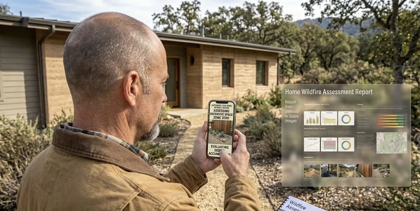
Get Your Free Wildfire ReportWant to know what wildfire risk models say about your property? Get your $149 report in minutes.
Get $149 Assessment Report →Book a free on-site evaluation. We will design and install the right sprinkler and hardening system for your home.
Book Free EvaluationGet the $149 assessment report. Find out what wildfire risk models flag on your property. Results in minutes.
Get $149 ReportWhat the WUI Means for Your Home
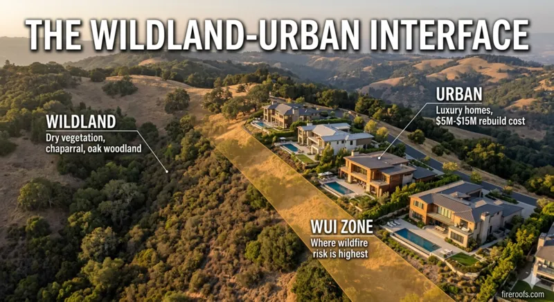
Living in the wildland-urban interface means living with a specific set of risks that most neighborhoods don't face. Embers travel miles ahead of a fire front. Dry vegetation on a hillside below your deck becomes fuel. A neighbor's wood fence becomes a lit fuse running straight to your wall.
CAL FIRE maintains Fire Hazard Severity Zone maps that classify every property in the state. The communities FireRoofs serves fall primarily into two categories: Very High Fire Hazard Severity Zone (VHFHSZ) and High Fire Hazard Severity Zone. That classification is what triggers insurance non-renewals, coverage restrictions, and the premium increases that have pushed more than 684,000 California homeowners onto the FAIR Plan.
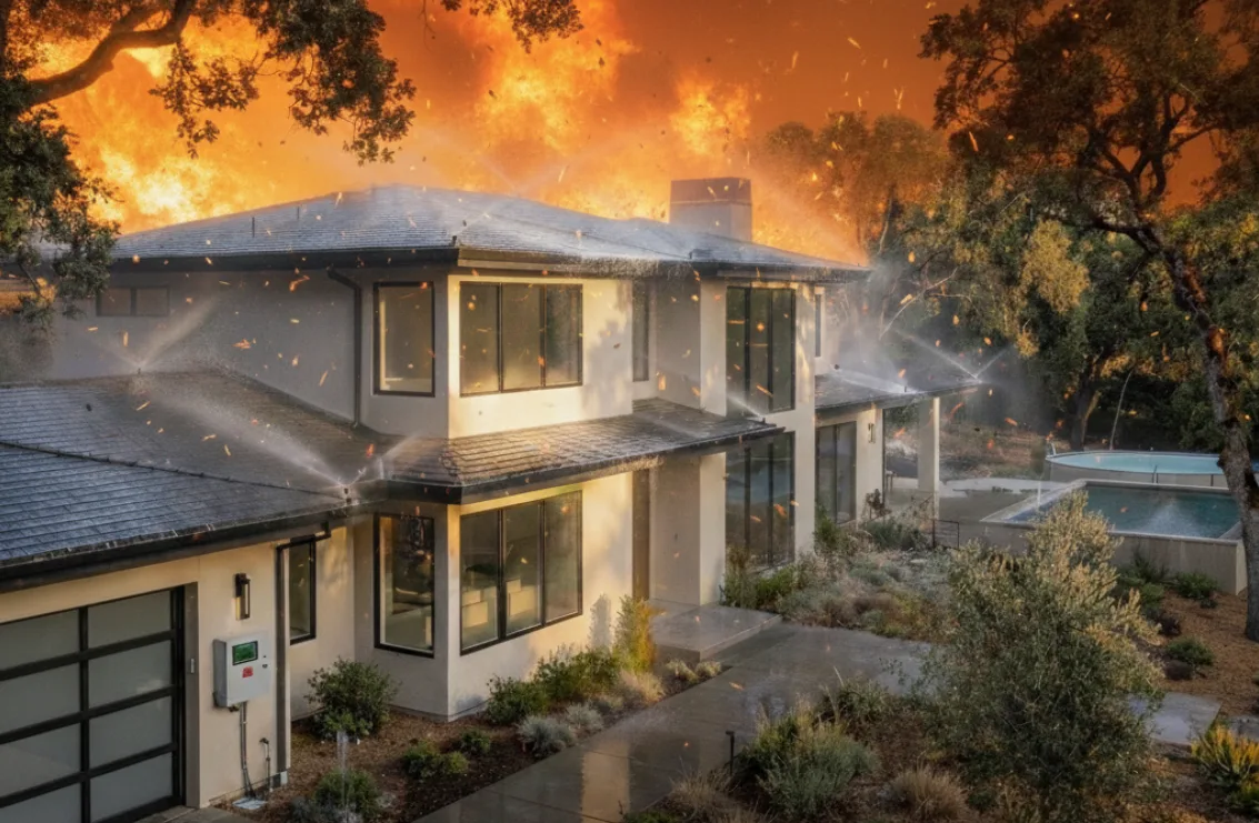
Defensible space and home hardening help. They are necessary. But for homes in the wildland-urban interface where rebuild costs run $5 million to $15 million, passive mitigation alone leaves a gap. That gap is what an automated exterior sprinkler system fills. Dual wildfire detection identifies threats. Automated sprinklers saturate your property. The system runs whether you are home or evacuated. That is the difference between passive risk reduction and active defense.
If you are not sure whether your property is in a WUI zone, check your city above or use our free wildfire risk tool.
Common Questions
How do I know if my home is in a wildland-urban interface zone?
CAL FIRE maintains official Fire Hazard Severity Zone maps for every California county. If your property borders open hillside, undeveloped wildland, or heavy vegetation, it likely falls within the WUI. You can check your designation using the CAL FIRE FHSZ Viewer or your county fire department records.
What is a Very High Fire Hazard Severity Zone?
A Very High Fire Hazard Severity Zone is CAL FIRE's most severe classification for wildfire risk. Properties in these zones face mandatory defensible space requirements, stricter building codes, and increasingly limited insurance options from private carriers.
Which Bay Area cities have the highest wildfire risk?
Saratoga, Los Gatos, Woodside, Portola Valley, Los Altos Hills, Scotts Valley, and Cupertino all contain Very High or High Fire Hazard Severity Zone designations from CAL FIRE. Monte Sereno, Emerald Hills, Stanford/Skyline, East Bay Hills, and Santa Cruz also carry Very High classifications, with an additional 11 communities rated High.
Where can I get instant answers about my city's wildfire risk?
HydroIQ is a free AI wildfire assistant that knows California wildfire law, insurance rules, local ordinances, and the science behind why homes burn. It covers communities across all nine Bay Area counties. No login, no cost. Visit fireroofs.com/hydroiq to ask a question.
Look Up Your Address and See What the Satellite Shows
You have seen the risk map. Now zoom in on your own property. Our satellite pre-assessment covers your roof, vegetation density, and fire zone classification. No email needed to get started.
- Satellite view focused on your specific property
- Fire zone and terrain risk for your address
- Full assessment with California code analysis available
Takes about a minute. No account needed.
Now that you know your risk level, here is what you can do to protect your home.
We install automated exterior sprinklers and full home hardening for Bay Area homes. Strong paperwork for your insurance broker.