Hayward Wildfire Defense
Hayward's wildfire exposure concentrates in the Hayward Hills and Fairview neighborhoods east of I-580, where suburban development climbs into the East Bay hills. The Hayward Fire Department has been one of the most proactive agencies in the Bay Area, running FEMA-funded defensible space demonstration projects and producing a community education video series. Despite these efforts, the combination of steep terrain, mature eucalyptus and Monterey pine, and older homes built before WUI codes creates ongoing risk. The 2022 vegetation fire near Garin Regional Park burned into the hillside above Five Canyons and required mutual aid from three neighboring agencies.
$149 Wildfire Report for Hayward Homeowners
See what California wildfire codes require for your Hayward property. Covers roof, vents, defensible space, and insurance paperwork. Get your report in minutes.
CAL FIRE Risk Designation
Alameda County
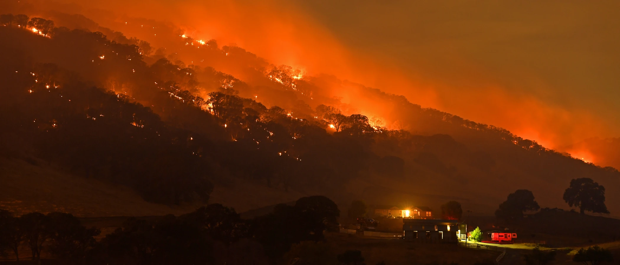
Hayward's hillside neighborhoods east of I-580 climb into the same East Bay hills that have produced major wildfires for over a century.
FireRoofs Premier Home Hardening & Active Defense
FireRoofs provides premier wildfire defense and home hardening for Hayward properties. We combine automated exterior wildfire sprinkler systems with structural hardening that addresses every ember entry point on the home. Learn more about wildfire roof sprinkler installation and how it works alongside defensible space in Hayward.
Automated Exterior Sprinklers
Dual-detection roof and perimeter sprinklers with satellite monitoring
Ember-Resistant Vents
Retrofit vents that seal the attic from ember intrusion
Noncombustible Fencing
Eliminate the fence-to-structure flame path
Zone Zero Hardening
Clear combustible material within 5 feet of the structure
Vegetation Fire Retardant
Applied to surrounding landscape for ember resistance
Insurance Evidence Packet
Mapped to California Regulation 2644.9 for carrier submission
Hayward stretches from the Bay flatlands to the East Bay Hills, with hillside neighborhoods directly exposed to wildfire from grassland and eucalyptus-covered slopes. The upper Hayward hills face some of the same fire behavior that devastated the Oakland-Berkeley Hills in 1991. FireRoofs provides targeted hardening for Hayward properties where residential construction meets wildland fuel loads.
Vulcan Vents Vent Retrofit for Hayward Hills Homes
Hayward hillside properties face wind-driven ember exposure from grassland and eucalyptus fires above. Legacy vents on older construction provide no meaningful ember protection. Vulcan Vents with ASTM E2886 certification and California State Fire Marshal listing replace outdated mesh with stainless steel ember screening and intumescent sealing, providing proven protection for Hayward's most fire-exposed homes.
Vulcan Vents - California ComplianceStainless Steel Gutter Guard Installation in Hayward
Hayward hills homes under eucalyptus and oak canopy accumulate bark strips and leaves in gutters that are among the most flammable debris types in the Bay Area. Our surgical-grade stainless steel micro mesh gutter guards eliminate this fuel buildup while resisting the corrosion that coastal moisture causes on lesser materials. For Hayward WUI properties, clean gutters significantly reduce the roof-edge ignition risk.
Fire Safe Marin - Gutter Hardening GuideLandscape-to-Structure Fuelbreak in Hayward
Hayward hillside properties often have eucalyptus mulch, ivy, and combustible ground cover extending to the foundation. Our noncombustible fuelbreak replaces these materials within the Zone 0 perimeter (0-5 feet) with gravel or hardscape, eliminating the fuel pathway between landscape and structure. For Hayward homes facing upslope fire behavior, this treatment is essential to preventing foundation-level ignition.
Board of Forestry - Zone 0 StandardsNon Combustible Gate and Fence for Hayward Homes
Wood fencing along Hayward hillside properties creates fire bridges from grassland to structures. Our noncombustible gate and fence installation replaces wood entry gates and perimeter fencing within 5 feet of the home with steel or aluminum materials meeting ASTM E136 standards. This Zone 0 compliance measure cuts the most direct fire transfer pathway on many Hayward WUI properties.
CA Dept of Insurance - Safer from WildfiresNon Combustible Deck Retrofit for Hayward Hills Properties
Hayward hillside homes with aging wood decks face dual exposure from ember landing on the deck surface and radiant heat from upslope fires. Our deck retrofit replaces combustible decking with materials certified under SFM Standard 12-7A-4, which tests resistance to both under-deck flame exposure and ember ignition. The result provides fire-rated deck surfaces designed for the East Bay Hills fire environment.
Fire Safe San Mateo - Deck HardeningWhy Home Hardening Matters in Hayward
The combination of VHFHSZ designation and Diablo wind exposure makes eastern Hayward a high-priority area for wildfire mitigation
FireRoofs provides the complete defense and hardening package for these hillside homes.

CAL FIRE Very High Fire Hazard Severity Zones (VHFHSZ) shown in red/orange
Source: CAL FIRE Fire Hazard Severity Zone data via Bay Area News Group
CAL FIRE High Fire Hazard Severity Zone
Very High and High FHSZ in Hayward Hills and Fairview areas. Valley floor and baylands are Moderate or not designated. Updated per 2025 CAL FIRE maps.
Hayward's Wildfire Record
Understanding past fires helps predict future risk. Here are the most significant fire events near Hayward.
The SCU Lightning Complex burned east of the region in the Diablo Range but did not enter Hayward directly. Smoke and air quality impacts affected the community during the fire event.
Multiple grass and brush fires have affected Hayward hills over the years. The city's eastern hillsides experience regular fire activity during dry season.
Local Risk Factors
Hayward Hills WUI
Hayward Hills and Fairview areas east of I-580/I-680 have substantial WUI exposure. Five Canyons and other hillside subdivisions have direct wildland adjacency.
Eucalyptus and Grassland Fuels
Significant eucalyptus groves on EBRPD lands create ember concerns. Oak woodland, annual grassland, and chaparral add to fuel loading on eastern hillsides.
East Bay Hills Canyon Effects
Diablo wind exposure combined with East Bay hills create canyon effects that accelerate fire spread. Red Flag Warnings are issued multiple times per year.
Limited Hillside Egress
Five Canyons, Fairview, and Hayward Hills neighborhoods have limited evacuation routes through canyon roads, creating potential bottlenecks during emergencies.
Book a free on-site evaluation. We will design and install the right sprinkler and hardening system for your home.
Book Free EvaluationAll work performed by licensed and insured contractors.
Get the $149 assessment report. Find out what wildfire risk models flag on your property. Results in minutes.
Get $149 ReportHayward Fire Environment
Vegetation Types
Wind Patterns
Diablo wind exposure; East Bay hills canyon wind effects; Red Flag Warnings multiple times per year
Topography
Western Hayward is flat and bayside. Eastern portions rise into Hayward Hills and Fairview areas with significant elevation changes. Five Canyons and hillside subdivisions have steep terrain with direct wildland adjacency.
Fire District
Hayward Fire Department
Insurance Impact
Hayward home values are moderate. Hillside neighborhoods in Hayward Hills and Fairview can exceed $1.5M-$3M. Some luxury hillside estates approach or exceed the $3M FAIR Plan cap. Valley floor homes are generally below cap.
Protecting Your Hayward Home & Family
Living in a fire-prone area means being proactive. Here are the steps every Hayward homeowner should take to protect their property and prepare for wildfire season.
Evacuation Planning
Primary routes include I-580, I-238, I-880, Foothill Boulevard, Mission Boulevard, and Grove Way. Hillside neighborhoods have limited egress through canyon roads. Register for AC Alert emergency notifications.
Defensible Space
Maintain 100 feet of defensible space with two zones (Zone 1 and Zone 2 per state law). The Hayward Fire Department completed a FEMA-funded Defensible Space Demonstration Project in the Hayward Hills and offers a three-part video series on defensible space best practices.


Your Local Fire Safe Council
Diablo Firesafe Council
The Diablo Firesafe Council offers free resources, community chipping programs, home assessments, and education to help Hayward residents reduce wildfire risk and prepare for fire season.
Visit Diablo Firesafe CouncilHayward Wildfire Preparedness Resources
Hayward Fire Preparedness
City of Hayward fire preparedness information, FHSZ maps, and community education resources.
City of HaywardHayward Defensible Space Projects
FEMA-funded Defensible Space Demonstration Project documentation and three-part video series.
Hayward FDCAL FIRE Defensible Space Guide
Official California guide to creating defensible space zones around your property.
CAL FIREProtect Your Hayward Home with FireRoofs
Defensible space and evacuation planning are essential, but they have limits. When embers are raining down and flames are approaching, your home needs both an automated active defense system and structural hardening that eliminates every ember entry point.
FireRoofs combines automated exterior sprinkler systems with structural home hardening for Hayward properties. Our Detect → Alert → Defend system uses intelligent wildfire detection cameras, satellite monitoring, and high-pressure water to saturate your property. Our hardening scope seals every vulnerability embers exploit.
- Automated exterior sprinklers: roof and perimeter coverage with dual detection
- Ember-resistant vent retrofits to seal the attic from intrusion
- Noncombustible fencing to eliminate the fence-to-structure flame path
- Zone Zero landscape hardening within 5 feet of the structure
- Vegetation fire retardant application for surrounding landscape
- Class A firefighting foam add-on: 100% biodegradable, non-toxic, rinses off through sprinklers
- Insurance evidence packet documenting all upgrades, mapped to California Regulation 2644.9


Local Wildfire Resources for Hayward Homeowners
Rules and requirements can change. Verify current requirements with your city or fire district before taking action.

Tree Removal and Defensible Space Rules
Hayward follows city code and Alameda County tree preservation standards. Fire hazard exemptions available. Hayward Fire Department enforces vegetation management in high hazard areas. Year-round compliance responsibility for defensible space.
Fire Hazard Severity Zone: Very High and High FHSZ in Hayward Hills and Fairview areas. Valley floor and baylands are Moderate or not designated. Updated per 2025 CAL FIRE maps.

Free Programs for Hayward Homeowners
- Hayward FD Defensible Space Demonstration Project (FEMA Hazard Mitigation Grant funded)
- Three-part video series on defensible space by Hayward FD
- Regional chipper programs
- Diablo Firesafe Council programs
Your Fire District
Hayward Fire Department (HFD) and Fairview Fire Protection District
Community Designations
- Firewise USA potential in hillside neighborhoods
- Part of Alameda County CWPP
Community designations like Firewise USA and Fire Risk Reduction Community may qualify homeowners for insurance benefits under California's Safer from Wildfires regulation.

Statewide Zone 0 Compliance Timeline
Board of Forestry rulemaking targeted for completion by December 31, 2025. New construction: compliance begins once rules are adopted (projected 2026). Existing structures: 3-year phase-in (compliance expected by approximately 2028-2029).
State Defensible Space (PRC 4291)
Zone 0: 0-5 feet, ember-resistant/noncombustible. Zone 1: 5-30 feet, lean, clean, and green. Zone 2: 30-100 feet, reduced fuel loading. Annual compliance inspections by local fire districts during fire season.
California Building Code
Effective 2026, California Wildland-Urban Interface Code (CWUIC) Part 7 replaces CBC Chapter 7A. Applies to new construction in designated fire hazard zones.
How FireRoofs Fits In
Understanding your local requirements is the first step. A FireRoofs automated defense system works alongside your defensible space, home hardening, and community efforts to give your home the strongest possible protection. During your free property evaluation, our team reviews your property in the context of Hayward's specific requirements and helps you understand how active defense fits into your overall wildfire strategy.
Nearby Communities We Serve
FireRoofs also installs wildfire defense systems in neighboring communities with similar WUI risk profiles.
2026 Insurance Alert for Hayward Homeowners
Homeowners in Hayward are facing surging FAIR Plan rates and non-renewals from private carriers. California's Safer from Wildfires framework now requires participating insurers to offer discounts for documented mitigation systems. FireRoofs provides the engineering documentation and evidence packet designed to help you qualify for the voluntary market.
California's SB 429 (effective January 1, 2026) establishes the nation's first public wildfire catastrophe model, giving homeowners new tools to understand insurance risk scores. Ask HydroIQ what this means for Hayward homeowners.
Request a Free Property EvaluationAsk HydroIQ About Hayward - Free AI Wildfire Assistant
Get instant answers about Hayward's wildfire risk level, defensible space requirements, fire history, FAIR Plan insurance options, and how exterior sprinkler systems can protect your home. HydroIQ covers communities across all nine Bay Area counties.
Protect Your Hayward Property Today
Every Hayward property is different. Get a free evaluation of your home's wildfire exposure and a custom defense plan.
Common Questions
What wildfire risk does Hayward face?
Hayward is designated a High fire risk zone by CAL FIRE. Alameda County fire maps confirm elevated exposure driven by oak woodland and eucalyptus groves fuel loads and dry-season wind patterns. Hayward Hills and Fairview areas east of I-580/I-680 have substantial WUI exposure. Five Canyons and other hillside subdivisions have direct wildland adjacency.
How does FireRoofs protect Hayward homes from wildfire?
FireRoofs provides both active defense and passive home hardening for Hayward properties. Active defense includes automated exterior sprinkler systems with dual detection, satellite monitoring, and intelligent fire detection cameras. Passive hardening covers ember-resistant vent retrofits, noncombustible fencing, Zone Zero landscape hardening, exterior cladding upgrades, and vegetation fire retardant. Every upgrade is documented in one evidence packet mapped to California Regulation 2644.9 for insurance recognition.
What does home hardening include for a Hayward property?
Home hardening for Hayward properties addresses every ember entry point on the structure. FireRoofs performs ember-resistant vent installation, noncombustible fencing replacement, eave and soffit sealing, Zone Zero landscape clearance within 5 feet of the structure, vegetation fire retardant application, and exterior cladding upgrades where needed. Scope is determined during a free property evaluation and accounts for local terrain and elevation changes. All work is documented for insurance submission.
Where can I get instant answers about Hayward's wildfire risk?
HydroIQ is FireRoofs' free wildfire assistant that provides instant, city-specific answers about Hayward's fire hazard zone classification, defensible space requirements, local fire history, FAIR Plan insurance options, and wildfire defense systems. No sign-up required. Visit fireroofs.com/hydroiq to learn more or ask a question directly.
What is California home hardening?
California home hardening is the process of retrofitting a structure to resist wildfire ember intrusion and radiant heat exposure. It includes replacing combustible building materials, sealing openings such as attic vents and eaves, installing noncombustible fencing, clearing the Zone Zero perimeter within 5 feet of the structure, and applying fire-resistant treatments. Home hardening is one of the 12 mitigation categories under California Regulation 2644.9 (Safer from Wildfires) that participating insurers must recognize when setting premiums.
How do I get off the California FAIR Plan?
To transition from the California FAIR Plan back to the voluntary insurance market, homeowners need to demonstrate documented wildfire risk reduction. This includes property-level mitigation such as home hardening, automated exterior sprinkler systems, and defensible space maintenance. Under California Regulation 2644.9, admitted insurers are required to offer premium discounts for documented mitigation across 12 categories. FireRoofs provides the upgrades and the evidence packet that documents each improvement for your insurer or broker.
What are the 12 Safer from Wildfires mitigation categories?
California Regulation 2644.9 defines 12 mitigation categories that insurers must recognize: (1) Class A fire-rated roof, (2) Enclosed eaves, (3) Ember-resistant vents, (4) Exterior wall cladding, (5) Dual-pane or tempered windows, (6) Noncombustible fencing within 5 feet, (7) Defensible space Zone 0-2 maintained, (8) Community-level mitigation (Fire Risk Reduction Community), (9) Active fire defense system such as exterior sprinklers, (10) Fire-resistant landscaping, (11) Access and water supply, (12) Structure-specific risk reduction. FireRoofs addresses categories 1 through 10 directly.
Do exterior roof sprinklers qualify for insurance discounts in California?
Yes. Automated exterior sprinkler systems are recognized under Category 9 (Active Fire Defense System) of California Regulation 2644.9. When documented in an evidence packet and submitted to your insurer, they count toward the mitigation credits that admitted carriers are required to apply. FireRoofs installs dual-detection exterior sprinkler systems and provides the documentation package for insurance recognition. SB 429 (effective January 1, 2026) further supports this by establishing a public wildfire catastrophe model that factors documented improvements into risk scoring.
What is Hayward's Defensible Space Demonstration Project?
Hayward Fire Department completed a FEMA-funded Defensible Space Demonstration Project in the Hayward Hills in Fall 2022 (grant awarded December 2020). The project included physical demonstrations and produced a three-part educational video series available on the Hayward FD website.
Which areas of Hayward face wildfire risk?
Hayward Hills and Fairview areas east of I-580/I-680 have the highest risk. Five Canyons and other hillside subdivisions have direct wildland adjacency. Western Hayward is flat and bayside with minimal wildfire exposure.
What fire departments serve Hayward?
Hayward Fire Department serves most of the city. Fairview areas are served by the Fairview Fire Protection District separately. Both work together in the hills. Contact [email protected] or (510) 583-4930 for fire safety information.