Palo Alto Wildfire Defense
Palo Alto's wildfire exposure is concentrated and well-documented. Approximately 130 homes in the Palo Alto Hills and Foothills Park area sit within designated fire hazard zones where the valley floor rises steeply into the Santa Cruz Mountains. These properties are accessed via Moody Road, Alexis Drive, and Page Mill Road, all narrow, winding routes through heavy tree canopy. In 2021, a vegetation fire along Arastradero Road required a multi-agency response and highlighted the access challenges that fire crews face in this terrain. The City of Palo Alto has invested in a fuel management program and an automated camera detection system for early fire spotting.
$149 Wildfire Report for Palo Alto Homeowners
See what California wildfire codes require for your Palo Alto property. Covers roof, vents, defensible space, and insurance paperwork. Get your report in minutes.
homes in the Very High Fire Hazard Severity Zone
Santa Clara County
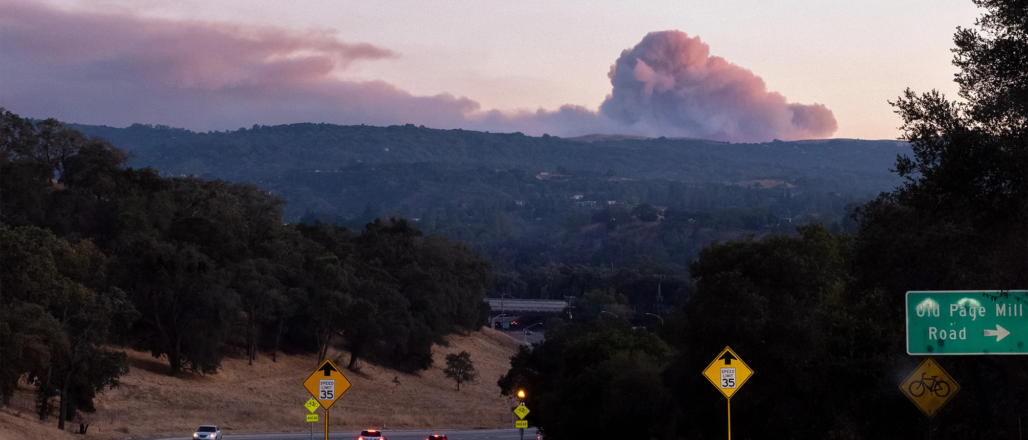
About 130 homes in the Palo Alto Hills and Foothills Park area sit within designated fire hazard zones accessed by narrow, winding roads.
FireRoofs Premier Home Hardening & Active Defense
FireRoofs provides premier wildfire defense and home hardening for Palo Alto properties. We combine automated exterior wildfire sprinkler systems with structural hardening that addresses every ember entry point on the home. Learn more about wildfire roof sprinkler installation and how it works alongside defensible space in Palo Alto.
Automated Exterior Sprinklers
Dual-detection roof and perimeter sprinklers with satellite monitoring
Ember-Resistant Vents
Retrofit vents that seal the attic from ember intrusion
Noncombustible Fencing
Eliminate the fence-to-structure flame path
Zone Zero Hardening
Clear combustible material within 5 feet of the structure
Vegetation Fire Retardant
Applied to surrounding landscape for ember resistance
Insurance Evidence Packet
Mapped to California Regulation 2644.9 for carrier submission
Palo Alto's foothills neighborhoods extend into the western hills along Page Mill Road, Arastradero Road, and the Stanford foothills, where residential areas border extensive open space preserves. These properties face wildfire exposure from grassland and oak woodland that dries rapidly during California's fire season. FireRoofs provides hardening retrofits designed for Palo Alto's unique combination of established architecture and wildland proximity.
Vulcan Vents Vent Retrofit for Palo Alto Foothills Homes
Palo Alto foothills properties face ember exposure from grassland and oak woodland fires in adjacent preserves. Many homes were built before WUI vent standards existed. Vulcan Vents with ASTM E2886 certification replace outdated mesh with dual-layer ember protection and intumescent sealing, meeting the Chapter 7A requirements that apply to Palo Alto's fire hazard zones.
Vulcan Vents - Codes & ComplianceMicro Mesh Gutter Guard Installation in Palo Alto
Palo Alto foothills homes under mature oak canopy collect heavy leaf litter in gutters throughout the year. During fire events, embers ignite this accumulated debris along the entire roof edge. Our noncombustible stainless steel micro mesh gutter guards prevent fuel buildup in gutters, maintaining the clean roof perimeter that home hardening programs recommend as a priority measure.
Santa Clara County FireSafe - Home HardeningOpen Eave Enclosure for Palo Alto Properties
Palo Alto's architectural heritage includes many homes with open eave construction that exposes rafter tails to ember intrusion. Our retrofit encloses open eaves with noncombustible soffit material and California State Fire Marshal-listed vents, bringing older foothills construction into alignment with current WUI building standards while preserving the architectural character of Palo Alto neighborhoods.
CALBO - Chapter 7A UpdatesUnder Deck Enclosure for Palo Alto Hillside Homes
Palo Alto foothills homes on sloped lots often have elevated decks with exposed undersides that collect windblown grass and leaves. Our noncombustible under deck enclosure seals this space with metal screening while maintaining ventilation, preventing ember-driven ignition of accumulated debris under the deck. This treatment follows the Safer from Wildfires framework guidelines for deck and under-deck protection.
CA Dept of Insurance - Safer from WildfiresLandscape Fuelbreak for Palo Alto Foothills Properties
Palo Alto foothills properties frequently have ornamental plantings and bark mulch extending to the foundation. During dry grass fire events, embers landing in this combustible material create immediate structural exposure. Our noncombustible fuelbreak replaces organic materials within the Zone 0 perimeter with gravel or hardscape, meeting AB 3074 requirements while preserving the foothills landscaping aesthetic.
Board of Forestry - Zone 0 RegulationsWhy Home Hardening Matters in Palo Alto
Palo Alto foothill homeowners face the same risk calculus as neighboring communities: valuable properties, limited evacuation options, and insurance carriers that are tightening underwriting standards year over year. FireRoofs addresses the foothill properties in Palo Alto with sprinkler systems designed for the terrain and home hardening that covers the full scope of mitigation categories
The evidence packet is your documentation for any insurance conversation.

CAL FIRE Very High Fire Hazard Severity Zones (VHFHSZ) shown in red/orange
Source: CAL FIRE Fire Hazard Severity Zone data via Bay Area News Group
CAL FIRE VHFHSZ Designation
Very High FHSZ is designated in the foothills area with approximately 130 homes in the hazard severity zone per the Palo Alto Fire Department. Local Responsibility Area. Updated per 2025 CAL FIRE maps.
Palo Alto's Wildfire Record
Understanding past fires helps predict future risk. Here are the most significant fire events near Palo Alto.
The SCU Lightning Complex burned in the Diablo Range to the east but did not enter Palo Alto. The city experienced smoke impacts during the fire event.
Park rangers from multiple jurisdictions conducted wildfire prevention training at Foothills Nature Preserve on October 8, 2025, reflecting the city's proactive approach to wildfire readiness.
Local Risk Factors
Steep Foothills Terrain
The Palo Alto Foothills area rises steeply from the valley floor into the Santa Cruz Mountains, creating challenging fire suppression conditions and limited evacuation routes.
Extensive Open Space
Foothills Nature Preserve (1,400+ acres), Pearson-Arastradero Preserve, and multiple MROSD preserves border residential areas with thousands of acres of wildland fuel.
Page Mill Road Wind Corridor
Diablo wind events from the northeast accelerate fires moving downslope. The Page Mill Road corridor experiences significant wind exposure during Red Flag conditions.
Limited Hillside Egress
Foothill neighborhoods have limited evacuation routes, primarily Page Mill Road, Alpine Road, and Arastradero Road, creating potential bottlenecks during emergencies.
Book a free on-site evaluation. We will design and install the right sprinkler and hardening system for your home.
Book Free EvaluationAll work performed by licensed and insured contractors.
Get the $149 assessment report. Find out what wildfire risk models flag on your property. Results in minutes.
Get $149 ReportPalo Alto Fire Environment
Vegetation Types
Wind Patterns
Diablo wind events from the northeast; Page Mill Road corridor wind exposure; Red Flag Warnings several times per fire season
Topography
Valley floor to steep foothills. Western edge rises into the Santa Cruz Mountains. Approximately 130 homes are situated in the steep foothill zone with significant elevation changes.
Fire District
Palo Alto Fire Department
Insurance Impact
Palo Alto foothill properties regularly exceed $5M, with many estates $10M+. All foothill properties exceed the $3M FAIR Plan dwelling coverage cap, creating significant underinsurance gaps for this luxury market.
Protecting Your Palo Alto Home & Family
Living in a fire-prone area means being proactive. Here are the steps every Palo Alto homeowner should take to protect their property and prepare for wildfire season.
Evacuation Planning
Know routes via Page Mill Road, Alpine Road, and Arastradero Road to I-280. Palo Alto updated its Emergency Operations Plan in 2025 with goals to contain fires to 10 acres or less while evacuating civilians. Register for AlertSCC notifications.
Defensible Space
Clear vegetation within 5 feet of structures annually as recommended by PAFD. Take advantage of free Home Ignition Zone assessments through the PAFD Ready, Set, Go! program. The city conducts routine fuel mitigation near roads and homes in the foothills year-round.


Your Local Fire Safe Council
Palo Alto Community Wildfire Protection Plan
The Palo Alto Community Wildfire Protection Plan offers free resources, community chipping programs, home assessments, and education to help Palo Alto residents reduce wildfire risk and prepare for fire season.
Visit Palo Alto Community Wildfire Protection PlanPalo Alto Wildfire Preparedness Resources
Palo Alto Fire Department
Free Home Ignition Zone assessments, Ready, Set, Go! program, and year-round vegetation mitigation in the foothills.
PAFDFoothills Nature Preserve
Information about wildfire management and prevention training in Palo Alto's adjacent open space.
City of Palo AltoCAL FIRE Defensible Space Guide
Official California guide to creating defensible space zones around your property.
CAL FIREProtect Your Palo Alto Home with FireRoofs
Defensible space and evacuation planning are essential, but they have limits. When embers are raining down and flames are approaching, your home needs both an automated active defense system and structural hardening that eliminates every ember entry point.
FireRoofs combines automated exterior sprinkler systems with structural home hardening for Palo Alto properties. Our Detect → Alert → Defend system uses intelligent wildfire detection cameras, satellite monitoring, and high-pressure water to saturate your property. Our hardening scope seals every vulnerability embers exploit.
- Automated exterior sprinklers: roof and perimeter coverage with dual detection
- Ember-resistant vent retrofits to seal the attic from intrusion
- Noncombustible fencing to eliminate the fence-to-structure flame path
- Zone Zero landscape hardening within 5 feet of the structure
- Vegetation fire retardant application for surrounding landscape
- Class A firefighting foam add-on: 100% biodegradable, non-toxic, rinses off through sprinklers
- Insurance evidence packet documenting all upgrades, mapped to California Regulation 2644.9


Local Wildfire Resources for Palo Alto Homeowners
Rules and requirements can change. Verify current requirements with your city or fire district before taking action.

Tree Removal and Defensible Space Rules
Palo Alto updated its Tree Protection Ordinance (PAMC Chapter 8.10) in June 2022. Protected trees include those 15 inches or greater in diameter (18 inches for redwoods). Invasive species and high water use trees are excluded from protection. Exceptions allow removal of trees deemed incompatible with environment or detrimental to adjacent protected trees.
Fire Hazard Severity Zone: Very High in foothills area. Approximately 130 homes within the hazard severity zone per PAFD. Local Responsibility Area.

Free Programs for Palo Alto Homeowners
- Free Home Ignition Zone (HIZ) assessments via PAFD Ready, Set, Go! program
- Routine city-led vegetation mitigation on Page Mill Road corridor
- Underground power line project in foothills (initiated 2025 by City of Palo Alto Utilities)
Your Fire District
Palo Alto Fire Department (PAFD, municipal)
Community Designations
- Active Ready, Set, Go! program participant
- Palo Alto Community Wildfire Protection Plan
Community designations like Firewise USA and Fire Risk Reduction Community may qualify homeowners for insurance benefits under California's Safer from Wildfires regulation.

Statewide Zone 0 Compliance Timeline
Board of Forestry rulemaking targeted for completion by December 31, 2025. New construction: compliance begins once rules are adopted (projected 2026). Existing structures: 3-year phase-in (compliance expected by approximately 2028-2029).
State Defensible Space (PRC 4291)
Zone 0: 0-5 feet, ember-resistant/noncombustible. Zone 1: 5-30 feet, lean, clean, and green. Zone 2: 30-100 feet, reduced fuel loading. Annual compliance inspections by local fire districts during fire season.
California Building Code
Effective 2026, California Wildland-Urban Interface Code (CWUIC) Part 7 replaces CBC Chapter 7A. Applies to new construction in designated fire hazard zones.
How FireRoofs Fits In
Understanding your local requirements is the first step. A FireRoofs automated defense system works alongside your defensible space, home hardening, and community efforts to give your home the strongest possible protection. During your free property evaluation, our team reviews your property in the context of Palo Alto's specific requirements and helps you understand how active defense fits into your overall wildfire strategy.
Nearby Communities We Serve
FireRoofs also installs wildfire defense systems in neighboring communities with similar WUI risk profiles.
2026 Insurance Alert for Palo Alto Homeowners
Homeowners in Palo Alto are facing surging FAIR Plan rates and non-renewals from private carriers. California's Safer from Wildfires framework now requires participating insurers to offer discounts for documented mitigation systems. FireRoofs provides the engineering documentation and evidence packet designed to help you qualify for the voluntary market.
California's SB 429 (effective January 1, 2026) establishes the nation's first public wildfire catastrophe model, giving homeowners new tools to understand insurance risk scores. Ask HydroIQ what this means for Palo Alto homeowners.
Request a Free Property EvaluationAsk HydroIQ About Palo Alto - Free AI Wildfire Assistant
Get instant answers about Palo Alto's wildfire risk level, defensible space requirements, fire history, FAIR Plan insurance options, and how exterior sprinkler systems can protect your home. HydroIQ covers communities across all nine Bay Area counties.
Protect Your Palo Alto Property Today
Every Palo Alto property is different. Get a free evaluation of your home's wildfire exposure and a custom defense plan.
Common Questions
What wildfire risk does Palo Alto face?
Palo Alto is designated a Very High Fire Hazard Severity Zone by CAL FIRE. Santa Clara County fire maps confirm extreme exposure driven by oak woodland and chaparral fuel loads and dry-season wind patterns. The Palo Alto Foothills area rises steeply from the valley floor into the Santa Cruz Mountains, creating challenging fire suppression conditions and limited evacuation routes.
How does FireRoofs protect Palo Alto homes from wildfire?
FireRoofs provides both active defense and passive home hardening for Palo Alto properties. Active defense includes automated exterior sprinkler systems with dual detection, satellite monitoring, and intelligent fire detection cameras. Passive hardening covers ember-resistant vent retrofits, noncombustible fencing, Zone Zero landscape hardening, exterior cladding upgrades, and vegetation fire retardant. Every upgrade is documented in one evidence packet mapped to California Regulation 2644.9 for insurance recognition.
What does home hardening include for a Palo Alto property?
Home hardening for Palo Alto properties addresses every ember entry point on the structure. FireRoofs performs ember-resistant vent installation, noncombustible fencing replacement, eave and soffit sealing, Zone Zero landscape clearance within 5 feet of the structure, vegetation fire retardant application, and exterior cladding upgrades where needed. Scope is determined during a free property evaluation and accounts for local terrain and elevation changes. All work is documented for insurance submission.
Where can I get instant answers about Palo Alto's wildfire risk?
HydroIQ is FireRoofs' free wildfire assistant that provides instant, city-specific answers about Palo Alto's fire hazard zone classification, defensible space requirements, local fire history, FAIR Plan insurance options, and wildfire defense systems. No sign-up required. Visit fireroofs.com/hydroiq to learn more or ask a question directly.
What is California home hardening?
California home hardening is the process of retrofitting a structure to resist wildfire ember intrusion and radiant heat exposure. It includes replacing combustible building materials, sealing openings such as attic vents and eaves, installing noncombustible fencing, clearing the Zone Zero perimeter within 5 feet of the structure, and applying fire-resistant treatments. Home hardening is one of the 12 mitigation categories under California Regulation 2644.9 (Safer from Wildfires) that participating insurers must recognize when setting premiums.
How do I get off the California FAIR Plan?
To transition from the California FAIR Plan back to the voluntary insurance market, homeowners need to demonstrate documented wildfire risk reduction. This includes property-level mitigation such as home hardening, automated exterior sprinkler systems, and defensible space maintenance. Under California Regulation 2644.9, admitted insurers are required to offer premium discounts for documented mitigation across 12 categories. FireRoofs provides the upgrades and the evidence packet that documents each improvement for your insurer or broker.
What are the 12 Safer from Wildfires mitigation categories?
California Regulation 2644.9 defines 12 mitigation categories that insurers must recognize: (1) Class A fire-rated roof, (2) Enclosed eaves, (3) Ember-resistant vents, (4) Exterior wall cladding, (5) Dual-pane or tempered windows, (6) Noncombustible fencing within 5 feet, (7) Defensible space Zone 0-2 maintained, (8) Community-level mitigation (Fire Risk Reduction Community), (9) Active fire defense system such as exterior sprinklers, (10) Fire-resistant landscaping, (11) Access and water supply, (12) Structure-specific risk reduction. FireRoofs addresses categories 1 through 10 directly.
Do exterior roof sprinklers qualify for insurance discounts in California?
Yes. Automated exterior sprinkler systems are recognized under Category 9 (Active Fire Defense System) of California Regulation 2644.9. When documented in an evidence packet and submitted to your insurer, they count toward the mitigation credits that admitted carriers are required to apply. FireRoofs installs dual-detection exterior sprinkler systems and provides the documentation package for insurance recognition. SB 429 (effective January 1, 2026) further supports this by establishing a public wildfire catastrophe model that factors documented improvements into risk scoring.
How many homes are in Palo Alto's fire hazard zone?
Approximately 130 homes are within the Very High Fire Hazard Severity Zone in the Palo Alto foothills per PAFD. These properties receive proactive inspection and vegetation management services.
Does Palo Alto have unique wildfire mitigation programs?
Yes. PAFD offers free Home Ignition Zone assessments through Ready, Set, Go! The city conducts year-round vegetation mitigation along Page Mill Road corridor and initiated a power line undergrounding project in the foothills in 2025.
Can I remove trees in Palo Alto for defensible space?
Tree removal requires a permit through Palo Alto Urban Forestry. Protected trees are 15 inches or greater in diameter. Exceptions exist for invasive species, high water use trees, and trees incompatible with the environment.