San Jose Wildfire Defense
San Jose is the largest city in the Bay Area, and most residents do not think of it as a wildfire city. But the eastern foothills along the Diablo Range tell a different story. Neighborhoods in Alum Rock, Evergreen, and Silver Creek back directly onto steep, grass-covered hillsides that ignite every summer. In 2021, a 4-alarm brush fire on Communications Hill forced evacuations of 100+ homes. In Alum Rock, grass fires regularly reach within 50 feet of back fences along Penitencia Creek Road. These are not rural properties. They are tract homes with wood fences, vinyl siding, and standard vents that were never built to resist ember exposure.
$149 Wildfire Report for San Jose Homeowners
See what California wildfire codes require for your San Jose property. Covers roof, vents, defensible space, and insurance paperwork. Get your report in minutes.
CAL FIRE Risk Designation
Santa Clara County
San Jose's eastern foothills place thousands of tract homes in the wildland-urban interface, with grass fires regularly reaching residential fences in Alum Rock and Evergreen.
FireRoofs Premier Home Hardening & Active Defense
FireRoofs provides premier wildfire defense and home hardening for San Jose properties. We combine automated exterior sprinkler systems with structural hardening that addresses every ember entry point on the home.
Automated Exterior Sprinklers
Dual-detection roof and perimeter sprinklers with satellite monitoring
Ember-Resistant Vents
Retrofit vents that seal the attic from ember intrusion
Noncombustible Fencing
Eliminate the fence-to-structure flame path
Zone Zero Hardening
Clear combustible material within 5 feet of the structure
Vegetation Fire Retardant
Applied to surrounding landscape for ember resistance
Insurance Evidence Packet
Mapped to California Regulation 2644.9 for carrier submission
San Jose is the largest city in the Bay Area, with eastern and southern neighborhoods extending into the Diablo Range and Santa Cruz Mountain foothills. Properties in the Almaden Valley, Alum Rock, and communications hill areas face wildfire exposure from grassland and chaparral. FireRoofs provides home hardening for San Jose WUI properties where suburban development meets wildland terrain.
EmberSafe Gutter Guard Installation in San Jose
San Jose hillside and foothill homes collect grass seed, oak leaf, and chaparral debris in gutters during the extended dry season. The hot San Jose climate desiccates gutter contents to flashpoint. Our stainless steel micro mesh gutter guards maintain noncombustible gutters year-round, protecting the roof edge from ember ignition on San Jose WUI properties.
Santa Clara County FireSafe - Home HardeningVulcan Vents Vent Retrofit for San Jose WUI Homes
San Jose homes in the foothills and Almaden area face ember showers from fast-moving grassland fires. Standard mesh vents on older construction allow these embers direct access to the attic. Vulcan Vents with ASTM E2886 certification provide stainless steel ember screening and intumescent sealing that blocks both wind-driven embers and flame, meeting Chapter 7A standards for San Jose fire hazard zones.
Vulcan Vents - California WUI ComplianceLandscape-to-Structure Fuelbreak for San Jose Properties
San Jose foothill properties often have bark mulch and combustible plantings at the foundation line where residential lots meet wildland. Our noncombustible fuelbreak replaces these materials within the Zone 0 perimeter with gravel or hardscape, denying embers the foundation-level fuel that leads to wall ignition during grassland fire events. This meets AB 3074 ember-resistant zone requirements.
Board of Forestry - Zone 0 StandardsNon Combustible Fencing for San Jose Foothill Homes
Wood fencing along San Jose foothill property lines creates direct fire pathways from grassland to homes. Our noncombustible fencing installation replaces wood sections within 5 feet of the structure with steel or aluminum panels meeting ASTM E136 standards. This Zone 0 compliance measure is essential for San Jose WUI properties where grass fires can reach residential areas quickly.
Ready for Wildfire - Defensible SpaceOpen Eave Enclosure for San Jose Homes
Many San Jose homes in older hillside neighborhoods have open eave construction that provides ember entry into the attic. Our retrofit encloses eaves with noncombustible soffit material and WUI-rated vents meeting ASTM E2886 standards, sealing the most common structural ignition pathway while maintaining proper attic ventilation per California building requirements.
CALBO - WUI Building CodesWhy Home Hardening Matters in San Jose
San Jose’s fire-zone neighborhoods are often treated as an afterthought in a city focused on the valley floor. But the homes in Almaden and Alum Rock hillsides face the same fire physics as any VHFHSZ community
FireRoofs brings the same premier defense and hardening service to San Jose’s WUI neighborhoods that we provide in Saratoga and Los Gatos.

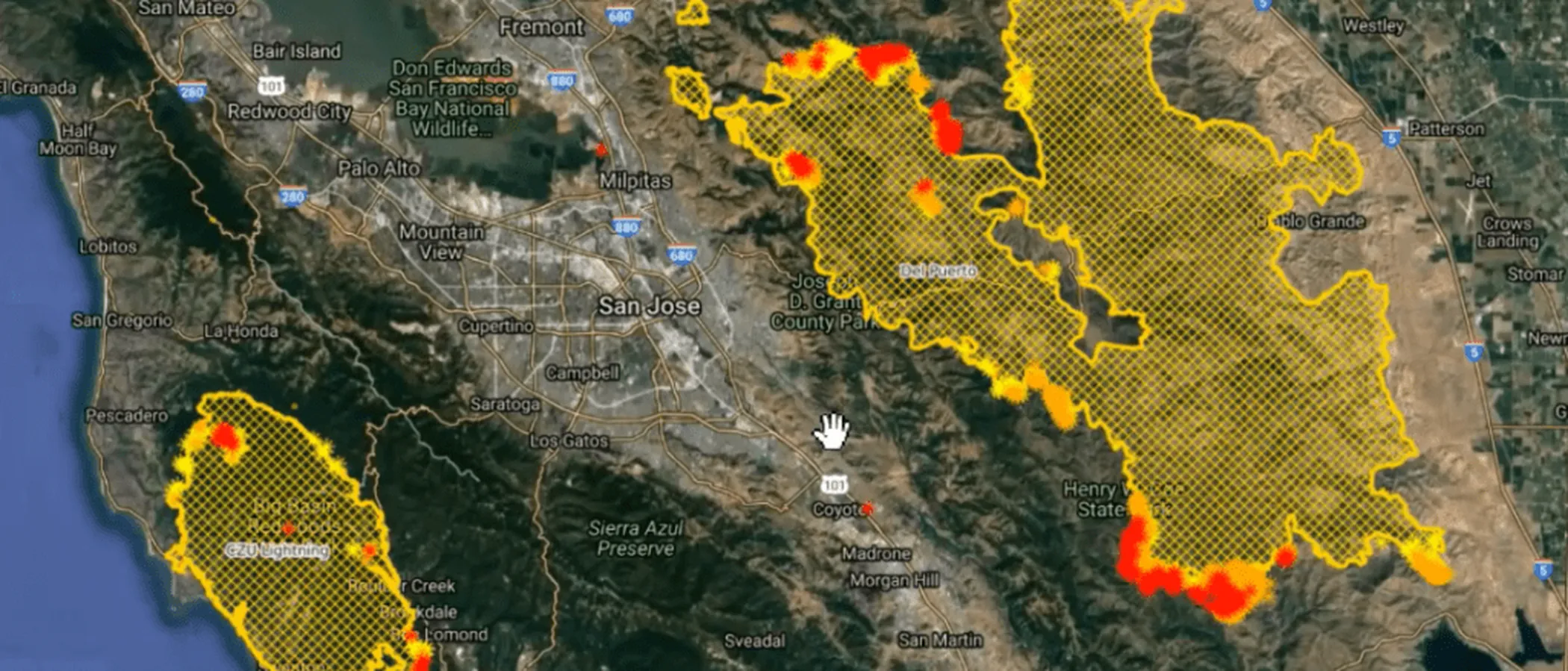
CAL FIRE Very High Fire Hazard Severity Zones (VHFHSZ) shown in red/orange
Source: CAL FIRE Fire Hazard Severity Zone data via Bay Area News Group
CAL FIRE High Fire Hazard Severity Zone
Portions of San Jose fall within CAL FIRE's Fire Hazard Severity Zone designations, concentrated along the eastern foothills from Alum Rock through Evergreen to the Coyote Valley.
San Jose's Wildfire Record
Understanding past fires helps predict future risk. Here are the most significant fire events near San Jose.
Burned 396,625 acres across Santa Clara, Alameda, and Stanislaus Counties. Evacuation orders were issued for areas east of San Jose city limits, south of Mt. Hamilton Road.
Burned 47,760 acres on the eastern slopes of Mt. Hamilton, threatening San Jose's eastern neighborhoods and watersheds.
Burned 1,521 acres in the hills south of San Jose near Uvas Canyon, destroying multiple structures in the rural-urban interface.
Local Risk Factors
Eastern Foothill WUI
Thousands of homes are built into the Diablo Range foothills, directly abutting dry grassland and chaparral that burns rapidly in wind-driven fires.
Northeast Wind Corridor
Hot, dry northeast winds funnel through Calaveras and Alum Rock corridors, rapidly pushing fires from wildlands into residential neighborhoods.
Water Infrastructure Challenges
Hillside water systems in east San Jose operate at lower pressure. During large fires, simultaneous demand can overwhelm hydrant supply.
Urban-Wildland Density
San Jose's eastern edge has some of the densest WUI development in California, with subdivisions extending deep into fire-prone terrain.
Book a free on-site evaluation. We will design and install the right sprinkler and hardening system for your home.
Book Free EvaluationGet the $149 assessment report. Find out what wildfire risk models flag on your property. Results in minutes.
Get $149 ReportSan Jose Fire Environment
Vegetation Types
Wind Patterns
Hot, dry northeast winds in fall; sea breeze (NW) in summer; funneling through Calaveras corridor
Topography
Elevation ranges from 80 ft at valley floor to 4,200 ft at Mt. Hamilton. Steep east-facing slopes create fire chimneys.
Fire District
San Jose Fire Department, multiple stations in eastern foothills
Insurance Impact
Eastern foothill properties in San Jose are increasingly seeing non-renewals from private insurers. FAIR Plan enrollments in Santa Clara County's WUI zones have increased significantly.
Protecting Your San Jose Home & Family
Living in a fire-prone area means being proactive. Here are the steps every San Jose homeowner should take to protect their property and prepare for wildfire season.
Evacuation Planning
San Jose's eastern foothills have multiple evacuation routes but they funnel onto a few major arteries (Alum Rock Ave, Story Rd, Capitol Expressway). Register for AlertSCC and know your Zonehaven zone. During hot, dry wind events, leave early. hillside traffic will gridlock fast.
Defensible Space
San Jose requires 100 feet of defensible space for hillside properties. The Santa Clara County FireSafe Council offers free HIZ inspections and up to $10,000 in structure hardening rebates. Clear dry grass within 30 feet of structures and remove overhanging branches.


Your Local Fire Safe Council
Santa Clara County FireSafe Council
The Santa Clara County FireSafe Council offers free resources, community chipping programs, home assessments, and education to help San Jose residents reduce wildfire risk and prepare for fire season.
Visit Santa Clara County FireSafe CouncilSan Jose Wildfire Preparedness Resources
Santa Clara County FireSafe Council
Free chipping, HIZ inspections, defensible space assistance, and structure hardening rebates for WUI residents.
SCC FireSafe CouncilSan Jose Fire Department Wildfire Preparedness
City of San Jose wildfire preparedness information, FHSZ maps, and defensible space requirements.
City of San JoseCAL FIRE Defensible Space Guide
Official California guide to creating defensible space zones around your property.
CAL FIREProtect Your San Jose Home with FireRoofs
Defensible space and evacuation planning are essential, but they have limits. When embers are raining down and flames are approaching, your home needs both an automated active defense system and structural hardening that eliminates every ember entry point.
FireRoofs combines automated exterior sprinkler systems with structural home hardening for San Jose properties. Our Detect → Alert → Defend system uses intelligent wildfire detection cameras, satellite monitoring, and high-pressure water to saturate your property. Our hardening scope seals every vulnerability embers exploit.
- Automated exterior sprinklers: roof and perimeter coverage with dual detection
- Ember-resistant vent retrofits to seal the attic from intrusion
- Noncombustible fencing to eliminate the fence-to-structure flame path
- Zone Zero landscape hardening within 5 feet of the structure
- Vegetation fire retardant application for surrounding landscape
- Class A firefighting foam add-on: 100% biodegradable, non-toxic, rinses off through sprinklers
- Insurance evidence packet documenting all upgrades, mapped to California Regulation 2644.9


Local Wildfire Resources for San Jose Homeowners
Rules and requirements can change. Verify current requirements with your city or fire district before taking action.

Tree Removal and Defensible Space Rules
Follows county rules with fire hazard exceptions for ladder fuels and high-risk species. Heritage tree ordinance allows VHFHSZ removals.
Fire Hazard Severity Zone: Very High in Almaden Valley and Silver Creek hills (50-70% of WUI areas per 2025 maps). Local Responsibility Area.

Free Programs for San Jose Homeowners
- San Jose FD offers free wildfire safety visits in WUI neighborhoods including Suncrest
- SCCFD chipper days for VHFHSZ residents
Community Designations
- Firewise USA in Almaden neighborhoods
Community designations like Firewise USA and Fire Risk Reduction Community may qualify homeowners for insurance benefits under California's Safer from Wildfires regulation.

Statewide Zone 0 Compliance Timeline
Board of Forestry rulemaking targeted for completion by December 31, 2025. New construction: compliance begins once rules are adopted (projected 2026). Existing structures: 3-year phase-in (compliance expected by approximately 2028-2029).
State Defensible Space (PRC 4291)
Zone 0: 0-5 feet, ember-resistant/noncombustible. Zone 1: 5-30 feet, lean, clean, and green. Zone 2: 30-100 feet, reduced fuel loading. Annual compliance inspections by local fire districts during fire season.
California Building Code
Effective 2026, California Wildland-Urban Interface Code (CWUIC) Part 7 replaces CBC Chapter 7A. Applies to new construction in designated fire hazard zones.
How FireRoofs Fits In
Understanding your local requirements is the first step. A FireRoofs automated defense system works alongside your defensible space, home hardening, and community efforts to give your home the strongest possible protection. During your free property evaluation, our team reviews your property in the context of San Jose's specific requirements and helps you understand how active defense fits into your overall wildfire strategy.
Nearby Communities We Serve
FireRoofs also installs wildfire defense systems in neighboring communities with similar WUI risk profiles.
2026 Insurance Alert for San Jose Homeowners
Homeowners in San Jose are facing surging FAIR Plan rates and non-renewals from private carriers. California's Safer from Wildfires framework now requires participating insurers to offer discounts for documented mitigation systems. FireRoofs provides the engineering documentation and evidence packet designed to help you qualify for the voluntary market.
California's SB 429 (effective January 1, 2026) establishes the nation's first public wildfire catastrophe model, giving homeowners new tools to understand insurance risk scores. Ask HydroIQ what this means for San Jose homeowners.
Request a Free Property EvaluationAsk HydroIQ About San Jose - Free AI Wildfire Assistant
Get instant answers about San Jose's wildfire risk level, defensible space requirements, fire history, FAIR Plan insurance options, and how exterior sprinkler systems can protect your home. HydroIQ covers communities across all nine Bay Area counties.
Protect Your San Jose Property Today
Every San Jose property is different. Get a free evaluation of your home's wildfire exposure and a custom defense plan.
Common Questions
What wildfire risk does San Jose face?
San Jose is designated a High fire risk zone by CAL FIRE. Santa Clara County fire maps confirm elevated exposure driven by annual grassland and chaparral fuel loads and dry-season wind patterns. Thousands of homes are built into the Diablo Range foothills, directly abutting dry grassland and chaparral that burns rapidly in wind-driven fires.
How does FireRoofs protect San Jose homes from wildfire?
FireRoofs provides both active defense and passive home hardening for San Jose properties. Active defense includes automated exterior sprinkler systems with dual detection, satellite monitoring, and intelligent fire detection cameras. Passive hardening covers ember-resistant vent retrofits, noncombustible fencing, Zone Zero landscape hardening, exterior cladding upgrades, and vegetation fire retardant. Every upgrade is documented in one evidence packet mapped to California Regulation 2644.9 for insurance recognition.
What does home hardening include for a San Jose property?
Home hardening for San Jose properties addresses every ember entry point on the structure. FireRoofs performs ember-resistant vent installation, noncombustible fencing replacement, eave and soffit sealing, Zone Zero landscape clearance within 5 feet of the structure, vegetation fire retardant application, and exterior cladding upgrades where needed. Scope is determined during a free property evaluation and accounts for local terrain and elevation changes. All work is documented for insurance submission.
Where can I get instant answers about San Jose's wildfire risk?
HydroIQ is FireRoofs' free wildfire assistant that provides instant, city-specific answers about San Jose's fire hazard zone classification, defensible space requirements, local fire history, FAIR Plan insurance options, and wildfire defense systems. No sign-up required. Visit fireroofs.com/hydroiq to learn more or ask a question directly.
What is California home hardening?
California home hardening is the process of retrofitting a structure to resist wildfire ember intrusion and radiant heat exposure. It includes replacing combustible building materials, sealing openings such as attic vents and eaves, installing noncombustible fencing, clearing the Zone Zero perimeter within 5 feet of the structure, and applying fire-resistant treatments. Home hardening is one of the 12 mitigation categories under California Regulation 2644.9 (Safer from Wildfires) that participating insurers must recognize when setting premiums.
How do I get off the California FAIR Plan?
To transition from the California FAIR Plan back to the voluntary insurance market, homeowners need to demonstrate documented wildfire risk reduction. This includes property-level mitigation such as home hardening, automated exterior sprinkler systems, and defensible space maintenance. Under California Regulation 2644.9, admitted insurers are required to offer premium discounts for documented mitigation across 12 categories. FireRoofs provides the upgrades and the evidence packet that documents each improvement for your insurer or broker.
What are the 12 Safer from Wildfires mitigation categories?
California Regulation 2644.9 defines 12 mitigation categories that insurers must recognize: (1) Class A fire-rated roof, (2) Enclosed eaves, (3) Ember-resistant vents, (4) Exterior wall cladding, (5) Dual-pane or tempered windows, (6) Noncombustible fencing within 5 feet, (7) Defensible space Zone 0-2 maintained, (8) Community-level mitigation (Fire Risk Reduction Community), (9) Active fire defense system such as exterior sprinklers, (10) Fire-resistant landscaping, (11) Access and water supply, (12) Structure-specific risk reduction. FireRoofs addresses categories 1 through 10 directly.
Do exterior roof sprinklers qualify for insurance discounts in California?
Yes. Automated exterior sprinkler systems are recognized under Category 9 (Active Fire Defense System) of California Regulation 2644.9. When documented in an evidence packet and submitted to your insurer, they count toward the mitigation credits that admitted carriers are required to apply. FireRoofs installs dual-detection exterior sprinkler systems and provides the documentation package for insurance recognition. SB 429 (effective January 1, 2026) further supports this by establishing a public wildfire catastrophe model that factors documented improvements into risk scoring.
Are San Jose WUI homeowners eligible for free wildfire programs?
Yes. The San Jose Fire Department offers free wildfire safety visits in WUI neighborhoods including Suncrest. SCCFD provides chipper days for VHFHSZ residents. Visit sccfd.org for scheduling.
Is the Almaden Valley area a Firewise community?
Yes. Almaden Valley neighborhoods hold Firewise USA recognition, which may qualify homeowners for insurance benefits under California's Safer from Wildfires regulation.