Milpitas Wildfire Defense
Milpitas may be known for its tech corridor and the Great Mall, but its eastern edge rises into the Diablo Range where wildfire risk is very real. Neighborhoods along Calaveras Road, Hillview Drive, and the eastern slope of Ed Levin County Park back directly onto steep grassland that dries to flash fuel every summer. In 2020, a 4-alarm grass fire on the hillside above Calaveras Boulevard forced evacuations of homes along the ridgeline. The city's eastern WUI boundary has been expanded in the 2025 FHSZ reclassification, and several hundred homes now carry fire hazard designations that trigger new insurance and disclosure requirements.
$149 Wildfire Report for Milpitas Homeowners
See what California wildfire codes require for your Milpitas property. Covers roof, vents, defensible space, and insurance paperwork. Get your report in minutes.
CAL FIRE Risk Designation
Santa Clara County
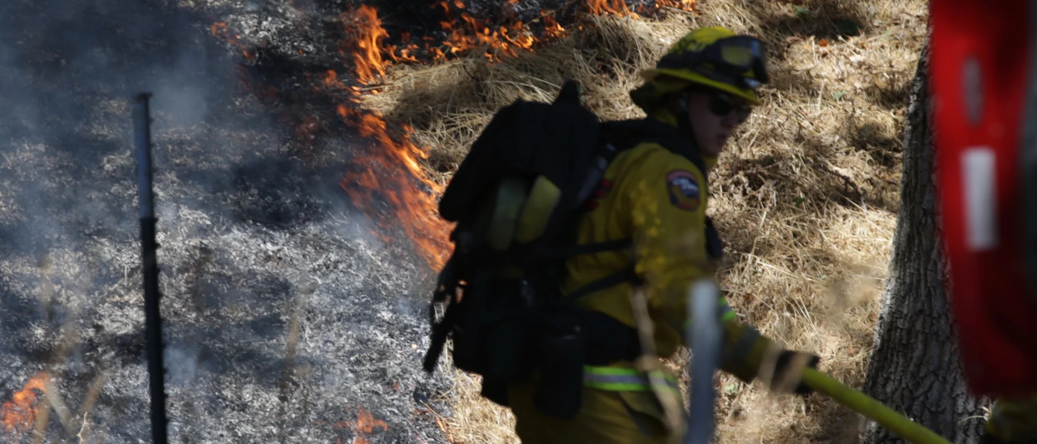
Milpitas' eastern hillsides along Calaveras Road and Ed Levin Park transition sharply from suburban development to fire-prone grassland.
FireRoofs Premier Home Hardening & Active Defense
FireRoofs provides premier wildfire defense and home hardening for Milpitas properties. We combine automated exterior wildfire sprinkler systems with structural hardening that addresses every ember entry point on the home. Learn more about wildfire roof sprinkler installation and how it works alongside defensible space in Milpitas.
Automated Exterior Sprinklers
Dual-detection roof and perimeter sprinklers with satellite monitoring
Ember-Resistant Vents
Retrofit vents that seal the attic from ember intrusion
Noncombustible Fencing
Eliminate the fence-to-structure flame path
Zone Zero Hardening
Clear combustible material within 5 feet of the structure
Vegetation Fire Retardant
Applied to surrounding landscape for ember resistance
Insurance Evidence Packet
Mapped to California Regulation 2644.9 for carrier submission
Milpitas extends from the Bay shore to the Diablo Range foothills, with neighborhoods along the eastern hills facing wildfire exposure from grassland and chaparral. The Ed Levin County Park area and Calaveras Hills create a direct wildland-urban interface. FireRoofs provides home hardening for Milpitas properties where foothill development meets seasonal fire risk.
Vulcan Vents Vent Retrofit for Milpitas Foothill Homes
Milpitas foothill homes face ember exposure from grassland fires in the adjacent Diablo Range. Vents on older construction allow embers to enter attic spaces. Vulcan Vents with ASTM E2886 certification and California State Fire Marshal listing provide stainless steel ember screening and intumescent sealing that blocks embers and flame, meeting the WUI vent standards for Milpitas fire hazard zones.
Vulcan Vents - California ComplianceMicro Mesh Gutter Guard Installation in Milpitas
Milpitas hillside homes collect dry grass and oak leaf debris in gutters during the fire season. Our stainless steel micro mesh gutter guards prevent combustible fuel buildup in gutters, maintaining a noncombustible roof perimeter. This is a priority hardening measure for Milpitas homes near the Calaveras Hills and Ed Levin Park wildland areas.
Santa Clara County FireSafe - Home HardeningNon Combustible Gate and Fence for Milpitas WUI Properties
Milpitas properties near the hillside interface often have wood fencing and gates that create direct fire pathways from grassland to structures. Our noncombustible gate and fence installation replaces combustible wood with aluminum or steel materials meeting ASTM E136 standards. This Zone 0 treatment eliminates the fence-to-structure fire transfer that is a primary cause of home ignition during grassland fires.
CA Dept of Insurance - Safer from WildfiresOpen Eave Enclosure for Milpitas Hillside Homes
Older Milpitas homes in the foothill areas often have open eave construction that exposes rafter tails and creates ember entry points. Our eave enclosure retrofit installs noncombustible soffit material with WUI-compliant vents meeting ASTM E2886 standards, converting open eaves to the enclosed configuration Chapter 7A requires for wildfire-exposed construction.
CALBO - Chapter 7A WUI StandardsLandscape Fuelbreak for Milpitas Foothill Properties
Milpitas foothill properties often have combustible mulch and plantings at the foundation where residential lots meet wildland. Our fuelbreak replaces organic materials within the 0-5 foot Zone 0 perimeter with gravel or decomposed granite, creating the noncombustible buffer AB 3074 requires between landscape and structure. This treatment is critical for Milpitas homes exposed to grassland fire embers.
Board of Forestry - Zone 0 RequirementsWhy Home Hardening Matters in Milpitas
Eastern Milpitas homeowners face rising insurance costs and non-renewal risk as carriers tighten WUI zone underwriting
FireRoofs provides sprinkler systems and home hardening for these hillside properties, documented in an evidence packet that gives carriers a reason to offer coverage.

CAL FIRE Very High Fire Hazard Severity Zones (VHFHSZ) shown in red/orange
Source: CAL FIRE Fire Hazard Severity Zone data via Bay Area News Group
CAL FIRE High Fire Hazard Severity Zone
Very High and High FHSZ designations in eastern hillsides. City core is Moderate or not designated. Updated per 2025 CAL FIRE maps. Local Responsibility Area.
Milpitas's Wildfire Record
Understanding past fires helps predict future risk. Here are the most significant fire events near Milpitas.
The SCU Lightning Complex burned to the east in the Diablo Range but did not enter Milpitas. The city experienced smoke impacts and air quality advisories.
Several small grass and brush fires have occurred in Milpitas hills over the years. No major structure-destroying wildfire within city limits in recent memory.
Local Risk Factors
Eastern Hillside WUI
Eastern and northeastern Milpitas neighborhoods border undeveloped grassland and oak woodland in the Diablo Range foothills, creating direct wildland-urban interface conditions.
Fast-Moving Grass Fires
Annual grassland on eastern hillsides dries out in summer, creating significant fuel loading. Diablo wind events can drive fast-moving grass fires downhill toward residential areas.
Adjacent Open Space
Ed R. Levin County Park, Alum Rock Park, and Sierra Vista Open Space Preserve create significant wildland fuel adjacent to residential areas on the eastern edge.
Limited Hillside Egress
Eastern hillside neighborhoods including Hidden Lake, Spring Valley, and hillside subdivisions have limited evacuation route options.
Book a free on-site evaluation. We will design and install the right sprinkler and hardening system for your home.
Book Free EvaluationAll work performed by licensed and insured contractors.
Get the $149 assessment report. Find out what wildfire risk models flag on your property. Results in minutes.
Get $149 ReportMilpitas Fire Environment
Vegetation Types
Wind Patterns
Diablo wind events from the east drive fast-moving grass fires; Red Flag Warnings multiple times per fire season
Topography
Flat valley floor in the west transitioning to Diablo Range foothills in the east. Eastern hillside neighborhoods have moderate to steep slopes with direct wildland adjacency.
Fire District
Milpitas Fire Department
Insurance Impact
Milpitas home values are moderate by Bay Area standards. Hillside homes in Spring Valley and Country Club subdivisions can exceed $2M-$4M. Some luxury properties approach or exceed the $3M FAIR Plan cap.
Protecting Your Milpitas Home & Family
Living in a fire-prone area means being proactive. Here are the steps every Milpitas homeowner should take to protect their property and prepare for wildfire season.
Evacuation Planning
Know routes to I-680, I-880, and Calaveras Boulevard. Eastern hillside neighborhoods have limited egress. Report overgrown weeds and vegetation concerns to the Office of the Fire Marshal at 408-586-3365.
Defensible Space
Eastern hillside properties are subject to 100-foot defensible space requirements with annual enforcement during fire season. Weed abatement is a significant annual focus in hillside areas. Contact Fire Prevention at 408-586-3365 for guidance.


Your Local Fire Safe Council
Santa Clara County Fire Safe Council
The Santa Clara County Fire Safe Council offers free resources, community chipping programs, home assessments, and education to help Milpitas residents reduce wildfire risk and prepare for fire season.
Visit Santa Clara County Fire Safe CouncilMilpitas Wildfire Preparedness Resources
Milpitas Fire Prevention
Fire Prevention Bureau handles wildfire education, inspections, and vegetation complaints.
City of MilpitasGo Milpitas Wildfire Guide
Community wildfire preparedness guide with local resources and seasonal tips.
Go MilpitasSanta Clara County Fire Safe Council
Free chipper programs and regional wildfire preparedness resources.
SC County Fire Safe CouncilProtect Your Milpitas Home with FireRoofs
Defensible space and evacuation planning are essential, but they have limits. When embers are raining down and flames are approaching, your home needs both an automated active defense system and structural hardening that eliminates every ember entry point.
FireRoofs combines automated exterior sprinkler systems with structural home hardening for Milpitas properties. Our Detect → Alert → Defend system uses intelligent wildfire detection cameras, satellite monitoring, and high-pressure water to saturate your property. Our hardening scope seals every vulnerability embers exploit.
- Automated exterior sprinklers: roof and perimeter coverage with dual detection
- Ember-resistant vent retrofits to seal the attic from intrusion
- Noncombustible fencing to eliminate the fence-to-structure flame path
- Zone Zero landscape hardening within 5 feet of the structure
- Vegetation fire retardant application for surrounding landscape
- Class A firefighting foam add-on: 100% biodegradable, non-toxic, rinses off through sprinklers
- Insurance evidence packet documenting all upgrades, mapped to California Regulation 2644.9


Local Wildfire Resources for Milpitas Homeowners
Rules and requirements can change. Verify current requirements with your city or fire district before taking action.

Tree Removal and Defensible Space Rules
Milpitas follows city and county tree preservation with fire hazard exemptions. Protected tree permits required. Weed abatement is a significant annual focus in hillside areas. Office of the Fire Marshal at 408-586-3365 handles vegetation complaints.
Fire Hazard Severity Zone: Very High and High FHSZ in eastern hillsides. City core is Moderate or not designated. Updated per 2025 CAL FIRE maps. Local Responsibility Area.

Free Programs for Milpitas Homeowners
- Milpitas Fire Department community education
- Santa Clara County Fire Safe Council chipper programs
- Access to regional wildfire preparedness resources
Your Fire District
Milpitas Fire Department (independent city department, not SCCFD)
Community Designations
- Part of Santa Clara County Fire Safe Council service area
- Potential Firewise USA participation in hillside neighborhoods
Community designations like Firewise USA and Fire Risk Reduction Community may qualify homeowners for insurance benefits under California's Safer from Wildfires regulation.

Statewide Zone 0 Compliance Timeline
Board of Forestry rulemaking targeted for completion by December 31, 2025. New construction: compliance begins once rules are adopted (projected 2026). Existing structures: 3-year phase-in (compliance expected by approximately 2028-2029).
State Defensible Space (PRC 4291)
Zone 0: 0-5 feet, ember-resistant/noncombustible. Zone 1: 5-30 feet, lean, clean, and green. Zone 2: 30-100 feet, reduced fuel loading. Annual compliance inspections by local fire districts during fire season.
California Building Code
Effective 2026, California Wildland-Urban Interface Code (CWUIC) Part 7 replaces CBC Chapter 7A. Applies to new construction in designated fire hazard zones.
How FireRoofs Fits In
Understanding your local requirements is the first step. A FireRoofs automated defense system works alongside your defensible space, home hardening, and community efforts to give your home the strongest possible protection. During your free property evaluation, our team reviews your property in the context of Milpitas's specific requirements and helps you understand how active defense fits into your overall wildfire strategy.
Nearby Communities We Serve
FireRoofs also installs wildfire defense systems in neighboring communities with similar WUI risk profiles.
2026 Insurance Alert for Milpitas Homeowners
Homeowners in Milpitas are facing surging FAIR Plan rates and non-renewals from private carriers. California's Safer from Wildfires framework now requires participating insurers to offer discounts for documented mitigation systems. FireRoofs provides the engineering documentation and evidence packet designed to help you qualify for the voluntary market.
California's SB 429 (effective January 1, 2026) establishes the nation's first public wildfire catastrophe model, giving homeowners new tools to understand insurance risk scores. Ask HydroIQ what this means for Milpitas homeowners.
Request a Free Property EvaluationAsk HydroIQ About Milpitas - Free AI Wildfire Assistant
Get instant answers about Milpitas's wildfire risk level, defensible space requirements, fire history, FAIR Plan insurance options, and how exterior sprinkler systems can protect your home. HydroIQ covers communities across all nine Bay Area counties.
Protect Your Milpitas Property Today
Every Milpitas property is different. Get a free evaluation of your home's wildfire exposure and a custom defense plan.
Common Questions
What wildfire risk does Milpitas face?
Milpitas is designated a High fire risk zone by CAL FIRE. Santa Clara County fire maps confirm elevated exposure driven by annual grassland and scattered oak woodland fuel loads and dry-season wind patterns. Eastern and northeastern Milpitas neighborhoods border undeveloped grassland and oak woodland in the Diablo Range foothills, creating direct wildland-urban interface conditions.
How does FireRoofs protect Milpitas homes from wildfire?
FireRoofs provides both active defense and passive home hardening for Milpitas properties. Active defense includes automated exterior sprinkler systems with dual detection, satellite monitoring, and intelligent fire detection cameras. Passive hardening covers ember-resistant vent retrofits, noncombustible fencing, Zone Zero landscape hardening, exterior cladding upgrades, and vegetation fire retardant. Every upgrade is documented in one evidence packet mapped to California Regulation 2644.9 for insurance recognition.
What does home hardening include for a Milpitas property?
Home hardening for Milpitas properties addresses every ember entry point on the structure. FireRoofs performs ember-resistant vent installation, noncombustible fencing replacement, eave and soffit sealing, Zone Zero landscape clearance within 5 feet of the structure, vegetation fire retardant application, and exterior cladding upgrades where needed. Scope is determined during a free property evaluation and accounts for local terrain and elevation changes. All work is documented for insurance submission.
Where can I get instant answers about Milpitas's wildfire risk?
HydroIQ is FireRoofs' free wildfire assistant that provides instant, city-specific answers about Milpitas's fire hazard zone classification, defensible space requirements, local fire history, FAIR Plan insurance options, and wildfire defense systems. No sign-up required. Visit fireroofs.com/hydroiq to learn more or ask a question directly.
What is California home hardening?
California home hardening is the process of retrofitting a structure to resist wildfire ember intrusion and radiant heat exposure. It includes replacing combustible building materials, sealing openings such as attic vents and eaves, installing noncombustible fencing, clearing the Zone Zero perimeter within 5 feet of the structure, and applying fire-resistant treatments. Home hardening is one of the 12 mitigation categories under California Regulation 2644.9 (Safer from Wildfires) that participating insurers must recognize when setting premiums.
How do I get off the California FAIR Plan?
To transition from the California FAIR Plan back to the voluntary insurance market, homeowners need to demonstrate documented wildfire risk reduction. This includes property-level mitigation such as home hardening, automated exterior sprinkler systems, and defensible space maintenance. Under California Regulation 2644.9, admitted insurers are required to offer premium discounts for documented mitigation across 12 categories. FireRoofs provides the upgrades and the evidence packet that documents each improvement for your insurer or broker.
What are the 12 Safer from Wildfires mitigation categories?
California Regulation 2644.9 defines 12 mitigation categories that insurers must recognize: (1) Class A fire-rated roof, (2) Enclosed eaves, (3) Ember-resistant vents, (4) Exterior wall cladding, (5) Dual-pane or tempered windows, (6) Noncombustible fencing within 5 feet, (7) Defensible space Zone 0-2 maintained, (8) Community-level mitigation (Fire Risk Reduction Community), (9) Active fire defense system such as exterior sprinklers, (10) Fire-resistant landscaping, (11) Access and water supply, (12) Structure-specific risk reduction. FireRoofs addresses categories 1 through 10 directly.
Do exterior roof sprinklers qualify for insurance discounts in California?
Yes. Automated exterior sprinkler systems are recognized under Category 9 (Active Fire Defense System) of California Regulation 2644.9. When documented in an evidence packet and submitted to your insurer, they count toward the mitigation credits that admitted carriers are required to apply. FireRoofs installs dual-detection exterior sprinkler systems and provides the documentation package for insurance recognition. SB 429 (effective January 1, 2026) further supports this by establishing a public wildfire catastrophe model that factors documented improvements into risk scoring.
Which areas of Milpitas face wildfire risk?
Eastern and northeastern Milpitas neighborhoods bordering the Diablo Range foothills face the highest risk. Areas near Ed R. Levin County Park, Spring Valley, and hillside subdivisions have Very High FHSZ designation. The city core and western areas have minimal wildfire exposure.
Who handles wildfire complaints in Milpitas?
The Office of the Fire Marshal at 408-586-3365 handles complaints about overgrown weeds and dead vegetation. The Fire Prevention Bureau manages wildfire education, inspections, and vegetation enforcement.
Is Milpitas served by SCCFD?
No. Milpitas has its own independent Fire Department, separate from the Santa Clara County Fire Department. However, Milpitas participates in Santa Clara County joint wildfire preparedness campaigns and residents can access Fire Safe Council resources.