Fremont Wildfire Defense
Fremont's eastern edge rises sharply into the Diablo Range, and that transition from flat suburban development to steep grassland and chaparral is abrupt. Neighborhoods along Mission Boulevard, in Niles Canyon, and near Sunol Regional Wilderness experience wildfire conditions that most Fremont residents never encounter in the valley floor. In 2019, the Marsh Fire burned 30 acres near the Coyote Hills Regional Park. In 2023, a grass fire near Sunol forced evacuations along Calaveras Road. The risk concentrates where the hills begin: dry annual grassland that ignites from a single spark and runs downhill toward homes with standard construction.
$149 Wildfire Report for Fremont Homeowners
See what California wildfire codes require for your Fremont property. Covers roof, vents, defensible space, and insurance paperwork. Get your report in minutes.
CAL FIRE Risk Designation
Alameda County
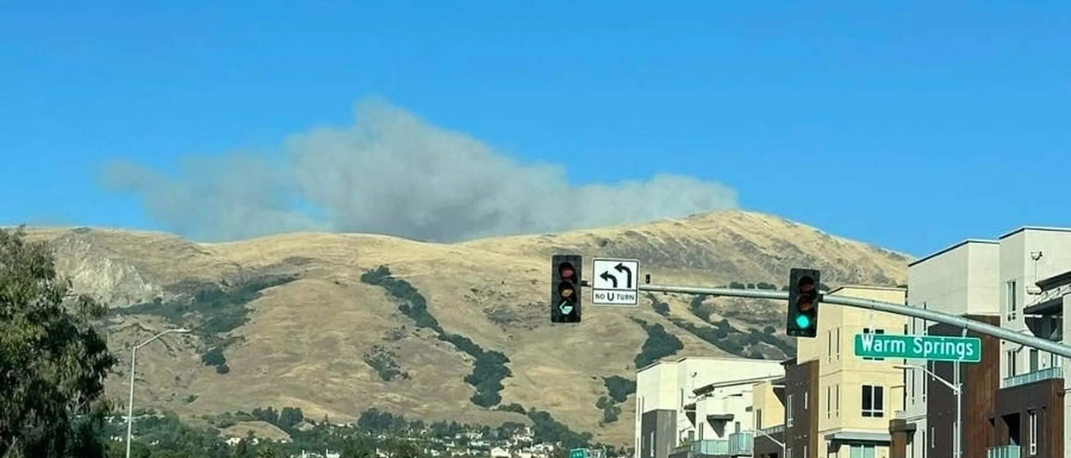
Fremont's eastern foothills along Mission Peak and Niles Canyon experience grass fires that can reach residential areas within minutes.
FireRoofs Premier Home Hardening & Active Defense
FireRoofs provides premier wildfire defense and home hardening for Fremont properties. We combine automated exterior sprinkler systems with structural hardening that addresses every ember entry point on the home.
Automated Exterior Sprinklers
Dual-detection roof and perimeter sprinklers with satellite monitoring
Ember-Resistant Vents
Retrofit vents that seal the attic from ember intrusion
Noncombustible Fencing
Eliminate the fence-to-structure flame path
Zone Zero Hardening
Clear combustible material within 5 feet of the structure
Vegetation Fire Retardant
Applied to surrounding landscape for ember resistance
Insurance Evidence Packet
Mapped to California Regulation 2644.9 for carrier submission
Fremont stretches from the Bay to Mission Peak and the Sunol Ridge, with residential neighborhoods in the Niles, Mission San Jose, and Warm Springs areas facing direct wildfire exposure from grassland-covered hills. The 2019 Marsh Fire and ongoing vegetation fire starts demonstrate the active fire risk. FireRoofs provides hardening for Fremont homes where suburban development interfaces with East Bay wildland.
EmberSafe Gutter Guard Installation in Fremont
Fremont hillside homes near Mission Peak and Sunol Ridge collect dry grass, oak leaf, and fine debris in gutters that become flashpoint fuel during fire weather. Our stainless steel micro mesh gutter guards maintain noncombustible gutter lines year-round, protecting the roof edge from ember-driven ignition. This is one of the most impactful and cost-effective hardening measures for Fremont WUI properties.
Fire Safe Marin - Fire-Resistant GuttersVulcan Vents Ember-Resistant Vent Retrofit in Fremont
Fremont homes facing the East Bay hills are exposed to wind-driven embers from grassland fires. Legacy vent configurations on older construction offer no meaningful ember protection. Vulcan Vents with ASTM E2886 certification provide stainless steel ember mesh and intumescent sealing that blocks both embers and direct flame, meeting the California Building Code Chapter 7A vent standards for Fremont fire hazard zones.
Vulcan Vents - WUI Code ComplianceNon Combustible Fencing for Fremont Hillside Properties
Wood fencing along Fremont's hillside neighborhoods creates fire pathways from grassland to structures. Our noncombustible fencing replaces combustible wood sections within 5 feet of the home with steel or aluminum panels meeting ASTM E136 standards. This Zone 0 compliance measure is critical for Fremont homes near Mission Peak and Sunol Ridge where grass fires can reach residential areas rapidly.
Ready for Wildfire - Defensible Space GuideLandscape Fuelbreak for Fremont WUI Properties
Fremont properties at the urban-wildland edge often have dried ornamental plantings, bark mulch, and grass extending to the foundation. Our noncombustible fuelbreak replaces these materials within the Zone 0 perimeter with gravel or hardscape, creating the ember-resistant zone AB 3074 requires. For Fremont homes exposed to fast-moving grass fire, this eliminates the most accessible ignition fuel at the building foundation.
Board of Forestry - Zone 0 StandardsOpen Eave Enclosure for Fremont Homes
Fremont homes built during the city's expansion era commonly have open eave construction that predates WUI standards. Wind-driven embers from hillside fires enter these openings and ignite attic materials. Our eave enclosure retrofit installs noncombustible soffit material with ASTM E2886-rated vents, converting open eaves to the enclosed configuration that Chapter 7A requires for wildfire-exposed construction.
CALBO - Chapter 7A StandardsWhy Home Hardening Matters in Fremont
Fremont’s fire-zone neighborhoods along Mission Hills and Niles Canyon face the same insurance and risk challenges as every other Bay Area WUI community
FireRoofs provides automated sprinkler systems and full-spectrum hardening for these properties, with documentation formatted for carrier review.

CAL FIRE Very High Fire Hazard Severity Zones (VHFHSZ) shown in red/orange
Source: CAL FIRE Fire Hazard Severity Zone data via Bay Area News Group
CAL FIRE High Fire Hazard Severity Zone
Portions of Fremont fall within CAL FIRE's Very High Fire Hazard Severity Zone, concentrated along the eastern hills from Mission Peak south to the Sunol border.
Fremont's Wildfire Record
Understanding past fires helps predict future risk. Here are the most significant fire events near Fremont.
Burned 396,625 acres in nearby counties, triggering evacuation warnings for Fremont's eastern hillside communities.
Multiple grass fires burned in Fremont's eastern hills and Coyote Hills area during Red Flag Warning conditions.
While centered north, the fires demonstrated the catastrophic potential of Diablo wind-driven fires for all East Bay communities.
Local Risk Factors
Mission Peak WUI Exposure
Thousands of homes in the Mission San Jose and Warm Springs neighborhoods are built against the steep Mission Peak foothills, with dry grassland extending to property lines.
Diablo Wind Corridor
Fremont's eastern hills are directly in the path of hot, dry Diablo winds that funnel through Niles Canyon and Sunol Valley, creating extreme fire weather.
Grassland Fire Risk
Annual grasslands on the eastern hills cure to tinder-dry conditions by June, creating fast-moving fire risk that can reach homes in minutes.
Water Supply Limitations
Hillside areas rely on gravity-fed water systems that may not provide adequate pressure during large-scale fire suppression.
Book a free on-site evaluation. We will design and install the right sprinkler and hardening system for your home.
Book Free EvaluationGet the $149 assessment report. Find out what wildfire risk models flag on your property. Results in minutes.
Get $149 ReportFremont Fire Environment
Vegetation Types
Wind Patterns
Diablo winds (NE) in fall funneling through Niles Canyon; bay breeze (W) in summer
Topography
Elevation ranges from sea level at the bay to 2,500 ft at Mission Peak. Steep west-facing slopes create direct fire exposure for hillside neighborhoods.
Fire District
Fremont Fire Department, multiple stations
Insurance Impact
Fremont hillside properties are increasingly seeing insurance non-renewals, particularly in Mission San Jose and Warm Springs neighborhoods adjacent to open space.
Protecting Your Fremont Home & Family
Living in a fire-prone area means being proactive. Here are the steps every Fremont homeowner should take to protect their property and prepare for wildfire season.
Evacuation Planning
Fremont's eastern hillside neighborhoods have limited exit routes that feed onto Mission Blvd and I-680. Register for AC Alert (Alameda County) and know multiple routes to I-880 or Highway 84. Don't rely on a single road. Niles Canyon closes during fires.
Defensible Space
Fremont requires defensible space compliance in VHFHSZ areas. The Diablo Fire Safe Council offers up to $3,500 in cost-sharing for vegetation clearing. Keep grass below 4 inches within 30 feet of structures and create a non-combustible zone within 5 feet of your home.


Your Local Fire Safe Council
Diablo Fire Safe Council
The Diablo Fire Safe Council offers free resources, community chipping programs, home assessments, and education to help Fremont residents reduce wildfire risk and prepare for fire season.
Visit Diablo Fire Safe CouncilFremont Wildfire Preparedness Resources
Diablo Fire Safe Council
Up to $3,500 in cost-sharing for vegetation clearing, Firewise community support, and education programs for Alameda County residents.
Diablo FSCFremont Wildfire Preparedness
City of Fremont wildfire preparedness information, VHFHSZ maps, and defensible space requirements.
City of FremontCAL FIRE Defensible Space Guide
Official California guide to creating defensible space zones around your property.
CAL FIREProtect Your Fremont Home with FireRoofs
Defensible space and evacuation planning are essential, but they have limits. When embers are raining down and flames are approaching, your home needs both an automated active defense system and structural hardening that eliminates every ember entry point.
FireRoofs combines automated exterior sprinkler systems with structural home hardening for Fremont properties. Our Detect → Alert → Defend system uses intelligent wildfire detection cameras, satellite monitoring, and high-pressure water to saturate your property. Our hardening scope seals every vulnerability embers exploit.
- Automated exterior sprinklers: roof and perimeter coverage with dual detection
- Ember-resistant vent retrofits to seal the attic from intrusion
- Noncombustible fencing to eliminate the fence-to-structure flame path
- Zone Zero landscape hardening within 5 feet of the structure
- Vegetation fire retardant application for surrounding landscape
- Class A firefighting foam add-on: 100% biodegradable, non-toxic, rinses off through sprinklers
- Insurance evidence packet documenting all upgrades, mapped to California Regulation 2644.9


Local Wildfire Resources for Fremont Homeowners
Rules and requirements can change. Verify current requirements with your city or fire district before taking action.

Tree Removal and Defensible Space Rules
City tree removal permits with fire hazard exemptions. Follows PRC 4291 for defensible space.
Fire Hazard Severity Zone: Very High in Mission Peak and hillside areas. Local Responsibility Area.

Free Programs for Fremont Homeowners
- SCCFD/Fremont Fire vegetation management programs

Statewide Zone 0 Compliance Timeline
Board of Forestry rulemaking targeted for completion by December 31, 2025. New construction: compliance begins once rules are adopted (projected 2026). Existing structures: 3-year phase-in (compliance expected by approximately 2028-2029).
State Defensible Space (PRC 4291)
Zone 0: 0-5 feet, ember-resistant/noncombustible. Zone 1: 5-30 feet, lean, clean, and green. Zone 2: 30-100 feet, reduced fuel loading. Annual compliance inspections by local fire districts during fire season.
California Building Code
Effective 2026, California Wildland-Urban Interface Code (CWUIC) Part 7 replaces CBC Chapter 7A. Applies to new construction in designated fire hazard zones.
How FireRoofs Fits In
Understanding your local requirements is the first step. A FireRoofs automated defense system works alongside your defensible space, home hardening, and community efforts to give your home the strongest possible protection. During your free property evaluation, our team reviews your property in the context of Fremont's specific requirements and helps you understand how active defense fits into your overall wildfire strategy.
Nearby Communities We Serve
FireRoofs also installs wildfire defense systems in neighboring communities with similar WUI risk profiles.
2026 Insurance Alert for Fremont Homeowners
Homeowners in Fremont are facing surging FAIR Plan rates and non-renewals from private carriers. California's Safer from Wildfires framework now requires participating insurers to offer discounts for documented mitigation systems. FireRoofs provides the engineering documentation and evidence packet designed to help you qualify for the voluntary market.
California's SB 429 (effective January 1, 2026) establishes the nation's first public wildfire catastrophe model, giving homeowners new tools to understand insurance risk scores. Ask HydroIQ what this means for Fremont homeowners.
Request a Free Property EvaluationAsk HydroIQ About Fremont - Free AI Wildfire Assistant
Get instant answers about Fremont's wildfire risk level, defensible space requirements, fire history, FAIR Plan insurance options, and how exterior sprinkler systems can protect your home. HydroIQ covers communities across all nine Bay Area counties.
Protect Your Fremont Property Today
Every Fremont property is different. Get a free evaluation of your home's wildfire exposure and a custom defense plan.
Common Questions
What wildfire risk does Fremont face?
Fremont is designated a High fire risk zone by CAL FIRE. Alameda County fire maps confirm elevated exposure driven by annual grassland and chaparral fuel loads and dry-season wind patterns. Thousands of homes in the Mission San Jose and Warm Springs neighborhoods are built against the steep Mission Peak foothills, with dry grassland extending to property lines.
How does FireRoofs protect Fremont homes from wildfire?
FireRoofs provides both active defense and passive home hardening for Fremont properties. Active defense includes automated exterior sprinkler systems with dual detection, satellite monitoring, and intelligent fire detection cameras. Passive hardening covers ember-resistant vent retrofits, noncombustible fencing, Zone Zero landscape hardening, exterior cladding upgrades, and vegetation fire retardant. Every upgrade is documented in one evidence packet mapped to California Regulation 2644.9 for insurance recognition.
What does home hardening include for a Fremont property?
Home hardening for Fremont properties addresses every ember entry point on the structure. FireRoofs performs ember-resistant vent installation, noncombustible fencing replacement, eave and soffit sealing, Zone Zero landscape clearance within 5 feet of the structure, vegetation fire retardant application, and exterior cladding upgrades where needed. Scope is determined during a free property evaluation and accounts for local terrain and elevation changes. All work is documented for insurance submission.
Where can I get instant answers about Fremont's wildfire risk?
HydroIQ is FireRoofs' free wildfire assistant that provides instant, city-specific answers about Fremont's fire hazard zone classification, defensible space requirements, local fire history, FAIR Plan insurance options, and wildfire defense systems. No sign-up required. Visit fireroofs.com/hydroiq to learn more or ask a question directly.
What is California home hardening?
California home hardening is the process of retrofitting a structure to resist wildfire ember intrusion and radiant heat exposure. It includes replacing combustible building materials, sealing openings such as attic vents and eaves, installing noncombustible fencing, clearing the Zone Zero perimeter within 5 feet of the structure, and applying fire-resistant treatments. Home hardening is one of the 12 mitigation categories under California Regulation 2644.9 (Safer from Wildfires) that participating insurers must recognize when setting premiums.
How do I get off the California FAIR Plan?
To transition from the California FAIR Plan back to the voluntary insurance market, homeowners need to demonstrate documented wildfire risk reduction. This includes property-level mitigation such as home hardening, automated exterior sprinkler systems, and defensible space maintenance. Under California Regulation 2644.9, admitted insurers are required to offer premium discounts for documented mitigation across 12 categories. FireRoofs provides the upgrades and the evidence packet that documents each improvement for your insurer or broker.
What are the 12 Safer from Wildfires mitigation categories?
California Regulation 2644.9 defines 12 mitigation categories that insurers must recognize: (1) Class A fire-rated roof, (2) Enclosed eaves, (3) Ember-resistant vents, (4) Exterior wall cladding, (5) Dual-pane or tempered windows, (6) Noncombustible fencing within 5 feet, (7) Defensible space Zone 0-2 maintained, (8) Community-level mitigation (Fire Risk Reduction Community), (9) Active fire defense system such as exterior sprinklers, (10) Fire-resistant landscaping, (11) Access and water supply, (12) Structure-specific risk reduction. FireRoofs addresses categories 1 through 10 directly.
Do exterior roof sprinklers qualify for insurance discounts in California?
Yes. Automated exterior sprinkler systems are recognized under Category 9 (Active Fire Defense System) of California Regulation 2644.9. When documented in an evidence packet and submitted to your insurer, they count toward the mitigation credits that admitted carriers are required to apply. FireRoofs installs dual-detection exterior sprinkler systems and provides the documentation package for insurance recognition. SB 429 (effective January 1, 2026) further supports this by establishing a public wildfire catastrophe model that factors documented improvements into risk scoring.
What wildfire defense rules apply in Fremont?
Fremont follows state PRC 4291 defensible space requirements. City tree removal permits include fire hazard exemptions for hillside properties. Contact Fremont Fire Department for current vegetation management programs.