Portola Valley Wildfire Defense
Portola Valley is 7.5 square miles of open space preserves, horse ranches, and estate homes at the intersection of three major fire corridors. Coal Creek, Windy Hill, and Russian Ridge preserves border the town on three sides with thousands of acres of unmanaged grassland and oak woodland. Every summer, that grass dries to tinder by mid-June. In 2022, a vegetation fire on Alpine Road forced evacuations of The Sequoias retirement community and demonstrated how quickly fire moves through the annual grassland that surrounds most of Portola Valley's 1,650 homes.
$149 Wildfire Report for Portola Valley Homeowners
See what California wildfire codes require for your Portola Valley property. Covers roof, vents, defensible space, and insurance paperwork. Get your report in minutes.
CAL FIRE Risk Designation
San Mateo County
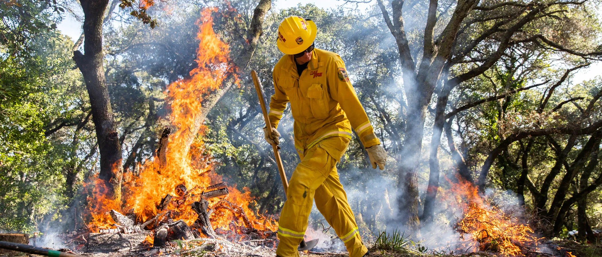
Portola Valley is bordered by thousands of acres of open space preserves, with dry grassland reaching the edge of residential properties.
FireRoofs Premier Home Hardening & Active Defense
FireRoofs provides premier wildfire defense and home hardening for Portola Valley properties. We combine automated exterior sprinkler systems with structural hardening that addresses every ember entry point on the home.
Automated Exterior Sprinklers
Dual-detection roof and perimeter sprinklers with satellite monitoring
Ember-Resistant Vents
Retrofit vents that seal the attic from ember intrusion
Noncombustible Fencing
Eliminate the fence-to-structure flame path
Zone Zero Hardening
Clear combustible material within 5 feet of the structure
Vegetation Fire Retardant
Applied to surrounding landscape for ember resistance
Insurance Evidence Packet
Mapped to California Regulation 2644.9 for carrier submission
Portola Valley is one of the most fire-vulnerable communities on the San Francisco Peninsula, with nearly all residential areas falling within VHFHSZ zones. Properties are nestled among coast live oak, bay laurel, and grassland on steep hillsides with single-lane access roads. The combination of dense vegetation, limited egress, and aging construction demands comprehensive structural hardening.
EmberSafe Gutter Guard Installation in Portola Valley
Portola Valley homes sit within a thick oak and bay laurel canopy that produces continuous leaf and twig litter in gutters. During fall offshore wind events, embers can travel miles and ignite debris-packed gutters instantly. Our stainless steel micro mesh guards eliminate gutter fuel loads while withstanding the corrosive tannins from oak runoff that degrade lesser materials.
Fire Safe San Mateo - Home HardeningVulcan Vents Vent Retrofit for Portola Valley Homes
Portola Valley properties built before the 2008 WUI code updates commonly have vents with 1/4-inch mesh that fails to stop embers. Research shows embers passing through even 1/8-inch screening can ignite attic insulation. Vulcan Vents combine fine stainless steel mesh with intumescent honeycomb technology, exceeding the ASTM E2886 standard now required under California Building Code Chapter 7A for VHFHSZ construction.
Fire Safe San Mateo - Vent ProtectionNon Combustible Deck Retrofit in Portola Valley
Portola Valley mountain homes rely on expansive decks for outdoor living and views, but aging wood decking creates one of the largest combustible surfaces exposed to embers. Our retrofit replaces existing decking with products that pass the SFM Standard 12-7A-4 fire test, which subjects materials to an 80 kW under-deck flame for 3 minutes. The result eliminates the ignition risk while maintaining the natural look Portola Valley homeowners prefer.
Fire Safe San Mateo - Deck HardeningOpen Eave Enclosure in Portola Valley
Many Portola Valley homes feature mid-century or ranch-style architecture with open eave detailing that exposes rafter tails and fascia to ember intrusion. This construction style predates all WUI building codes. Our retrofit encloses open eaves with noncombustible soffit panels and installs California State Fire Marshal-listed vents to maintain proper attic ventilation without creating new ember entry points.
CALBO - Chapter 7A Code UpdatesLandscape-to-Structure Fuelbreak in Portola Valley
Portola Valley landscaping often extends native vegetation and bark mulch directly to the foundation, violating AB 3074 Zone 0 requirements. Our fuelbreak installation removes combustible materials within 5 feet of the structure and replaces them with noncombustible hardscape. For Portola Valley slopes, we design graded drainage solutions that prevent erosion while eliminating the ember ignition pathway at the building perimeter.
Board of Forestry - Zone 0 RequirementsWhy Home Hardening Matters in Portola Valley
When three borders are wildland and the town is fully VHFHSZ, every mitigation category matters. Portola Valley homeowners need both active defense that stops fire at the property line and physical hardening that removes every ember entry point on the structure. FireRoofs builds systems for Portola Valley’s terrain: steep lots, dense canopy, variable water pressure, and multiple structures
We pair the sprinkler installation with the full hardening scope, and the evidence packet documents everything for insurance purposes. For Portola Valley homeowners facing the highest FAIR Plan rates in the county, documented mitigation is not optional. It is the path back to the voluntary insurance market.

CAL FIRE Very High Fire Hazard Severity Zones (VHFHSZ) shown in red/orange
Source: CAL FIRE Fire Hazard Severity Zone data via Bay Area News Group
CAL FIRE VHFHSZ Designation
Significant portions of Portola Valley are designated VHFHSZ by CAL FIRE, with risk concentrated along the western ridge and throughout areas bordering open space preserves.
Portola Valley's Wildfire Record
Understanding past fires helps predict future risk. Here are the most significant fire events near Portola Valley.
Evacuation warnings issued for parts of Portola Valley as fire burned in nearby Santa Cruz Mountains.
Grassland fire burned hundreds of acres of open space adjacent to residential areas.
Fire along Skyline Blvd threatened the watershed and nearby residential properties.
Local Risk Factors
Open Space Preserve Borders
The town is bordered by Windy Hill, Coal Creek, and Russian Ridge preserves. That's thousands of acres of unmanaged wildland fuel.
Grassland Fire Risk
Annual grass dries completely by June, creating fast-spreading surface fires that can reach structures in minutes.
Ridge-Top Wind Exposure
Properties along Skyline Blvd and Alpine Road are exposed to strong ridgeline winds that accelerate fire spread.
Aging Infrastructure
Many properties rely on older water systems and narrow access roads not designed for modern fire response.
Book a free on-site evaluation. We will design and install the right sprinkler and hardening system for your home.
Book Free EvaluationGet the $149 assessment report. Find out what wildfire risk models flag on your property. Results in minutes.
Get $149 ReportPortola Valley Fire Environment
Vegetation Types
Wind Patterns
Strong ridgeline winds; offshore wind events create extreme conditions
Topography
Elevation 200-2,000 ft. Rolling hills and steep ridgelines.
Fire District
Woodside Fire Protection District, Portola Valley Station
Insurance Impact
Portola Valley homeowners face among the highest FAIR Plan enrollment rates in San Mateo County due to widespread insurer withdrawals.
Protecting Your Portola Valley Home & Family
Living in a fire-prone area means being proactive. Here are the steps every Portola Valley homeowner should take to protect their property and prepare for wildfire season.
Evacuation Planning
Portola Valley has 13 emergency gates connecting streets that open during evacuations. Know your Zonehaven zone, register for SMC Alert, and identify which emergency gate is nearest your home. The town recommends leaving early. evacuations are issued conservatively.
Defensible Space
Portola Valley requires non-combustible fencing, decks, and siding within the home ignition zone. Participate in the town Chipper Days program to dispose of hazardous vegetation. Trim tree branches 10 feet from chimneys and rooflines.


Your Local Fire Safe Council
Fire Safe San Mateo County
The Fire Safe San Mateo County offers free resources, community chipping programs, home assessments, and education to help Portola Valley residents reduce wildfire risk and prepare for fire season.
Visit Fire Safe San Mateo CountyPortola Valley Wildfire Preparedness Resources
Portola Valley Wildfire Preparedness
Official town resource with evacuation plans, vegetation management programs, and emergency gate locations.
Town of Portola ValleyFire Safe San Mateo County
Chipper programs, home hardening resources, and community wildfire protection planning.
Fire Safe San MateoFire Safe San Mateo Programs
Chipper programs, home hardening resources, and community wildfire protection for San Mateo County.
Fire Safe San MateoProtect Your Portola Valley Home with FireRoofs
Defensible space and evacuation planning are essential, but they have limits. When embers are raining down and flames are approaching, your home needs both an automated active defense system and structural hardening that eliminates every ember entry point.
FireRoofs combines automated exterior sprinkler systems with structural home hardening for Portola Valley properties. Our Detect → Alert → Defend system uses intelligent wildfire detection cameras, satellite monitoring, and high-pressure water to saturate your property. Our hardening scope seals every vulnerability embers exploit.
- Automated exterior sprinklers: roof and perimeter coverage with dual detection
- Ember-resistant vent retrofits to seal the attic from intrusion
- Noncombustible fencing to eliminate the fence-to-structure flame path
- Zone Zero landscape hardening within 5 feet of the structure
- Vegetation fire retardant application for surrounding landscape
- Class A firefighting foam add-on: 100% biodegradable, non-toxic, rinses off through sprinklers
- Insurance evidence packet documenting all upgrades, mapped to California Regulation 2644.9


Local Wildfire Resources for Portola Valley Homeowners
Rules and requirements can change. Verify current requirements with your city or fire district before taking action.

Tree Removal and Defensible Space Rules
Permits required for trees over 12 inches diameter. Exemptions for defensible space. WFPD Ordinance 24-01 applies. Town executing multiyear vegetation management program along primary evacuation routes.
Fire Hazard Severity Zone: Very High. Local Responsibility Area.

Free Programs for Portola Valley Homeowners
- WFPD chipper program

Statewide Zone 0 Compliance Timeline
Board of Forestry rulemaking targeted for completion by December 31, 2025. New construction: compliance begins once rules are adopted (projected 2026). Existing structures: 3-year phase-in (compliance expected by approximately 2028-2029).
State Defensible Space (PRC 4291)
Zone 0: 0-5 feet, ember-resistant/noncombustible. Zone 1: 5-30 feet, lean, clean, and green. Zone 2: 30-100 feet, reduced fuel loading. Annual compliance inspections by local fire districts during fire season.
California Building Code
Effective 2026, California Wildland-Urban Interface Code (CWUIC) Part 7 replaces CBC Chapter 7A. Applies to new construction in designated fire hazard zones.
How FireRoofs Fits In
Understanding your local requirements is the first step. A FireRoofs automated defense system works alongside your defensible space, home hardening, and community efforts to give your home the strongest possible protection. During your free property evaluation, our team reviews your property in the context of Portola Valley's specific requirements and helps you understand how active defense fits into your overall wildfire strategy.
Nearby Communities We Serve
FireRoofs also installs wildfire defense systems in neighboring communities with similar WUI risk profiles.
2026 Insurance Alert for Portola Valley Homeowners
Homeowners in Portola Valley are facing surging FAIR Plan rates and non-renewals from private carriers. California's Safer from Wildfires framework now requires participating insurers to offer discounts for documented mitigation systems. FireRoofs provides the engineering documentation and evidence packet designed to help you qualify for the voluntary market.
California's SB 429 (effective January 1, 2026) establishes the nation's first public wildfire catastrophe model, giving homeowners new tools to understand insurance risk scores. Ask HydroIQ what this means for Portola Valley homeowners.
Request a Free Property EvaluationAsk HydroIQ About Portola Valley - Free AI Wildfire Assistant
Get instant answers about Portola Valley's wildfire risk level, defensible space requirements, fire history, FAIR Plan insurance options, and how exterior sprinkler systems can protect your home. HydroIQ covers communities across all nine Bay Area counties.
Protect Your Portola Valley Property Today
Every Portola Valley property is different. Get a free evaluation of your home's wildfire exposure and a custom defense plan.
Common Questions
What wildfire risk does Portola Valley face?
Portola Valley is designated a Very High Fire Hazard Severity Zone by CAL FIRE. San Mateo County fire maps confirm extreme exposure driven by annual grassland and coast live oak fuel loads and seasonal offshore winds. The town is bordered by Windy Hill, Coal Creek, and Russian Ridge preserves. That's thousands of acres of unmanaged wildland fuel.
How does FireRoofs protect Portola Valley homes from wildfire?
FireRoofs provides both active defense and passive home hardening for Portola Valley properties. Active defense includes automated exterior sprinkler systems with dual detection, satellite monitoring, and intelligent fire detection cameras. Passive hardening covers ember-resistant vent retrofits, noncombustible fencing, Zone Zero landscape hardening, exterior cladding upgrades, and vegetation fire retardant. Every upgrade is documented in one evidence packet mapped to California Regulation 2644.9 for insurance recognition.
What does home hardening include for a Portola Valley property?
Home hardening for Portola Valley properties addresses every ember entry point on the structure. FireRoofs performs ember-resistant vent installation, noncombustible fencing replacement, eave and soffit sealing, Zone Zero landscape clearance within 5 feet of the structure, vegetation fire retardant application, and exterior cladding upgrades where needed. Scope is determined during a free property evaluation and accounts for local terrain and elevation changes. All work is documented for insurance submission.
Where can I get instant answers about Portola Valley's wildfire risk?
HydroIQ is FireRoofs' free wildfire assistant that provides instant, city-specific answers about Portola Valley's fire hazard zone classification, defensible space requirements, local fire history, FAIR Plan insurance options, and wildfire defense systems. No sign-up required. Visit fireroofs.com/hydroiq to learn more or ask a question directly.
What is California home hardening?
California home hardening is the process of retrofitting a structure to resist wildfire ember intrusion and radiant heat exposure. It includes replacing combustible building materials, sealing openings such as attic vents and eaves, installing noncombustible fencing, clearing the Zone Zero perimeter within 5 feet of the structure, and applying fire-resistant treatments. Home hardening is one of the 12 mitigation categories under California Regulation 2644.9 (Safer from Wildfires) that participating insurers must recognize when setting premiums.
How do I get off the California FAIR Plan?
To transition from the California FAIR Plan back to the voluntary insurance market, homeowners need to demonstrate documented wildfire risk reduction. This includes property-level mitigation such as home hardening, automated exterior sprinkler systems, and defensible space maintenance. Under California Regulation 2644.9, admitted insurers are required to offer premium discounts for documented mitigation across 12 categories. FireRoofs provides the upgrades and the evidence packet that documents each improvement for your insurer or broker.
What are the 12 Safer from Wildfires mitigation categories?
California Regulation 2644.9 defines 12 mitigation categories that insurers must recognize: (1) Class A fire-rated roof, (2) Enclosed eaves, (3) Ember-resistant vents, (4) Exterior wall cladding, (5) Dual-pane or tempered windows, (6) Noncombustible fencing within 5 feet, (7) Defensible space Zone 0-2 maintained, (8) Community-level mitigation (Fire Risk Reduction Community), (9) Active fire defense system such as exterior sprinklers, (10) Fire-resistant landscaping, (11) Access and water supply, (12) Structure-specific risk reduction. FireRoofs addresses categories 1 through 10 directly.
Do exterior roof sprinklers qualify for insurance discounts in California?
Yes. Automated exterior sprinkler systems are recognized under Category 9 (Active Fire Defense System) of California Regulation 2644.9. When documented in an evidence packet and submitted to your insurer, they count toward the mitigation credits that admitted carriers are required to apply. FireRoofs installs dual-detection exterior sprinkler systems and provides the documentation package for insurance recognition. SB 429 (effective January 1, 2026) further supports this by establishing a public wildfire catastrophe model that factors documented improvements into risk scoring.
What defensible space rules apply in Portola Valley?
Portola Valley is covered by WFPD Ordinance 24-01, which mandates fuel mitigation with annual inspections. Tree removal permits are required for trees over 12 inches diameter, with exemptions for defensible space. The town is also executing a multiyear vegetation management program along primary evacuation routes.
Are there free wildfire programs for Portola Valley?
Yes. The Woodside Fire Protection District offers a chipper program for VHFHSZ residents. Stanford University and Mid-Peninsula Regional Open Space District also conduct vegetation management on adjacent properties.