Atherton Wildfire Defense
Atherton is one of the most expensive ZIP codes in America (94027), but its fire risk is not driven by proximity to open wildland. It is driven by what grows on the properties themselves. Atherton's 2,000 homes sit under a dense, mature tree canopy of coast live oak, redwood, and eucalyptus that the town actively protects through heritage tree ordinances. During a Diablo wind event, embers from fires in the Woodside or Portola Valley hills could travel 1-2 miles downwind and land in that canopy. The combination of large wood-frame estates, extensive landscaping, and a tree canopy that holds and redistributes embers makes Atherton an ember-reception zone even though it sits on relatively flat terrain.
$149 Wildfire Report for Atherton Homeowners
See what California wildfire codes require for your Atherton property. Covers roof, vents, defensible space, and insurance paperwork. Get your report in minutes.
CAL FIRE Risk Designation
San Mateo County
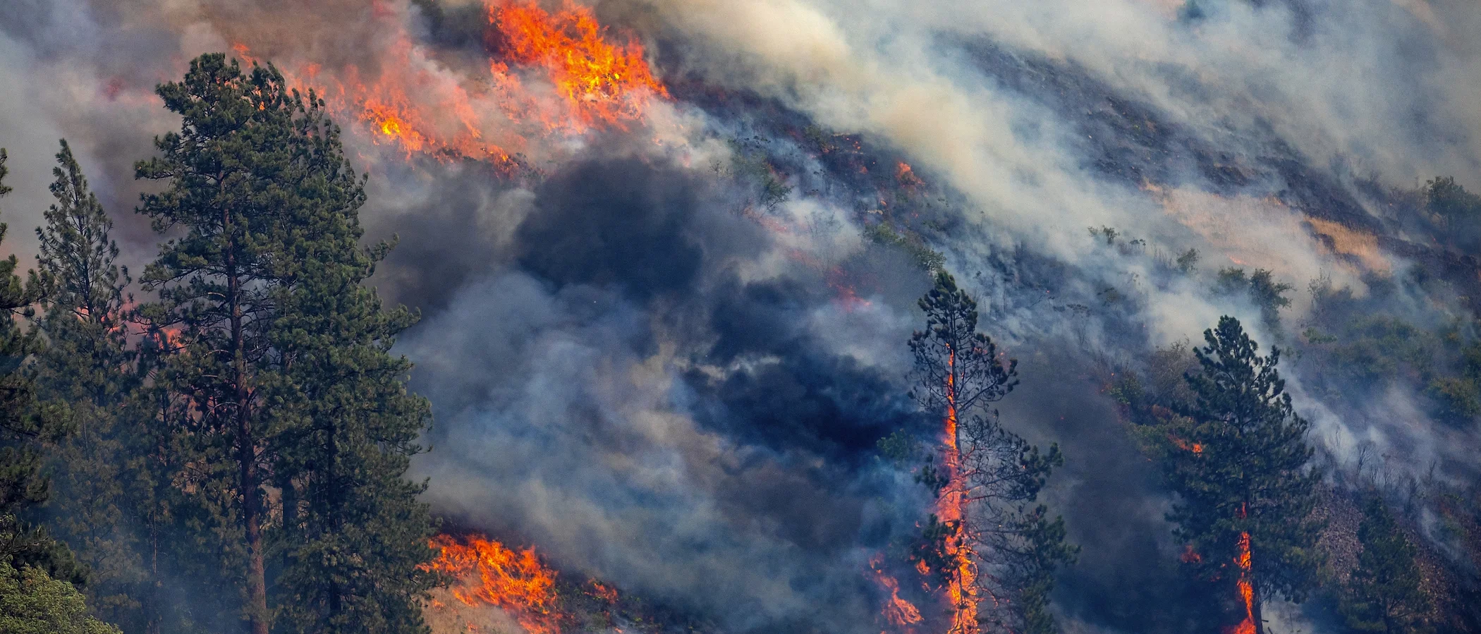
Atherton's dense heritage tree canopy turns the town into an ember-reception zone during wind events, even though it sits on flat terrain miles from wildland.
FireRoofs Premier Home Hardening & Active Defense
FireRoofs provides premier wildfire defense and home hardening for Atherton properties. We combine automated exterior wildfire sprinkler systems with structural hardening that addresses every ember entry point on the home. Learn more about wildfire roof sprinkler installation and how it works alongside defensible space in Atherton.
Automated Exterior Sprinklers
Dual-detection roof and perimeter sprinklers with satellite monitoring
Ember-Resistant Vents
Retrofit vents that seal the attic from ember intrusion
Noncombustible Fencing
Eliminate the fence-to-structure flame path
Zone Zero Hardening
Clear combustible material within 5 feet of the structure
Vegetation Fire Retardant
Applied to surrounding landscape for ember resistance
Insurance Evidence Packet
Mapped to California Regulation 2644.9 for carrier submission
Atherton is characterized by large estate properties under dense tree canopy, with proximity to wildland areas along the western foothills. The combination of mature vegetation, expansive lot sizes, and older construction makes Atherton properties vulnerable to ember intrusion and radiant heat exposure during wildfire events. FireRoofs provides discreet, high-quality hardening retrofits appropriate for Atherton's estate-level properties.
Ember-Resistant Vent Retrofit for Atherton Estates
Atherton estates with expansive roof lines have numerous vent openings that create multiple ember entry points. Our Vulcan Vents retrofit covers all vent types, from foundation to ridge, with ASTM E2886-certified assemblies that block embers and seal under fire conditions. For Atherton properties, we coordinate vent upgrades across the entire structure to eliminate every opening that could allow ember intrusion.
Vulcan Vents - California ComplianceStainless Steel Micro Mesh Gutter Guards for Atherton
Atherton's mature oak, redwood, and eucalyptus canopy produces extraordinary debris loads in gutters. Large roof areas collect correspondingly large amounts of combustible material along their edges. Our surgical-grade stainless steel micro mesh gutter guards are sized and installed for the extensive gutter runs typical of Atherton estates, preventing debris accumulation that would otherwise create continuous fire risk along the roof perimeter.
Fire Safe San Mateo - Home Hardening GuideLandscape-to-Structure Fuelbreak for Atherton Properties
Atherton properties feature elaborate landscaping with bark mulch, ornamental plantings, and organic ground covers extending to the foundation. While aesthetically beautiful, this creates a combustible pathway from landscape to structure. Our fuelbreak replaces combustible materials within the Zone 0 perimeter with noncombustible alternatives designed to complement Atherton's estate landscaping while meeting AB 3074 requirements.
Board of Forestry - Zone 0 StandardsNon Combustible Fencing for Atherton Estates
Atherton properties often have extensive wood fencing along property boundaries and garden enclosures. This combustible fencing can carry fire from neighboring lots or wildland directly to the structure. Our noncombustible fencing installation uses high-quality aluminum, steel, or masonry materials matching the design standards Atherton homeowners expect, while meeting ASTM E136 noncombustibility standards for Zone 0 compliance.
Ready for Wildfire - Defensible SpaceUnder Deck Enclosure for Atherton Properties
Atherton estates frequently have elevated deck and patio structures with open undersides that collect debris from surrounding tree canopy. Our noncombustible under deck enclosure uses metal screening or fiber-cement panels to seal these spaces while maintaining proper ventilation. For large Atherton deck structures, this treatment prevents the debris-trap fire pathway that is a primary cause of deck-to-structure fire transfer.
Fire Safe Marin - Deck Fire ProtectionWhy Home Hardening Matters in Atherton
When your property is worth $10M or more and your insurance cap is $3M, the financial case for mitigation is clear. Documented hardening and active defense give surplus lines carriers a reason to write coverage they would otherwise decline
FireRoofs designs systems for Atherton’s large estate lots, addressing both the sprinkler coverage needed for the structures and the hardening upgrades needed for the grounds: noncombustible fencing, Zone Zero clearance, vegetation treatment, and ember-resistant vent replacement. The evidence packet documents everything at the level surplus lines underwriters expect.

CAL FIRE Very High Fire Hazard Severity Zones (VHFHSZ) shown in red/orange
Source: CAL FIRE Fire Hazard Severity Zone data via Bay Area News Group
CAL FIRE High Fire Hazard Severity Zone
Portions of Atherton fall within High FHSZ due to dense tree canopy. Local Responsibility Area. Updated per 2025 CAL FIRE maps. Risk is primarily ember-driven rather than direct flame contact.
Atherton's Wildfire Record
Understanding past fires helps predict future risk. Here are the most significant fire events near Atherton.
No major wildfire has burned into Atherton in recent decades. However, proximity to Menlo Park and Woodside means the town experiences smoke and ember exposure during regional fire events in the Peninsula foothills.
Local Risk Factors
Dense Mature Tree Canopy
Extensive heritage oak, redwood, and ornamental tree canopy throughout the town creates significant ember-catching potential during major fire events.
Upwind Wildland Exposure
Adjacent to Menlo Park and Woodside, which have significant WUI. Embers from Peninsula foothill fires could travel into Atherton during offshore wind events.
Extreme Property Values
Median home values exceed $7M-$10M with many properties $20M+. Virtually every property exceeds the $3M FAIR Plan cap, creating massive underinsurance gaps.
Heritage Tree Ordinance
Strict heritage tree protections can complicate vegetation management for defensible space, though exemptions exist for fire hazard risk.
Book a free on-site evaluation. We will design and install the right sprinkler and hardening system for your home.
Book Free EvaluationAll work performed by licensed and insured contractors.
Get the $149 assessment report. Find out what wildfire risk models flag on your property. Results in minutes.
Get $149 ReportAtherton Fire Environment
Vegetation Types
Wind Patterns
Moderate Diablo wind exposure; wind shadow of Santa Cruz Mountains with spillover wind and ember risk from Peninsula foothills
Topography
Largely flat to gently rolling terrain on the Peninsula bayside of I-280. Unlike foothill cities, Atherton's fire risk is ember-driven rather than terrain-driven.
Fire District
Menlo Park Fire Protection District
Insurance Impact
Atherton consistently ranks among the most expensive ZIP codes in the United States. Virtually every residential property exceeds the $3M FAIR Plan dwelling coverage cap, creating massive underinsurance gaps for affected homeowners.
Protecting Your Atherton Home & Family
Living in a fire-prone area means being proactive. Here are the steps every Atherton homeowner should take to protect their property and prepare for wildfire season.
Evacuation Planning
Atherton has good evacuation infrastructure with multiple exit options via El Camino Real, Middlefield Road, US-101, and I-280. A.D.A.P.T. (Atherton Disaster and Preparedness Team) provides community preparedness education at getreadyatherton.org.
Defensible Space
Focus on ember resistance: clear debris from roofs and gutters, maintain defensible space around structures, and address dense canopy that could catch embers. MPFPD provides inspections and education. Heritage tree exemptions are available for fire hazard purposes.


Your Local Fire Safe Council
FIRE SAFE San Mateo County
The FIRE SAFE San Mateo County offers free resources, community chipping programs, home assessments, and education to help Atherton residents reduce wildfire risk and prepare for fire season.
Visit FIRE SAFE San Mateo CountyAtherton Wildfire Preparedness Resources
A.D.A.P.T.
Atherton Disaster and Preparedness Team provides year-round community preparedness education and resources.
Town of AthertonMenlo Park Fire Protection District
MPFPD community risk reduction programs, inspections, and wildfire preparedness resources.
MPFPDFIRE SAFE San Mateo County
Chipper programs, home hardening guides, and fire-safe landscaping information.
Fire Safe San MateoProtect Your Atherton Home with FireRoofs
Defensible space and evacuation planning are essential, but they have limits. When embers are raining down and flames are approaching, your home needs both an automated active defense system and structural hardening that eliminates every ember entry point.
FireRoofs combines automated exterior sprinkler systems with structural home hardening for Atherton properties. Our Detect → Alert → Defend system uses intelligent wildfire detection cameras, satellite monitoring, and high-pressure water to saturate your property. Our hardening scope seals every vulnerability embers exploit.
- Automated exterior sprinklers: roof and perimeter coverage with dual detection
- Ember-resistant vent retrofits to seal the attic from intrusion
- Noncombustible fencing to eliminate the fence-to-structure flame path
- Zone Zero landscape hardening within 5 feet of the structure
- Vegetation fire retardant application for surrounding landscape
- Class A firefighting foam add-on: 100% biodegradable, non-toxic, rinses off through sprinklers
- Insurance evidence packet documenting all upgrades, mapped to California Regulation 2644.9


Local Wildfire Resources for Atherton Homeowners
Rules and requirements can change. Verify current requirements with your city or fire district before taking action.

Tree Removal and Defensible Space Rules
Atherton has a strict Heritage Tree Ordinance protecting many tree species. Permits required for removal of most significant trees. Exemptions exist for trees posing fire or safety hazards. Follows San Mateo County tree protection standards with local amendments.
Fire Hazard Severity Zone: Varies across the town. Portions fall within High FHSZ due to dense tree canopy. Local Responsibility Area. Updated per 2025 CAL FIRE maps.

Free Programs for Atherton Homeowners
- A.D.A.P.T. (Atherton Disaster and Preparedness Team) community preparedness at getreadyatherton.org
- MPFPD community education programs and inspections
- San Mateo County Fire Safe Council resources
Community Designations
- A.D.A.P.T. active preparedness program
- Part of San Mateo County Fire Safe Council service area
Community designations like Firewise USA and Fire Risk Reduction Community may qualify homeowners for insurance benefits under California's Safer from Wildfires regulation.

Statewide Zone 0 Compliance Timeline
Board of Forestry rulemaking targeted for completion by December 31, 2025. New construction: compliance begins once rules are adopted (projected 2026). Existing structures: 3-year phase-in (compliance expected by approximately 2028-2029).
State Defensible Space (PRC 4291)
Zone 0: 0-5 feet, ember-resistant/noncombustible. Zone 1: 5-30 feet, lean, clean, and green. Zone 2: 30-100 feet, reduced fuel loading. Annual compliance inspections by local fire districts during fire season.
California Building Code
Effective 2026, California Wildland-Urban Interface Code (CWUIC) Part 7 replaces CBC Chapter 7A. Applies to new construction in designated fire hazard zones.
How FireRoofs Fits In
Understanding your local requirements is the first step. A FireRoofs automated defense system works alongside your defensible space, home hardening, and community efforts to give your home the strongest possible protection. During your free property evaluation, our team reviews your property in the context of Atherton's specific requirements and helps you understand how active defense fits into your overall wildfire strategy.
Nearby Communities We Serve
FireRoofs also installs wildfire defense systems in neighboring communities with similar WUI risk profiles.
2026 Insurance Alert for Atherton Homeowners
Homeowners in Atherton are facing surging FAIR Plan rates and non-renewals from private carriers. California's Safer from Wildfires framework now requires participating insurers to offer discounts for documented mitigation systems. FireRoofs provides the engineering documentation and evidence packet designed to help you qualify for the voluntary market.
California's SB 429 (effective January 1, 2026) establishes the nation's first public wildfire catastrophe model, giving homeowners new tools to understand insurance risk scores. Ask HydroIQ what this means for Atherton homeowners.
Request a Free Property EvaluationAsk HydroIQ About Atherton - Free AI Wildfire Assistant
Get instant answers about Atherton's wildfire risk level, defensible space requirements, fire history, FAIR Plan insurance options, and how exterior sprinkler systems can protect your home. HydroIQ covers communities across all nine Bay Area counties.
Protect Your Atherton Property Today
Every Atherton property is different. Get a free evaluation of your home's wildfire exposure and a custom defense plan.
Common Questions
What wildfire risk does Atherton face?
Atherton is designated a High fire risk zone by CAL FIRE. San Mateo County fire maps confirm elevated exposure driven by heritage oaks and redwood fuel loads and dry-season wind patterns. Extensive heritage oak, redwood, and ornamental tree canopy throughout the town creates significant ember-catching potential during major fire events.
How does FireRoofs protect Atherton homes from wildfire?
FireRoofs provides both active defense and passive home hardening for Atherton properties. Active defense includes automated exterior sprinkler systems with dual detection, satellite monitoring, and intelligent fire detection cameras. Passive hardening covers ember-resistant vent retrofits, noncombustible fencing, Zone Zero landscape hardening, exterior cladding upgrades, and vegetation fire retardant. Every upgrade is documented in one evidence packet mapped to California Regulation 2644.9 for insurance recognition.
What does home hardening include for a Atherton property?
Home hardening for Atherton properties addresses every ember entry point on the structure. FireRoofs performs ember-resistant vent installation, noncombustible fencing replacement, eave and soffit sealing, Zone Zero landscape clearance within 5 feet of the structure, vegetation fire retardant application, and exterior cladding upgrades where needed. Scope is determined during a free property evaluation and accounts for site-specific conditions including lot size and exposure. All work is documented for insurance submission.
Where can I get instant answers about Atherton's wildfire risk?
HydroIQ is FireRoofs' free wildfire assistant that provides instant, city-specific answers about Atherton's fire hazard zone classification, defensible space requirements, local fire history, FAIR Plan insurance options, and wildfire defense systems. No sign-up required. Visit fireroofs.com/hydroiq to learn more or ask a question directly.
What is California home hardening?
California home hardening is the process of retrofitting a structure to resist wildfire ember intrusion and radiant heat exposure. It includes replacing combustible building materials, sealing openings such as attic vents and eaves, installing noncombustible fencing, clearing the Zone Zero perimeter within 5 feet of the structure, and applying fire-resistant treatments. Home hardening is one of the 12 mitigation categories under California Regulation 2644.9 (Safer from Wildfires) that participating insurers must recognize when setting premiums.
How do I get off the California FAIR Plan?
To transition from the California FAIR Plan back to the voluntary insurance market, homeowners need to demonstrate documented wildfire risk reduction. This includes property-level mitigation such as home hardening, automated exterior sprinkler systems, and defensible space maintenance. Under California Regulation 2644.9, admitted insurers are required to offer premium discounts for documented mitigation across 12 categories. FireRoofs provides the upgrades and the evidence packet that documents each improvement for your insurer or broker.
What are the 12 Safer from Wildfires mitigation categories?
California Regulation 2644.9 defines 12 mitigation categories that insurers must recognize: (1) Class A fire-rated roof, (2) Enclosed eaves, (3) Ember-resistant vents, (4) Exterior wall cladding, (5) Dual-pane or tempered windows, (6) Noncombustible fencing within 5 feet, (7) Defensible space Zone 0-2 maintained, (8) Community-level mitigation (Fire Risk Reduction Community), (9) Active fire defense system such as exterior sprinklers, (10) Fire-resistant landscaping, (11) Access and water supply, (12) Structure-specific risk reduction. FireRoofs addresses categories 1 through 10 directly.
Do exterior roof sprinklers qualify for insurance discounts in California?
Yes. Automated exterior sprinkler systems are recognized under Category 9 (Active Fire Defense System) of California Regulation 2644.9. When documented in an evidence packet and submitted to your insurer, they count toward the mitigation credits that admitted carriers are required to apply. FireRoofs installs dual-detection exterior sprinkler systems and provides the documentation package for insurance recognition. SB 429 (effective January 1, 2026) further supports this by establishing a public wildfire catastrophe model that factors documented improvements into risk scoring.
What makes Atherton's wildfire risk unique?
Atherton's risk is primarily ember-driven rather than direct flame contact. The town's dense mature tree canopy (heritage oaks, redwoods, ornamental species) creates significant ember-catching potential during fires in the adjacent Peninsula foothills.
What is A.D.A.P.T.?
A.D.A.P.T. stands for Atherton Disaster and Preparedness Team. It is an active year-round community preparedness program providing education and resources to Atherton residents. Visit getreadyatherton.org for information.
Can I remove heritage trees for fire safety in Atherton?
Atherton's Heritage Tree Ordinance protects many species, but exemptions exist for trees posing fire or safety hazards. Contact the Town of Atherton planning department for guidance on your specific situation.