 831-705-0888
Lafayette Wildfire Protection: Fire Zone, Insurance and Home Hardening
Lafayette sits in a valley ringed by oak-covered hills and open space, with Briones Regional Park to the north and the Lafayette Ridge trail system wrapping the town. Neighborhoods along Reliez Valley Road, Happy Valley, and the Burton Valley hillsides back directly onto grassland and oak woodland that cure to tinder by late summer. The Caldecott corridor to the west channels the same terrain that produced the 1991 East Bay Hills firestorm just a few ridgelines away, and Diablo wind events regularly push warm, dry air across the community. FireRoofs does not install in Lafayette. This page covers your fire zone and what helps a home here get through a wildfire.
CAL FIRE Risk Designation
Contra Costa County
Is there a fire near Lafayette right now?
Open the live fire map →Wildfires, planned burns, NASA satellite heat and wind within 50 miles of Lafayette. Updated every 5 minutes. Always follow official evacuation orders.
Lafayette Fire Protection Resources
Fire Hazard Zone Lookup
Check whether your Lafayette address is in a Very High, High, or Moderate Fire Hazard Severity Zone using CAL FIRE 2025 maps.
Look up your addressEvacuation Map
Contra Costa County evacuation zones, routes, and real-time status during active incidents.
Contra Costa County Evacuation Map (Genasys Protect)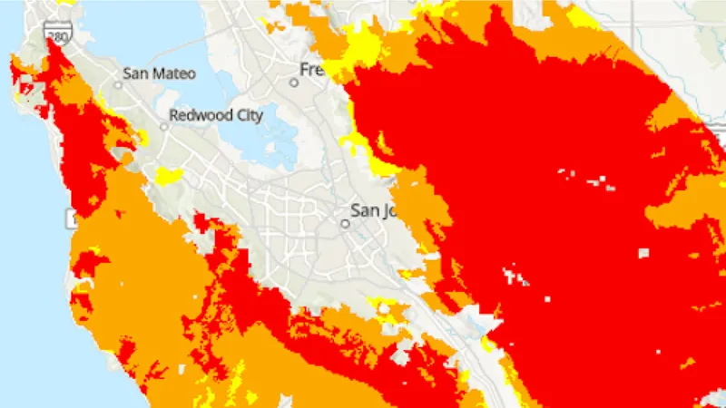
CAL FIRE Very High Fire Hazard Severity Zones (VHFHSZ) shown in red/orange
Source: CAL FIRE Fire Hazard Severity Zone data via Bay Area News Group
CAL FIRE VHFHSZ Designation
Very High and High FHSZ across the hillside neighborhoods bordering Briones Regional Park, Lafayette Ridge, and the Reliez Valley corridor. Updated per 2025 CAL FIRE maps.
Lafayette's Wildfire Record
Past fires help predict the next one. These are the biggest fires near Lafayette.
Burned through the East Bay hills west of Lafayette, destroying more than 2,800 homes. It showed how fast fire moves through oak-grass hillsides in a wind event.
Burned across the Diablo Range east of the community and prompted evacuation warnings and heavy smoke throughout central Contra Costa County.
Local Risk Factors
Oak-Grass Hillside Interface
Homes along Reliez Valley, Happy Valley, and Burton Valley back onto cured grassland and oak woodland with minimal separation from structures.
Briones and Ridgeline Open Space
Thousands of acres of continuous wildland to the north and west provide an unbroken fuel bed toward hillside neighborhoods.
Diablo Wind Events
Hot, dry offshore winds funnel through the corridor each fall, driving rapid fire spread and triggering Red Flag Warnings.
Live fire status near Lafayette
Track active incidents, Red Flag Warnings, air quality, PSPS power shutoffs, and evacuation resources for the Contra Costa County area, updated throughout the day.
Lafayette Fire Environment
Vegetation Types
Wind Patterns
Diablo wind exposure with canyon channeling from the east; multiple Red Flag Warning events per season
Topography
Valley floor near 300 feet rising into oak-covered ridgelines above 1,000 feet on the town edges.
Protecting Your Lafayette Home & Family
The steps every Lafayette homeowner should take before wildfire season.
Evacuation Planning
Know routes to Highway 24 and Pleasant Hill Road. Hillside neighborhoods off Reliez Valley have limited egress. Register for CoCo Alert.
Defensible Space
Hillside properties require 100 feet of defensible space. The Diablo Firesafe Council offers chipping and cost-share programs for Contra Costa residents.
Your Local Fire Safe Council
Diablo Firesafe Council
Lafayette Wildfire Preparedness Resources
Keeping Lafayette Homes Ready for Fire Season
- Ember-resistant vents and enclosed eaves keep embers out of the attic
- A clear 5-foot zone around the house, with nothing that burns against the walls
- Noncombustible fencing and gates where they meet the house
- Photos and records of every upgrade for your insurer
Nearby Communities We Serve
FireRoofs also installs wildfire defense systems in neighboring communities with similar WUI risk profiles.
If You Lose the Home
Lafayette, Fire Loss, and What Comes After
Lafayette's oak-covered ridgelines and open space borders give the town much of its character, and they also put it in the same wind-driven fire country that produced the 1991 East Bay Hills firestorm a few ridgelines to the west. That disaster destroyed thousands of homes and exposed how poorly most policies were written.
$1.5 billion
Insurance Gaps Surfaced Immediately
The 1991 Oakland hills firestorm destroyed more than 3,300 single-family homes and caused losses in excess of $1.5 billion. Homeowners discovered their insurance safety net was riddled with holes, a lesson that applies equally to Lafayette neighborhoods backing onto the same ridgeline terrain.[1]
$247/sq ft
Replacement Cost Estimates Lag Reality
United Policyholders surveyed households impacted by the 2025 Los Angeles wildfires during the first year and determined that 69 percent of those respondents held coverage that fell short of their needs, leaving them underinsured by an average of $247 per square foot. Older Lafayette homes with custom finishes and hillside foundations are among the property types most likely to carry outdated valuations.[2]
$20K to $40K
Stricter Codes Add to Rebuild Cost
Tubbs Fire owners who started rebuilding later faced stricter building codes, and homeowner Jim Scally put the added cost at $20,000 to $40,000 more per house. Lafayette homeowners rebuilding after a major fire would face the same ratcheting code requirements.[3]
“They sell it like it’s peace of mind plus a contract. But, they enforce it like it’s just a contract.”
Keeping Home Insurance in Lafayette
Homeowners in Lafayette are facing surging FAIR Plan rates and non-renewals from private carriers. California's Safer from Wildfires rule requires admitted insurers to offer discounts for named mitigation, like a Class A roof, ember-resistant vents and a cleared first 5 feet. Exterior sprinklers are not one of the named measures. FireRoofs provides the engineering documentation and evidence packet designed to help you qualify for the voluntary market.
Lafayette hillside properties bordering open space face elevated non-renewal rates.
Got a notice from your insurer? Here is what to do after a non-renewal.
Check Your Home's Wildfire Risk FreeNext Steps for Your Lafayette Property
FireRoofs does not install in Lafayette, but you can check your home's wildfire risk free. Enter your address to see your fire zone, your roof and the plants around your house.
Common Questions
What wildfire risk does Lafayette face?
Lafayette is designated a Very High Fire Hazard Severity Zone by CAL FIRE. Contra Costa County fire maps confirm extreme exposure driven by annual grassland and coast live oak woodland fuel loads and dry-season wind patterns. Homes along Reliez Valley, Happy Valley, and Burton Valley back onto cured grassland and oak woodland with minimal separation from structures.
Do exterior wildfire sprinklers qualify for an insurance discount in Lafayette?
Exterior sprinklers are not one of the named Safer from Wildfires categories, so no carrier is required to discount for them. A documented FireRoofs project produces evidence for the categories that are named, such as ember-resistant vents, enclosed eaves and noncombustible fencing near the house. Discounts vary by carrier.