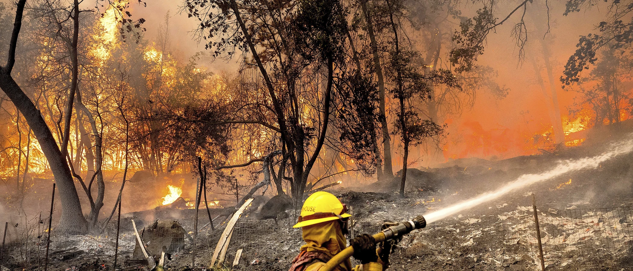
Cupertino Wildfire Defense
Cupertino's fire risk has expanded faster than almost any Bay Area city's. The Very High Fire Hazard Severity Zone grew from just 16 acres in 2011 to over 1,050 acres in the 2025 reclassification, a 65x increase. The newly designated areas include neighborhoods along Stevens Creek Canyon, the Monta Vista hillsides, and properties backing onto the Permanente Creek watershed. This expansion means hundreds of Cupertino homeowners now face new insurance requirements, AB 38 disclosure obligations, and defensible space mandates that did not apply to their properties five years ago. Several major insurers have already begun non-renewals in the affected zones.
$149 Wildfire Report for Cupertino Homeowners
See what California wildfire codes require for your Cupertino property. Covers roof, vents, defensible space, and insurance paperwork. Get your report in minutes.
acres now designated Very High FHSZ (up from 16 in 2011)
Santa Clara County
Cupertino's VHFHSZ designation grew from 16 acres to over 1,050 acres in the 2025 reclassification, affecting hundreds of homeowners' insurance and disclosure requirements.
FireRoofs Premier Home Hardening & Active Defense
FireRoofs provides premier wildfire defense and home hardening for Cupertino properties. We combine automated exterior wildfire sprinkler systems with structural hardening that addresses every ember entry point on the home. Learn more about wildfire roof sprinkler installation and how it works alongside defensible space in Cupertino.
Automated Exterior Sprinklers
Dual-detection roof and perimeter sprinklers with satellite monitoring
Ember-Resistant Vents
Retrofit vents that seal the attic from ember intrusion
Noncombustible Fencing
Eliminate the fence-to-structure flame path
Zone Zero Hardening
Clear combustible material within 5 feet of the structure
Vegetation Fire Retardant
Applied to surrounding landscape for ember resistance
Insurance Evidence Packet
Mapped to California Regulation 2644.9 for carrier submission
Cupertino's western neighborhoods extend into the Santa Cruz Mountain foothills, where residential areas border Stevens Creek Canyon and Monte Bello Open Space Preserve. Properties along Montebello Road, Regnart Canyon, and the upper hillsides face ember exposure from dense oak and chaparral vegetation. FireRoofs provides targeted hardening for Cupertino homes at the wildland-urban interface.
EmberSafe Gutter Guard Installation in Cupertino
Cupertino foothill homes near Stevens Creek and Regnart Canyon collect heavy leaf and bark debris in gutters from surrounding oak woodland. During fire events, embers from the adjacent open space can ignite gutter contents along the entire roof edge. Our stainless steel micro mesh gutter guards maintain noncombustible gutters year-round, a priority hardening upgrade recommended by the Santa Clara County FireSafe Council.
Santa Clara County FireSafe - Home HardeningVulcan Vents Ember Vent Retrofit for Cupertino Homes
Cupertino hillside homes built before WUI code updates have vents that allow ember entry into attics and crawl spaces. Canyon wind patterns in Regnart and Stevens Creek can accelerate embers directly into vent openings. Vulcan Vents with ASTM E2886 certification and intumescent sealing provide the ember and flame resistance Cupertino VHFHSZ properties require, blocking intrusion at every vent opening on the structure.
Vulcan Vents - California WUI ComplianceOpen Eave Enclosure for Cupertino Foothill Homes
Many Cupertino homes in the foothills have open eave construction with exposed rafter tails that predate WUI standards. Canyon winds channel embers directly at eave-level openings, making this a critical ignition pathway. Our eave enclosure retrofit boxes in exposed eaves with noncombustible soffit material and Chapter 7A-compliant vents, sealing the attic from ember intrusion while maintaining required ventilation.
CALBO - Chapter 7A WUI StandardsLandscape Fuelbreak for Cupertino WUI Properties
Cupertino foothill properties often feature bark mulch and ornamental plantings extending to the foundation where the lot meets wildland. Our noncombustible fuelbreak replaces these combustible materials within the Zone 0 perimeter with gravel, decomposed granite, or pavers. This treatment meets AB 3074 ember-resistant zone requirements and eliminates the ignition pathway at the building foundation.
Board of Forestry - Defensible Space ZonesNon Combustible Fencing for Cupertino Hillside Properties
Wood fencing along Cupertino foothill property lines creates fire bridges from wildland to structures. Our noncombustible fencing installation replaces combustible sections within 5 feet of the home with aluminum or steel panels meeting ASTM E136 standards. This Zone 0 measure eliminates the fence-to-structure fire pathway while maintaining the boundary definition Cupertino hillside properties require.
Ready for Wildfire - Defensible Space GuideWhy Home Hardening Matters in Cupertino
Many western Cupertino homeowners are only now learning their property falls within a fire hazard zone. Insurance carriers are already adjusting. Properties that document mitigation now will be in a stronger position as carrier risk models continue to tighten
FireRoofs helps Cupertino homeowners get ahead of the curve: automated sprinkler systems for the western hillside properties, plus home hardening upgrades that address the mitigation categories carriers are required to recognize. Everything documented in one evidence packet.

CAL FIRE Very High Fire Hazard Severity Zones (VHFHSZ) shown in red/orange
Source: CAL FIRE Fire Hazard Severity Zone data via Bay Area News Group
CAL FIRE VHFHSZ Designation
Very High FHSZ expanded from 16 acres (2011) to 1,053 acres (2025) per updated CAL FIRE maps. Cupertino officially adopted the updated map. Additional hundreds of acres in High and Moderate categories. Local Responsibility Area.
Cupertino's Wildfire Record
Understanding past fires helps predict future risk. Here are the most significant fire events near Cupertino.
The SCU Lightning Complex burned east of the region in the Diablo Range. Cupertino experienced smoke impacts but the fire did not enter the city directly.
Multiple small brush fires have affected Stevens Creek Canyon in recent decades. No major structure-destroying wildfire within city limits in recent memory.
Local Risk Factors
Massive VHFHSZ Expansion
CAL FIRE's 2025 maps expanded Cupertino's Very High FHSZ from just 16 acres to 1,053 acres, reflecting updated weather data and dramatically increased risk recognition.
Stevens Creek Canyon
Western Cupertino borders Stevens Creek Canyon, which can channel wind and fire into residential neighborhoods. Dense understory and eucalyptus pockets increase fuel loading.
Multiple Open Space Preserves
Stevens Creek County Park, Fremont Older, Picchetti Ranch, and Rancho San Antonio Open Space Preserves surround western Cupertino with thousands of acres of wildland.
Diablo Wind Vulnerability
Diablo wind events from the northeast drive fire risk in fall, with Stevens Creek Canyon acting as a wind and fire corridor toward residential areas.
Book a free on-site evaluation. We will design and install the right sprinkler and hardening system for your home.
Book Free EvaluationAll work performed by licensed and insured contractors.
Get the $149 assessment report. Find out what wildfire risk models flag on your property. Results in minutes.
Get $149 ReportCupertino Fire Environment
Vegetation Types
Wind Patterns
Diablo wind events from the northeast; Stevens Creek Canyon wind channeling; Red Flag Warnings multiple times per year
Topography
Valley floor transitions to steep canyon and foothill terrain in western Cupertino. Stevens Creek Canyon creates significant topographic fire risk. Monta Vista neighborhoods sit at the wildland transition.
Fire District
Santa Clara County Fire Department
Insurance Impact
Cupertino hillside home values are high, with many foothill properties exceeding the $3M FAIR Plan cap. Mid-range city properties may be below the cap. The dramatic VHFHSZ expansion in 2025 has increased insurance scrutiny across western Cupertino.
Protecting Your Cupertino Home & Family
Living in a fire-prone area means being proactive. Here are the steps every Cupertino homeowner should take to protect their property and prepare for wildfire season.
Evacuation Planning
Register for AlertSCC emergency notifications. Know routes to Stevens Creek Boulevard, I-280, Highway 85, and Foothill Expressway. Western hillside neighborhoods have limited egress options toward Stevens Creek Canyon.
Defensible Space
Maintain 100 feet of defensible space per PRC 4291. SCCFD conducts annual inspections in VHFHSZ areas with expanded enforcement following the 2025 map update. Take advantage of free SCCFD WUI Preparedness Inspections.


Your Local Fire Safe Council
Santa Clara County Fire Safe Council
The Santa Clara County Fire Safe Council offers free resources, community chipping programs, home assessments, and education to help Cupertino residents reduce wildfire risk and prepare for fire season.
Visit Santa Clara County Fire Safe CouncilCupertino Wildfire Preparedness Resources
Santa Clara County Fire Safe Council
Free chipper programs, home hardening guides, and community wildfire preparedness resources.
SC County Fire Safe CouncilCupertino Emergency Management
City of Cupertino emergency management including FHSZ maps and preparedness information.
City of CupertinoCAL FIRE Defensible Space Guide
Official California guide to creating defensible space zones around your property.
CAL FIREProtect Your Cupertino Home with FireRoofs
Defensible space and evacuation planning are essential, but they have limits. When embers are raining down and flames are approaching, your home needs both an automated active defense system and structural hardening that eliminates every ember entry point.
FireRoofs combines automated exterior sprinkler systems with structural home hardening for Cupertino properties. Our Detect → Alert → Defend system uses intelligent wildfire detection cameras, satellite monitoring, and high-pressure water to saturate your property. Our hardening scope seals every vulnerability embers exploit.
- Automated exterior sprinklers: roof and perimeter coverage with dual detection
- Ember-resistant vent retrofits to seal the attic from intrusion
- Noncombustible fencing to eliminate the fence-to-structure flame path
- Zone Zero landscape hardening within 5 feet of the structure
- Vegetation fire retardant application for surrounding landscape
- Class A firefighting foam add-on: 100% biodegradable, non-toxic, rinses off through sprinklers
- Insurance evidence packet documenting all upgrades, mapped to California Regulation 2644.9


Local Wildfire Resources for Cupertino Homeowners
Rules and requirements can change. Verify current requirements with your city or fire district before taking action.

Tree Removal and Defensible Space Rules
Cupertino follows Santa Clara County tree preservation with local amendments. Protected tree permits required. Fire hazard exemptions available for defensible space compliance in VHFHSZ areas.
Fire Hazard Severity Zone: Very High zones expanded dramatically from 16 acres (2011) to 1,053 acres (2025). Additional hundreds of acres in High and Moderate categories. Cupertino officially adopted the updated CAL FIRE map. Local Responsibility Area.

Free Programs for Cupertino Homeowners
- SCCFD chipper programs via Santa Clara County Fire Safe Council
- Free SCCFD WUI Preparedness Inspections
- Ready, Set, Go! program
Your Fire District
Santa Clara County Fire Department (SCCFD)
Community Designations
- Firewise USA communities in hillside neighborhoods
- Part of Santa Clara County CWPP
Community designations like Firewise USA and Fire Risk Reduction Community may qualify homeowners for insurance benefits under California's Safer from Wildfires regulation.

Statewide Zone 0 Compliance Timeline
Board of Forestry rulemaking targeted for completion by December 31, 2025. New construction: compliance begins once rules are adopted (projected 2026). Existing structures: 3-year phase-in (compliance expected by approximately 2028-2029).
State Defensible Space (PRC 4291)
Zone 0: 0-5 feet, ember-resistant/noncombustible. Zone 1: 5-30 feet, lean, clean, and green. Zone 2: 30-100 feet, reduced fuel loading. Annual compliance inspections by local fire districts during fire season.
California Building Code
Effective 2026, California Wildland-Urban Interface Code (CWUIC) Part 7 replaces CBC Chapter 7A. Applies to new construction in designated fire hazard zones.
How FireRoofs Fits In
Understanding your local requirements is the first step. A FireRoofs automated defense system works alongside your defensible space, home hardening, and community efforts to give your home the strongest possible protection. During your free property evaluation, our team reviews your property in the context of Cupertino's specific requirements and helps you understand how active defense fits into your overall wildfire strategy.
Nearby Communities We Serve
FireRoofs also installs wildfire defense systems in neighboring communities with similar WUI risk profiles.
2026 Insurance Alert for Cupertino Homeowners
Homeowners in Cupertino are facing surging FAIR Plan rates and non-renewals from private carriers. California's Safer from Wildfires framework now requires participating insurers to offer discounts for documented mitigation systems. FireRoofs provides the engineering documentation and evidence packet designed to help you qualify for the voluntary market.
California's SB 429 (effective January 1, 2026) establishes the nation's first public wildfire catastrophe model, giving homeowners new tools to understand insurance risk scores. Ask HydroIQ what this means for Cupertino homeowners.
Request a Free Property EvaluationAsk HydroIQ About Cupertino - Free AI Wildfire Assistant
Get instant answers about Cupertino's wildfire risk level, defensible space requirements, fire history, FAIR Plan insurance options, and how exterior sprinkler systems can protect your home. HydroIQ covers communities across all nine Bay Area counties.
Protect Your Cupertino Property Today
Every Cupertino property is different. Get a free evaluation of your home's wildfire exposure and a custom defense plan.
Common Questions
What wildfire risk does Cupertino face?
Cupertino is designated a Very High Fire Hazard Severity Zone by CAL FIRE. Santa Clara County fire maps confirm extreme exposure driven by oak woodland and chaparral fuel loads and dry-season wind patterns. CAL FIRE's 2025 maps expanded Cupertino's Very High FHSZ from just 16 acres to 1,053 acres, reflecting updated weather data and dramatically increased risk recognition.
How does FireRoofs protect Cupertino homes from wildfire?
FireRoofs provides both active defense and passive home hardening for Cupertino properties. Active defense includes automated exterior sprinkler systems with dual detection, satellite monitoring, and intelligent fire detection cameras. Passive hardening covers ember-resistant vent retrofits, noncombustible fencing, Zone Zero landscape hardening, exterior cladding upgrades, and vegetation fire retardant. Every upgrade is documented in one evidence packet mapped to California Regulation 2644.9 for insurance recognition.
What does home hardening include for a Cupertino property?
Home hardening for Cupertino properties addresses every ember entry point on the structure. FireRoofs performs ember-resistant vent installation, noncombustible fencing replacement, eave and soffit sealing, Zone Zero landscape clearance within 5 feet of the structure, vegetation fire retardant application, and exterior cladding upgrades where needed. Scope is determined during a free property evaluation and accounts for site-specific conditions including lot size and exposure. All work is documented for insurance submission.
Where can I get instant answers about Cupertino's wildfire risk?
HydroIQ is FireRoofs' free wildfire assistant that provides instant, city-specific answers about Cupertino's fire hazard zone classification, defensible space requirements, local fire history, FAIR Plan insurance options, and wildfire defense systems. No sign-up required. Visit fireroofs.com/hydroiq to learn more or ask a question directly.
What is California home hardening?
California home hardening is the process of retrofitting a structure to resist wildfire ember intrusion and radiant heat exposure. It includes replacing combustible building materials, sealing openings such as attic vents and eaves, installing noncombustible fencing, clearing the Zone Zero perimeter within 5 feet of the structure, and applying fire-resistant treatments. Home hardening is one of the 12 mitigation categories under California Regulation 2644.9 (Safer from Wildfires) that participating insurers must recognize when setting premiums.
How do I get off the California FAIR Plan?
To transition from the California FAIR Plan back to the voluntary insurance market, homeowners need to demonstrate documented wildfire risk reduction. This includes property-level mitigation such as home hardening, automated exterior sprinkler systems, and defensible space maintenance. Under California Regulation 2644.9, admitted insurers are required to offer premium discounts for documented mitigation across 12 categories. FireRoofs provides the upgrades and the evidence packet that documents each improvement for your insurer or broker.
What are the 12 Safer from Wildfires mitigation categories?
California Regulation 2644.9 defines 12 mitigation categories that insurers must recognize: (1) Class A fire-rated roof, (2) Enclosed eaves, (3) Ember-resistant vents, (4) Exterior wall cladding, (5) Dual-pane or tempered windows, (6) Noncombustible fencing within 5 feet, (7) Defensible space Zone 0-2 maintained, (8) Community-level mitigation (Fire Risk Reduction Community), (9) Active fire defense system such as exterior sprinklers, (10) Fire-resistant landscaping, (11) Access and water supply, (12) Structure-specific risk reduction. FireRoofs addresses categories 1 through 10 directly.
Do exterior roof sprinklers qualify for insurance discounts in California?
Yes. Automated exterior sprinkler systems are recognized under Category 9 (Active Fire Defense System) of California Regulation 2644.9. When documented in an evidence packet and submitted to your insurer, they count toward the mitigation credits that admitted carriers are required to apply. FireRoofs installs dual-detection exterior sprinkler systems and provides the documentation package for insurance recognition. SB 429 (effective January 1, 2026) further supports this by establishing a public wildfire catastrophe model that factors documented improvements into risk scoring.
How much has Cupertino's fire hazard zone expanded?
Cupertino's Very High FHSZ expanded from just 16 acres in 2011 to 1,053 acres in 2025 per the updated CAL FIRE maps. This dramatic increase reflects improved weather data and climate risk modeling. The city officially adopted the updated maps.
Are there free wildfire programs for Cupertino homeowners?
Yes. SCCFD offers free WUI Preparedness Inspections and participates in the Ready, Set, Go! program. The Santa Clara County Fire Safe Council provides chipper programs for VHFHSZ residents at sccfiresafe.org.
What areas of Cupertino are most at risk?
Western Cupertino near Stevens Creek Canyon and the Santa Cruz Mountains foothills faces the highest risk. The Monta Vista neighborhood and areas adjacent to Stevens Creek County Park, Fremont Older, and Picchetti Ranch preserves have the most WUI exposure.