Woodside Wildfire Defense
Woodside is not a typical suburban fire risk. It is rural estate country inside one of the most fire-prone landscapes on the Peninsula. Properties on Skyline Boulevard, Kings Mountain Road, and Old La Honda Road sit in dense second-growth redwood and eucalyptus forest with no hydrants, no curbs, and in some cases, no cell service. The Woodside Fire Protection District covers 30 square miles of this terrain with a single station. When the 2020 CZU fire burned to within 8 miles of town, mutual aid from five neighboring departments was required just to staff evacuation checkpoints.
$149 Wildfire Report for Woodside Homeowners
See what California wildfire codes require for your Woodside property. Covers roof, vents, defensible space, and insurance paperwork. Get your report in minutes.
CAL FIRE Risk Designation
San Mateo County
Woodside's rural estate properties sit within dense forest along the Santa Cruz Mountains with limited fire infrastructure.
FireRoofs Premier Home Hardening & Active Defense
FireRoofs provides premier wildfire defense and home hardening for Woodside properties. We combine automated exterior sprinkler systems with structural hardening that addresses every ember entry point on the home.
Automated Exterior Sprinklers
Dual-detection roof and perimeter sprinklers with satellite monitoring
Ember-Resistant Vents
Retrofit vents that seal the attic from ember intrusion
Noncombustible Fencing
Eliminate the fence-to-structure flame path
Zone Zero Hardening
Clear combustible material within 5 feet of the structure
Vegetation Fire Retardant
Applied to surrounding landscape for ember resistance
Insurance Evidence Packet
Mapped to California Regulation 2644.9 for carrier submission
Woodside properties spread across densely wooded hillsides in San Mateo County, where mature redwood, oak, and eucalyptus groves border large-lot estates. Limited road access and heavy tree canopy make Woodside uniquely vulnerable to both ember attack and radiant heat exposure. Each FireRoofs hardening scope addresses the specific ignition pathways present on Woodside lots.
Stainless Steel Gutter Guard Installation in Woodside
Woodside estates under heavy redwood and eucalyptus canopy accumulate bark strips, needles, and leaf debris in gutters at rates far exceeding typical suburban homes. Eucalyptus bark is extremely flammable and a primary ember fuel source. Our micro mesh gutter guards are fabricated from surgical-grade stainless steel that blocks all debris while resisting corrosion from coastal moisture and tannin-heavy runoff.
Fire Safe San Mateo - Home Hardening GuideEmber & Flame Resistant Vent Retrofit for Woodside Estates
Large Woodside homes often have multiple vent types spread across expansive roof lines, including ridge vents, gable vents, and foundation crawl space vents. Each opening is a potential ember entry point. Vulcan Vents provide ASTM E2886-certified protection across all vent configurations, with intumescent technology that activates at wildfire temperatures to seal openings that standard mesh cannot protect.
Vulcan Vents - Codes & ComplianceLandscape-to-Structure Fuelbreak for Woodside Properties
Woodside lots frequently feature ornamental gardens, bark mulch, and dense plantings extending directly to the foundation. Under AB 3074 Zone 0 requirements, the first 5 feet from the structure must be an ember-resistant zone free of combustible materials. Our fuelbreak replaces organic mulch and combustible plantings with gravel, stone, or concrete hardscaping that prevents ember ignition at the foundation line.
Board of Forestry - Defensible Space ZonesUnder Deck Enclosure for Woodside Hillside Estates
Elevated decks on Woodside hillside properties create sheltered spaces underneath where windblown leaves and debris collect. During a wildfire, embers igniting this accumulated fuel can produce sustained flames against floor joists and siding. Our enclosure system screens the under-deck perimeter with corrosion-resistant metal mesh (1/8-inch maximum openings) while maintaining airflow to prevent moisture damage to structural members.
Fire Safe Marin - Deck & Porch ProtectionNon Combustible Fencing Installation in Woodside
Wood rail fencing along property lines and paddock enclosures is common on Woodside estates, creating direct fire pathways from wildland to structures. California Zone 0 regulations require any fencing within 5 feet of the structure to be noncombustible. Our installation uses aluminum, steel, or masonry fencing that meets ASTM E136 noncombustibility standards while preserving the rural character Woodside homeowners expect.
Ready for Wildfire - Defensible Space GuideWhy Home Hardening Matters in Woodside
Woodside’s nearly universal WUI exposure means there is no “safe” side of town. Homes built under older codes often have wood fencing connecting to the main structure, open eaves, standard vents, and combustible landscaping within the Zone Zero perimeter. FireRoofs approaches Woodside properties as multi-structure projects. Sprinkler systems cover the main home and outbuildings
Hardening addresses every structure: fencing, vents, eaves, cladding, Zone Zero clearance. Defensible space work extends across the full lot. One scope of work, one evidence packet that covers the entire property.

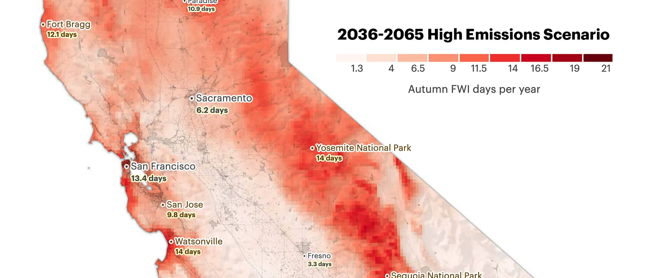
CAL FIRE Very High Fire Hazard Severity Zones (VHFHSZ) shown in red/orange
Source: CAL FIRE Fire Hazard Severity Zone data via Bay Area News Group
CAL FIRE VHFHSZ Designation
The majority of Woodside falls within CAL FIRE's Very High Fire Hazard Severity Zone, one of the most extensively designated communities in the Bay Area owing to dense forests and steep terrain.
Woodside's Wildfire Record
Understanding past fires helps predict future risk. Here are the most significant fire events near Woodside.
Though primarily burning further south, smoke and ember showers reached Woodside, demonstrating vulnerability.
A significant wildfire swept through the hills destroying multiple homes and burning hundreds of acres of watershed.
Burned 399 acres in Santa Cruz County, a reminder of fire risk throughout the mountain corridor.
Local Risk Factors
Dense Forest Canopy
Redwood, eucalyptus, and oak forests provide continuous fuel ladders from ground to crown, enabling explosive fire growth.
Large Rural Properties
Estate-sized lots mean homes are spread across heavily vegetated terrain with limited mutual aid capabilities.
Narrow Winding Roads
Single-lane roads through dense forest create evacuation bottlenecks and limit fire engine access.
Eucalyptus Groves
Highly flammable eucalyptus trees shed bark that carries embers miles ahead of the fire front.
Book a free on-site evaluation. We will design and install the right sprinkler and hardening system for your home.
Book Free EvaluationGet the $149 assessment report. Find out what wildfire risk models flag on your property. Results in minutes.
Get $149 ReportWoodside Fire Environment
Vegetation Types
Wind Patterns
Offshore winds; coastal fog influence reduces but doesn't eliminate risk
Topography
Elevation 200-2,200 ft. Heavily forested ridgelines with steep east-facing slopes.
Fire District
Woodside Fire Protection District
Insurance Impact
Woodside has seen some of the highest non-renewal rates in San Mateo County, with significant premium increases for properties retaining coverage.
Protecting Your Woodside Home & Family
Living in a fire-prone area means being proactive. Here are the steps every Woodside homeowner should take to protect their property and prepare for wildfire season.
Evacuation Planning
Woodside has narrow, winding roads through heavily wooded terrain. The Woodside Fire Protection District works with Zonehaven for evacuation zone management. Register for SMC Alert and know your zone number before fire season.
Defensible Space
Woodside adopted home hardening ordinances requiring Class A roofing, ember-resistant vents, and non-combustible fencing within 5 feet of structures. Take advantage of the Neighborhood Chipper Program through Fire Safe San Mateo for free vegetation disposal.


Your Local Fire Safe Council
Fire Safe San Mateo County
The Fire Safe San Mateo County offers free resources, community chipping programs, home assessments, and education to help Woodside residents reduce wildfire risk and prepare for fire season.
Visit Fire Safe San Mateo CountyWoodside Wildfire Preparedness Resources
Fire Safe San Mateo County
Neighborhood Chipper Program, home hardening education, and defensible space resources for Woodside.
Fire Safe San MateoWoodside Fire Protection District
Personalized wildfire readiness info, home assessments, and Firewise community programs.
Woodside FPDSMC Alert Emergency Notifications
San Mateo County reverse 911 system for evacuation orders and emergency alerts.
San Mateo CountyProtect Your Woodside Home with FireRoofs
Defensible space and evacuation planning are essential, but they have limits. When embers are raining down and flames are approaching, your home needs both an automated active defense system and structural hardening that eliminates every ember entry point.
FireRoofs combines automated exterior sprinkler systems with structural home hardening for Woodside properties. Our Detect → Alert → Defend system uses intelligent wildfire detection cameras, satellite monitoring, and high-pressure water to saturate your property. Our hardening scope seals every vulnerability embers exploit.
- Automated exterior sprinklers: roof and perimeter coverage with dual detection
- Ember-resistant vent retrofits to seal the attic from intrusion
- Noncombustible fencing to eliminate the fence-to-structure flame path
- Zone Zero landscape hardening within 5 feet of the structure
- Vegetation fire retardant application for surrounding landscape
- Class A firefighting foam add-on: 100% biodegradable, non-toxic, rinses off through sprinklers
- Insurance evidence packet documenting all upgrades, mapped to California Regulation 2644.9


Local Wildfire Resources for Woodside Homeowners
Rules and requirements can change. Verify current requirements with your city or fire district before taking action.

Tree Removal and Defensible Space Rules
Permits required for trees over 12 inches diameter (at 4.5 feet height). Exemptions for dead/dying trees and defensible space within 30 feet per PRC 4291. Heritage protections with VHFHSZ exceptions. WFPD Ordinance 24-01 (effective May 30, 2024) mandates fuel mitigation with annual inspections.
Fire Hazard Severity Zone: Very High (approximately 85-95%). Local Responsibility Area.

Free Programs for Woodside Homeowners
- WFPD free chipper program (May through November for VHFHSZ residents)
- Free defensible space consultations and inspections
Financial Assistance Available
Town of Woodside Defensible Space and Home Hardening Matching Fund Program: 50% reimbursement for approved projects, up to $3,000 maximum.
Your Fire District
Woodside Fire Protection District (WFPD)
Community Designations
- Multiple Firewise USA neighborhoods
Community designations like Firewise USA and Fire Risk Reduction Community may qualify homeowners for insurance benefits under California's Safer from Wildfires regulation.

Statewide Zone 0 Compliance Timeline
Board of Forestry rulemaking targeted for completion by December 31, 2025. New construction: compliance begins once rules are adopted (projected 2026). Existing structures: 3-year phase-in (compliance expected by approximately 2028-2029).
State Defensible Space (PRC 4291)
Zone 0: 0-5 feet, ember-resistant/noncombustible. Zone 1: 5-30 feet, lean, clean, and green. Zone 2: 30-100 feet, reduced fuel loading. Annual compliance inspections by local fire districts during fire season.
California Building Code
Effective 2026, California Wildland-Urban Interface Code (CWUIC) Part 7 replaces CBC Chapter 7A. Applies to new construction in designated fire hazard zones.
How FireRoofs Fits In
Understanding your local requirements is the first step. A FireRoofs automated defense system works alongside your defensible space, home hardening, and community efforts to give your home the strongest possible protection. During your free property evaluation, our team reviews your property in the context of Woodside's specific requirements and helps you understand how active defense fits into your overall wildfire strategy.
We Also Serve Nearby Communities
FireRoofs provides wildfire defense systems throughout the San Mateo County region. Here are neighboring communities we protect:
San Carlos
San Carlos shares the same San Mateo County foothill corridor as Woodside. Neighborhoods in Beverly Terrace and Alder Manor are designated high fire hazard by CAL FIRE, with many homes at elevated risk. The city invests in vegetation reduction in WUI areas and partners with the Redwood City Fire Department for wildfire response and code enforcement.
Belmont
Belmont's western hillside neighborhoods face significant wildfire risk where residential development meets open space. Since 2020, the city has made wildfire mitigation a strategic priority, partnering with CAL FIRE inmate crews to remove 100-200 acres of hazardous fuels annually. Belmont secured a FEMA Pre-Disaster Mitigation Grant in 2024 for vegetation management in the WUI.
Live in one of these communities? FireRoofs offers free home evaluations throughout San Mateo County and the greater Bay Area. Book your free evaluation or call 831-705-0888.
Nearby Communities We Serve
FireRoofs also installs wildfire defense systems in neighboring communities with similar WUI risk profiles.
2026 Insurance Alert for Woodside Homeowners
Homeowners in Woodside are facing surging FAIR Plan rates and non-renewals from private carriers. California's Safer from Wildfires framework now requires participating insurers to offer discounts for documented mitigation systems. FireRoofs provides the engineering documentation and evidence packet designed to help you qualify for the voluntary market.
California's SB 429 (effective January 1, 2026) establishes the nation's first public wildfire catastrophe model, giving homeowners new tools to understand insurance risk scores. Ask HydroIQ what this means for Woodside homeowners.
Request a Free Property EvaluationAsk HydroIQ About Woodside - Free AI Wildfire Assistant
Get instant answers about Woodside's wildfire risk level, defensible space requirements, fire history, FAIR Plan insurance options, and how exterior sprinkler systems can protect your home. HydroIQ covers communities across all nine Bay Area counties.
Protect Your Woodside Property Today
Every Woodside property is different. Get a free evaluation of your home's wildfire exposure and a custom defense plan.
Common Questions
What wildfire risk does Woodside face?
Woodside is designated a Very High Fire Hazard Severity Zone by CAL FIRE. San Mateo County fire maps confirm extreme exposure driven by redwood forest and coast live oak fuel loads and seasonal offshore winds. Redwood, eucalyptus, and oak forests provide continuous fuel ladders from ground to crown, enabling explosive fire growth.
How does FireRoofs protect Woodside homes from wildfire?
FireRoofs provides both active defense and passive home hardening for Woodside properties. Active defense includes automated exterior sprinkler systems with dual detection, satellite monitoring, and intelligent fire detection cameras. Passive hardening covers ember-resistant vent retrofits, noncombustible fencing, Zone Zero landscape hardening, exterior cladding upgrades, and vegetation fire retardant. Every upgrade is documented in one evidence packet mapped to California Regulation 2644.9 for insurance recognition.
What does home hardening include for a Woodside property?
Home hardening for Woodside properties addresses every ember entry point on the structure. FireRoofs performs ember-resistant vent installation, noncombustible fencing replacement, eave and soffit sealing, Zone Zero landscape clearance within 5 feet of the structure, vegetation fire retardant application, and exterior cladding upgrades where needed. Scope is determined during a free property evaluation and accounts for local terrain and elevation changes. All work is documented for insurance submission.
Where can I get instant answers about Woodside's wildfire risk?
HydroIQ is FireRoofs' free wildfire assistant that provides instant, city-specific answers about Woodside's fire hazard zone classification, defensible space requirements, local fire history, FAIR Plan insurance options, and wildfire defense systems. No sign-up required. Visit fireroofs.com/hydroiq to learn more or ask a question directly.
What is California home hardening?
California home hardening is the process of retrofitting a structure to resist wildfire ember intrusion and radiant heat exposure. It includes replacing combustible building materials, sealing openings such as attic vents and eaves, installing noncombustible fencing, clearing the Zone Zero perimeter within 5 feet of the structure, and applying fire-resistant treatments. Home hardening is one of the 12 mitigation categories under California Regulation 2644.9 (Safer from Wildfires) that participating insurers must recognize when setting premiums.
How do I get off the California FAIR Plan?
To transition from the California FAIR Plan back to the voluntary insurance market, homeowners need to demonstrate documented wildfire risk reduction. This includes property-level mitigation such as home hardening, automated exterior sprinkler systems, and defensible space maintenance. Under California Regulation 2644.9, admitted insurers are required to offer premium discounts for documented mitigation across 12 categories. FireRoofs provides the upgrades and the evidence packet that documents each improvement for your insurer or broker.
What are the 12 Safer from Wildfires mitigation categories?
California Regulation 2644.9 defines 12 mitigation categories that insurers must recognize: (1) Class A fire-rated roof, (2) Enclosed eaves, (3) Ember-resistant vents, (4) Exterior wall cladding, (5) Dual-pane or tempered windows, (6) Noncombustible fencing within 5 feet, (7) Defensible space Zone 0-2 maintained, (8) Community-level mitigation (Fire Risk Reduction Community), (9) Active fire defense system such as exterior sprinklers, (10) Fire-resistant landscaping, (11) Access and water supply, (12) Structure-specific risk reduction. FireRoofs addresses categories 1 through 10 directly.
Do exterior roof sprinklers qualify for insurance discounts in California?
Yes. Automated exterior sprinkler systems are recognized under Category 9 (Active Fire Defense System) of California Regulation 2644.9. When documented in an evidence packet and submitted to your insurer, they count toward the mitigation credits that admitted carriers are required to apply. FireRoofs installs dual-detection exterior sprinkler systems and provides the documentation package for insurance recognition. SB 429 (effective January 1, 2026) further supports this by establishing a public wildfire catastrophe model that factors documented improvements into risk scoring.
Does Woodside offer financial help for defensible space?
Yes. The Town of Woodside Defensible Space and Home Hardening Matching Fund Program reimburses 50% of approved project costs, up to $3,000. The Woodside Fire Protection District also offers a free chipper program from May through November for VHFHSZ residents.
What are Woodside defensible space requirements?
The Woodside Fire Protection District's Ordinance 24-01 (effective May 2024) requires property owners to create defensible space within 100 feet of structures, following state PRC 4291 zones. Annual inspections are conducted in VHFHSZ areas.
What tree removal rules apply in Woodside?
Permits are required for trees over 12 inches diameter (at 4.5 feet height). Exemptions exist for dead or dying trees and defensible space removals within 30 feet of structures. Heritage tree protections include VHFHSZ exceptions.