Saratoga Wildfire Defense
In 2020, the CZU Lightning Complex burned 86,500 acres just miles from Saratoga's hillside neighborhoods along Congress Springs Road and Pierce Road. Residents at elevations above 1,000 feet watched the fire line from their decks. The western foothills of the Santa Cruz Mountains are VHFHSZ-designated here because of steep canyon terrain that funnels fire uphill and mature oak-madrone forest that connects directly to backyards. Many homes on Bohlman Road and Mount Eden Road sit on single-lane roads where evacuation and fire truck access compete for the same narrow path.
$149 Wildfire Report for Saratoga Homeowners
See what California wildfire codes require for your Saratoga property. Covers roof, vents, defensible space, and insurance paperwork. Get your report in minutes.
Santa Clara County communities with VHFHSZ designation
Santa Clara County
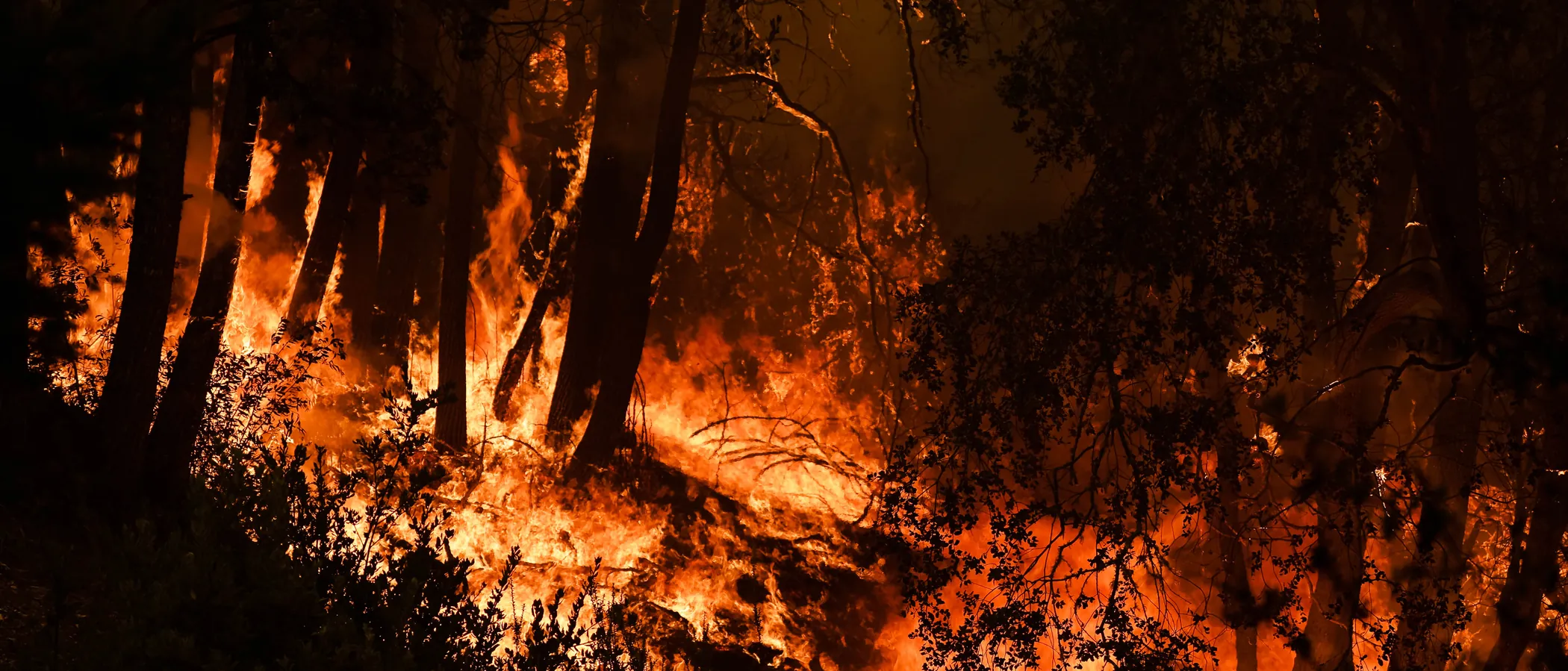
The 2020 CZU Lightning Complex fire burned 86,500 acres in the Santa Cruz Mountains, triggering evacuations for Saratoga foothill residents.
FireRoofs Premier Home Hardening & Active Defense
FireRoofs provides premier wildfire defense and home hardening for Saratoga properties. We combine automated exterior sprinkler systems with structural hardening that addresses every ember entry point on the home.
Automated Exterior Sprinklers
Dual-detection roof and perimeter sprinklers with satellite monitoring
Ember-Resistant Vents
Retrofit vents that seal the attic from ember intrusion
Noncombustible Fencing
Eliminate the fence-to-structure flame path
Zone Zero Hardening
Clear combustible material within 5 feet of the structure
Vegetation Fire Retardant
Applied to surrounding landscape for ember resistance
Insurance Evidence Packet
Mapped to California Regulation 2644.9 for carrier submission
Saratoga properties along the Santa Cruz Mountain foothills face ember showers driven by offshore winds through steep canyons. Dense oak and madrone canopy drops heavy debris loads on roofs and into gutters, while many hillside homes have exposed eaves and aging wood decks that create direct ignition pathways. FireRoofs addresses each vulnerability with targeted hardening retrofits designed for Saratoga terrain.
EmberSafe Gutter Guard Installation in Saratoga
Saratoga gutters collect heavy oak leaf and bay laurel litter year-round, creating a fuel bed that embers ignite on contact. Our stainless steel micro mesh gutter guards block debris accumulation while allowing water to drain freely. Noncombustible gutter covers are recommended by CAL FIRE and local Fire Safe Councils as a frontline home hardening measure for VHFHSZ properties.
Fire Safe Marin - Gutter Hardening GuideEmber-Resistant Vent Retrofit for Saratoga Homes
Many Saratoga hillside homes still have 1/4-inch mesh attic vents that allow embers to enter freely. Vulcan Vents feature stainless steel ember mesh and an intumescent honeycomb matrix that expands under heat to create a fire wall. They are tested to ASTM E2886 and listed by the California State Fire Marshal, meeting the Chapter 7A WUI building code requirements that apply to Saratoga VHFHSZ properties.
Vulcan Vents - California Code ComplianceLandscape-to-Structure Fuelbreak Installation in Saratoga
Where Saratoga wildland meets residential lots, combustible mulch, bark, and ornamental plantings within 5 feet of the structure create a direct ignition pathway. Our noncombustible fuelbreak replaces organic materials with gravel, pavers, or bare mineral soil to meet Zone 0 ember-resistant zone requirements established under AB 3074 and enforced by the Board of Forestry.
Board of Forestry - Zone 0 RegulationsUnder Deck Enclosure for Saratoga Hillside Homes
Hillside homes in upper Saratoga commonly have elevated decks with exposed undersides that trap windblown debris and leaves. Embers landing under an unprotected deck can ignite accumulated fuel and expose floor framing and siding to direct flame. Our under deck enclosures use noncombustible metal mesh screening or fiber-cement panels to seal the space while maintaining the ventilation needed to prevent moisture damage.
Fire Safe Marin - Deck Fire ProtectionOpen Eave Enclosure for Saratoga Properties
Open eave construction exposes rafter tails and blocking to ember intrusion, giving fire a direct path into the attic. Many original Saratoga foothill homes were built with open eaves before WUI codes existed. Our enclosure retrofit boxes in exposed eaves with noncombustible soffit material and WUI-compliant vents, meeting California Building Code Chapter 7A requirements for exterior wildfire exposure.
CALBO - Chapter 7A WUI Code ChangesWhy Home Hardening Matters in Saratoga
Saratoga hillside properties are among the most exposed in the Bay Area. Many homes were built before modern fire codes, with wood fencing, combustible eaves, standard vents, and mature vegetation growing within feet of the structure. These are the exact conditions that allow ember ignition during a wildfire. FireRoofs addresses this with a combined approach: automated exterior sprinklers that saturate the property before fire arrives, plus physical home hardening that removes the ignition pathways embers exploit. Noncombustible fencing to eliminate the fence-to-structure flame path
Ember-resistant vents to seal the attic. Zone Zero landscape hardening to clear combustible material from within 5 feet of the home. Each upgrade is documented and mapped to California’s Regulation 2644.9 for insurance recognition. Saratoga is a designated Fire Risk Reduction Community, which qualifies under one of the 12 mitigation categories. Homeowners who combine that community designation with property-level hardening and active defense can present the strongest possible case to their insurer.

CAL FIRE Very High Fire Hazard Severity Zones (VHFHSZ) shown in red/orange
Source: CAL FIRE Fire Hazard Severity Zone data via Bay Area News Group
CAL FIRE VHFHSZ Designation
One of 6 communities in Santa Clara County with Very High Fire Hazard Severity Zone designations by CAL FIRE. VHFHSZ areas are concentrated in the western foothills and areas bordering Sanborn County Park and the Monte Bello Open Space Preserve.
Saratoga's Wildfire Record
Understanding past fires helps predict future risk. Here are the most significant fire events near Saratoga.
Burned 86,509 acres in Santa Cruz Mountains, threatening Saratoga foothill properties and triggering evacuations.
Burned 4,270 acres and destroyed 132 structures near Summit Road, prompting evacuation warnings for upper Saratoga residents.
Over 13,000 acres burned in the hills above Lexington Reservoir, destroying 42 homes and directly threatening Saratoga neighborhoods.
Local Risk Factors
Steep Canyon Terrain
The western foothills feature steep canyons that channel fire and create dangerous updrafts, accelerating fire spread toward residential areas.
Dense Vegetation Interface
Mature oak, bay laurel, and madrone forests extend directly into neighborhoods with minimal defensible space between wildlands and homes.
Limited Evacuation Routes
Many hillside neighborhoods have single-access roads that can become bottlenecked during evacuations, increasing risk for residents.
Offshore Wind Exposure
Hot, dry offshore winds funnel through mountain passes and can push fire rapidly into developed areas.
Book a free on-site evaluation. We will design and install the right sprinkler and hardening system for your home.
Book Free EvaluationGet the $149 assessment report. Find out what wildfire risk models flag on your property. Results in minutes.
Get $149 ReportSaratoga Fire Environment
Vegetation Types
Wind Patterns
Seasonal offshore winds (NE) in fall; sea breeze (W) in summer
Topography
Elevation ranges from 400 ft to 2,600 ft. Steep west-facing slopes create fire chimneys.
Fire District
Saratoga Fire District, Station 1
Insurance Impact
Multiple major insurers have non-renewed policies in upper Saratoga since 2019. FAIR Plan enrollments have increased significantly in Santa Clara County's WUI zones.
Protecting Your Saratoga Home & Family
Living in a fire-prone area means being proactive. Here are the steps every Saratoga homeowner should take to protect their property and prepare for wildfire season.
Evacuation Planning
Many Saratoga hillside neighborhoods have single-access roads. Know your evacuation zone via Zonehaven and register for AlertSCC emergency notifications. Keep your vehicle fueled and a go-bag packed during fire season.
Defensible Space
Saratoga WUI residents can receive free Home Ignition Zone inspections and up to $10,000 in structure hardening rebates through the Santa Clara County FireSafe Council. Clear vegetation within 5 feet of your home and maintain lean landscaping out to 100 feet.


Your Local Fire Safe Council
Santa Clara County FireSafe Council
The Santa Clara County FireSafe Council offers free resources, community chipping programs, home assessments, and education to help Saratoga residents reduce wildfire risk and prepare for fire season.
Visit Santa Clara County FireSafe CouncilSaratoga Wildfire Preparedness Resources
Santa Clara County FireSafe Council
Free chipping, HIZ inspections, defensible space assistance, and structure hardening rebates for Saratoga WUI residents.
SCC FireSafe CouncilAlertSCC Emergency Notifications
Register for Santa Clara County emergency alerts including evacuation orders and wildfire warnings.
Santa Clara County OESCAL FIRE Defensible Space Guide
Official California guide to creating defensible space zones around your property.
CAL FIREProtect Your Saratoga Home with FireRoofs
Defensible space and evacuation planning are essential, but they have limits. When embers are raining down and flames are approaching, your home needs both an automated active defense system and structural hardening that eliminates every ember entry point.
FireRoofs combines automated exterior sprinkler systems with structural home hardening for Saratoga properties. Our Detect → Alert → Defend system uses intelligent wildfire detection cameras, satellite monitoring, and high-pressure water to saturate your property. Our hardening scope seals every vulnerability embers exploit.
- Automated exterior sprinklers: roof and perimeter coverage with dual detection
- Ember-resistant vent retrofits to seal the attic from intrusion
- Noncombustible fencing to eliminate the fence-to-structure flame path
- Zone Zero landscape hardening within 5 feet of the structure
- Vegetation fire retardant application for surrounding landscape
- Class A firefighting foam add-on: 100% biodegradable, non-toxic, rinses off through sprinklers
- Insurance evidence packet documenting all upgrades, mapped to California Regulation 2644.9


Local Wildfire Resources for Saratoga Homeowners
Rules and requirements can change. Verify current requirements with your city or fire district before taking action.

Tree Removal and Defensible Space Rules
Saratoga updated its tree regulations effective March 6, 2026. Homeowners citywide may remove trees within 5 feet of their home for wildfire risk reduction, provided a noncombustible zone is maintained within 5 feet. A city tree removal permit is still required but the process has no public notification or appeal. In the Wildland-Urban Interface (WUI), trees within 100 feet of a structure that create increased wildfire risk may be removed with a permit. Permits are free for dead or fallen trees, Monterey pine, and blue gum eucalyptus in the WUI (photos required with permit). Reduced tree replacement requirements in WUI for development projects.
Fire Hazard Severity Zone: Very High (approximately 80-95% of city per 2025 CAL FIRE maps). Local Responsibility Area.

Free Programs for Saratoga Homeowners
- Santa Clara County Fire Safe Council chipper days (free for VHFHSZ residents, apply at sccfiresafe.org)
- Free Home Ignition Zone (HIZ) inspections through the Fire Safe Council
Your Fire District
Santa Clara County Central Fire Protection District
Community Designations
- Fire Risk Reduction Community (official designation)
- Multiple Firewise USA neighborhoods including Mountain Charlie area
Community designations like Firewise USA and Fire Risk Reduction Community may qualify homeowners for insurance benefits under California's Safer from Wildfires regulation.

Statewide Zone 0 Compliance Timeline
Board of Forestry rulemaking targeted for completion by December 31, 2025. New construction: compliance begins once rules are adopted (projected 2026). Existing structures: 3-year phase-in (compliance expected by approximately 2028-2029).
State Defensible Space (PRC 4291)
Zone 0: 0-5 feet, ember-resistant/noncombustible. Zone 1: 5-30 feet, lean, clean, and green. Zone 2: 30-100 feet, reduced fuel loading. Annual compliance inspections by local fire districts during fire season.
California Building Code
Effective 2026, California Wildland-Urban Interface Code (CWUIC) Part 7 replaces CBC Chapter 7A. Applies to new construction in designated fire hazard zones.
How FireRoofs Fits In
Understanding your local requirements is the first step. A FireRoofs automated defense system works alongside your defensible space, home hardening, and community efforts to give your home the strongest possible protection. During your free property evaluation, our team reviews your property in the context of Saratoga's specific requirements and helps you understand how active defense fits into your overall wildfire strategy.
Nearby Communities We Serve
FireRoofs also installs wildfire defense systems in neighboring communities with similar WUI risk profiles.
2026 Insurance Alert for Saratoga Homeowners
Multiple insurers have non-renewed policies in upper Saratoga since 2019. FAIR Plan enrollment continues to rise. California’s Safer from Wildfires regulation requires admitted insurers to offer discounts for documented mitigation. SB 429 (effective January 1, 2026) creates a public wildfire catastrophe model that will factor documented improvements into risk scoring. FireRoofs provides the upgrades and the documentation package your carrier needs to evaluate your property favorably. We are happy to submit directly to your broker if you are working with one.
California's SB 429 (effective January 1, 2026) establishes the nation's first public wildfire catastrophe model, giving homeowners new tools to understand insurance risk scores. Ask HydroIQ what this means for Saratoga homeowners.
Request a Free Property EvaluationAsk HydroIQ About Saratoga - Free AI Wildfire Assistant
Get instant answers about Saratoga's wildfire risk level, defensible space requirements, fire history, FAIR Plan insurance options, and how exterior sprinkler systems can protect your home. HydroIQ covers communities across all nine Bay Area counties.
Protect Your Saratoga Property Today
Every Saratoga property is different. Get a free evaluation of your home's wildfire exposure and a custom defense plan.
Common Questions
What wildfire risk does Saratoga face?
Saratoga is designated a Very High Fire Hazard Severity Zone by CAL FIRE. Santa Clara County fire maps confirm extreme exposure driven by coast live oak woodland and bay laurel forest fuel loads and seasonal offshore winds. The western foothills feature steep canyons that channel fire and create dangerous updrafts, accelerating fire spread toward residential areas.
How does FireRoofs protect Saratoga homes from wildfire?
FireRoofs provides both active defense and passive home hardening for Saratoga properties. Active defense includes automated exterior sprinkler systems with dual detection, satellite monitoring, and intelligent fire detection cameras. Passive hardening covers ember-resistant vent retrofits, noncombustible fencing, Zone Zero landscape hardening, exterior cladding upgrades, and vegetation fire retardant. Every upgrade is documented in one evidence packet mapped to California Regulation 2644.9 for insurance recognition.
What does home hardening include for a Saratoga property?
Home hardening for Saratoga properties addresses every ember entry point on the structure. FireRoofs performs ember-resistant vent installation, noncombustible fencing replacement, eave and soffit sealing, Zone Zero landscape clearance within 5 feet of the structure, vegetation fire retardant application, and exterior cladding upgrades where needed. Scope is determined during a free property evaluation and accounts for local terrain and elevation changes. All work is documented for insurance submission.
Where can I get instant answers about Saratoga's wildfire risk?
HydroIQ is FireRoofs' free wildfire assistant that provides instant, city-specific answers about Saratoga's fire hazard zone classification, defensible space requirements, local fire history, FAIR Plan insurance options, and wildfire defense systems. No sign-up required. Visit fireroofs.com/hydroiq to learn more or ask a question directly.
What is California home hardening?
California home hardening is the process of retrofitting a structure to resist wildfire ember intrusion and radiant heat exposure. It includes replacing combustible building materials, sealing openings such as attic vents and eaves, installing noncombustible fencing, clearing the Zone Zero perimeter within 5 feet of the structure, and applying fire-resistant treatments. Home hardening is one of the 12 mitigation categories under California Regulation 2644.9 (Safer from Wildfires) that participating insurers must recognize when setting premiums.
How do I get off the California FAIR Plan?
To transition from the California FAIR Plan back to the voluntary insurance market, homeowners need to demonstrate documented wildfire risk reduction. This includes property-level mitigation such as home hardening, automated exterior sprinkler systems, and defensible space maintenance. Under California Regulation 2644.9, admitted insurers are required to offer premium discounts for documented mitigation across 12 categories. FireRoofs provides the upgrades and the evidence packet that documents each improvement for your insurer or broker.
What are the 12 Safer from Wildfires mitigation categories?
California Regulation 2644.9 defines 12 mitigation categories that insurers must recognize: (1) Class A fire-rated roof, (2) Enclosed eaves, (3) Ember-resistant vents, (4) Exterior wall cladding, (5) Dual-pane or tempered windows, (6) Noncombustible fencing within 5 feet, (7) Defensible space Zone 0-2 maintained, (8) Community-level mitigation (Fire Risk Reduction Community), (9) Active fire defense system such as exterior sprinklers, (10) Fire-resistant landscaping, (11) Access and water supply, (12) Structure-specific risk reduction. FireRoofs addresses categories 1 through 10 directly.
Do exterior roof sprinklers qualify for insurance discounts in California?
Yes. Automated exterior sprinkler systems are recognized under Category 9 (Active Fire Defense System) of California Regulation 2644.9. When documented in an evidence packet and submitted to your insurer, they count toward the mitigation credits that admitted carriers are required to apply. FireRoofs installs dual-detection exterior sprinkler systems and provides the documentation package for insurance recognition. SB 429 (effective January 1, 2026) further supports this by establishing a public wildfire catastrophe model that factors documented improvements into risk scoring.
Can I remove trees near my home in Saratoga for wildfire defense?
Yes. As of March 6, 2026, Saratoga homeowners may remove trees within 5 feet of their home for wildfire risk reduction with a city tree removal permit. In the WUI, trees within 100 feet of a structure that create increased wildfire risk may also be removed. Permits are free for dead trees, Monterey pine, and blue gum eucalyptus in the WUI.
Is Saratoga a Fire Risk Reduction Community?
Yes. Saratoga has been recognized as a Fire Risk Reduction Community, which may qualify homeowners for insurance discounts under California's Safer from Wildfires regulation. Check with your insurance provider for specific eligibility.
Are there free wildfire programs for Saratoga homeowners?
Yes. The Santa Clara County Fire Safe Council offers free chipper days for VHFHSZ residents and free Home Ignition Zone inspections. Visit sccfiresafe.org for details and scheduling.