Los Altos Wildfire Defense
Los Altos proper sits mostly on the valley floor, and the fire risk is easy to miss if you stay on El Camino Real. But the southern and western edges of town tell a different story. Neighborhoods along University Avenue, Eastbrook Drive, and Manresa Lane transition into the foothill terrain that connects to Los Altos Hills and the Page Mill corridor. These streets have mature oak canopy, eucalyptus stands, and brush-covered hillsides that create ember exposure during wind events. The February 2025 FHSZ reclassification expanded the fire hazard zones into areas of Los Altos that were previously undesignated, affecting property insurance and disclosure requirements.
$149 Wildfire Report for Los Altos Homeowners
See what California wildfire codes require for your Los Altos property. Covers roof, vents, defensible space, and insurance paperwork. Get your report in minutes.
CAL FIRE Risk Designation
Santa Clara County
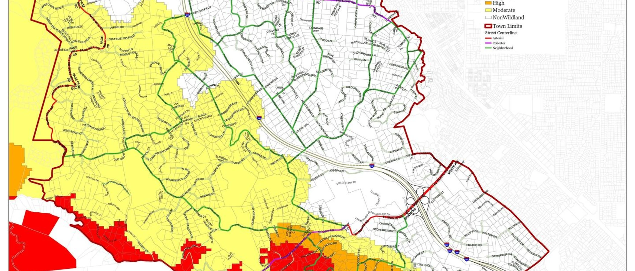
The southern and western edges of Los Altos transition sharply into foothills that connect to the Los Altos Hills and Page Mill wildland corridor.
FireRoofs Premier Home Hardening & Active Defense
FireRoofs provides premier wildfire defense and home hardening for Los Altos properties. We combine automated exterior wildfire sprinkler systems with structural hardening that addresses every ember entry point on the home. Learn more about wildfire roof sprinkler installation and how it works alongside defensible space in Los Altos.
Automated Exterior Sprinklers
Dual-detection roof and perimeter sprinklers with satellite monitoring
Ember-Resistant Vents
Retrofit vents that seal the attic from ember intrusion
Noncombustible Fencing
Eliminate the fence-to-structure flame path
Zone Zero Hardening
Clear combustible material within 5 feet of the structure
Vegetation Fire Retardant
Applied to surrounding landscape for ember resistance
Insurance Evidence Packet
Mapped to California Regulation 2644.9 for carrier submission
Los Altos borders the foothills above the Santa Clara Valley, with some residential areas extending into fire-prone terrain near Rancho San Antonio and other open space preserves. Properties in these areas face seasonal fire exposure from grassland and oak woodland. FireRoofs provides home hardening for Los Altos properties where established suburban development meets the wildland interface.
Ember-Resistant Vent Retrofit for Los Altos Homes
Los Altos foothill homes face ember exposure from grassland and oak woodland fires in adjacent open space. Legacy vents with inadequate mesh allow embers to enter attic spaces. Vulcan Vents with ASTM E2886 certification replace outdated vent assemblies with stainless steel ember mesh and intumescent sealing, meeting the Chapter 7A WUI vent standards that apply to Los Altos fire hazard zones.
Vulcan Vents - California WUI StandardsStainless Steel Gutter Guard Installation in Los Altos
Los Altos homes near the foothills collect leaf and debris from mature trees year-round. During dry fire weather, gutters become a primary ember ignition target. Our noncombustible stainless steel micro mesh gutter guards prevent debris buildup in gutters, maintaining a clean roof perimeter that the Santa Clara County FireSafe Council recommends as a frontline home hardening measure.
Santa Clara County FireSafe - Home HardeningDeck-to-Structure Ember Break for Los Altos Properties
Los Altos homes with attached wood decks have a concentrated vulnerability where the deck surface meets siding. Embers accumulate in this joint, and debris buildup ignites both surfaces. Our ember break installs noncombustible metal flashing and a hardscape gap at each deck-wall connection, creating a fireproof separation per the Safer from Wildfires framework.
CA Dept of Insurance - Safer from WildfiresOpen Eave Enclosure for Los Altos Properties
Los Altos homes with open eave construction expose rafter tails and blocking to ember intrusion. Our retrofit encloses these openings with noncombustible soffit material and WUI-rated vents meeting ASTM E2886 standards. The result seals the most common attic entry point while maintaining the ventilation Los Altos homes need for moisture control and energy efficiency.
CALBO - Chapter 7A Code ChangesNon Combustible Gate and Fence for Los Altos Homes
Wood gates and fencing on Los Altos properties can carry fire from street-side vegetation or neighboring lots directly to the home. Our noncombustible installation replaces combustible wood gates and fence sections within 5 feet of the structure with aluminum or steel alternatives. This addresses the Zone 0 noncombustible material requirement under AB 3074 while preserving the residential character of Los Altos neighborhoods.
Ready for Wildfire - Defensible SpaceWhy Home Hardening Matters in Los Altos
Properties on Los Altos’ western edge live in a risk zone that their city address does not always reflect. Insurance carriers increasingly use parcel-level risk data rather than city boundaries, which means your property may face non-renewal or rate increases even if your neighbor a few blocks east does not. FireRoofs helps western Los Altos homeowners close that gap with automated sprinkler systems and physical home hardening
Noncombustible fencing, ember-resistant vents, vegetation fire retardant, and Zone Zero landscape hardening address the specific mitigation categories that carriers recognize under Regulation 2644.9. Every upgrade documented, every category mapped.

CAL FIRE Very High Fire Hazard Severity Zones (VHFHSZ) shown in red/orange
Source: CAL FIRE Fire Hazard Severity Zone data via Bay Area News Group
CAL FIRE VHFHSZ Designation
Very High Fire Hazard Severity Zones are present in hillside and foothill portions of Los Altos. The 2025 CAL FIRE maps expanded VHFHSZ designations in Santa Clara County hillside communities. Local Responsibility Area.
Los Altos's Wildfire Record
Understanding past fires helps predict future risk. Here are the most significant fire events near Los Altos.
The SCU Lightning Complex burned in the Diablo Range to the east. Los Altos experienced smoke impacts and evacuation warnings in hillside areas but the fire did not enter the city.
No major wildfire has directly burned into Los Altos in the last 25 years, though the city has experienced smoke and ember exposure during regional fire events affecting the Santa Cruz Mountains and Diablo Range.
Local Risk Factors
Wildland-Urban Interface
Southern and western neighborhoods transition directly into the foothills and Los Altos Hills, creating WUI conditions with limited defensible space.
Adjacent Open Space
Rancho San Antonio County Park, Hidden Villa, and Foothills Nature Preserve create thousands of acres of wildland fuel adjacent to residential areas.
Diablo Wind Exposure
Diablo wind events from the north and northeast can accelerate fire spread from the foothills toward residential areas. Red Flag Warnings are issued several times per year.
Dense Vegetation
Mixed oak woodland, eucalyptus groves, and ornamental landscaping transition to wildland character near the Los Altos Hills boundary, with ground cover drying out significantly in summer and fall.
Book a free on-site evaluation. We will design and install the right sprinkler and hardening system for your home.
Book Free EvaluationAll work performed by licensed and insured contractors.
Get the $149 assessment report. Find out what wildfire risk models flag on your property. Results in minutes.
Get $149 ReportLos Altos Fire Environment
Vegetation Types
Wind Patterns
Diablo wind events from north/northeast; sundowner winds in afternoon; Red Flag Warnings several times per year
Topography
Flatlands and foothills. Southern and western portions rise into the Los Altos Hills foothills. WUI neighborhoods have moderate slopes transitioning to steeper terrain.
Fire District
Santa Clara County Fire Department
Insurance Impact
Los Altos hillside and WUI properties frequently exceed the $3 million FAIR Plan dwelling coverage cap. High-end foothill properties range from $4M to $10M+, creating significant underinsurance gaps.
Protecting Your Los Altos Home & Family
Living in a fire-prone area means being proactive. Here are the steps every Los Altos homeowner should take to protect their property and prepare for wildfire season.
Evacuation Planning
Register for AlertSCC emergency notifications. Know routes to El Camino Real, Foothill Expressway, I-280, and Highway 85. Hillside neighborhoods near Los Altos Hills have limited egress and can bottleneck during emergencies.
Defensible Space
Maintain 100 feet of defensible space per PRC 4291. SCCFD offers free WUI Preparedness Inspections through the Fire Prevention Division at 408-378-4010. Focus on removing dead vegetation and thinning tree canopy near structures.


Your Local Fire Safe Council
Santa Clara County Fire Safe Council
The Santa Clara County Fire Safe Council offers free resources, community chipping programs, home assessments, and education to help Los Altos residents reduce wildfire risk and prepare for fire season.
Visit Santa Clara County Fire Safe CouncilLos Altos Wildfire Preparedness Resources
Santa Clara County Fire Safe Council
Free chipper programs, home hardening guides, and wildfire preparedness resources.
SC County Fire Safe CouncilSCCFD Wildfire Preparedness
Free WUI Preparedness Inspections and defensible space guidance from Santa Clara County Fire Department.
SCCFDCAL FIRE Defensible Space Guide
Official California guide to creating defensible space zones around your property.
CAL FIREProtect Your Los Altos Home with FireRoofs
Defensible space and evacuation planning are essential, but they have limits. When embers are raining down and flames are approaching, your home needs both an automated active defense system and structural hardening that eliminates every ember entry point.
FireRoofs combines automated exterior sprinkler systems with structural home hardening for Los Altos properties. Our Detect → Alert → Defend system uses intelligent wildfire detection cameras, satellite monitoring, and high-pressure water to saturate your property. Our hardening scope seals every vulnerability embers exploit.
- Automated exterior sprinklers: roof and perimeter coverage with dual detection
- Ember-resistant vent retrofits to seal the attic from intrusion
- Noncombustible fencing to eliminate the fence-to-structure flame path
- Zone Zero landscape hardening within 5 feet of the structure
- Vegetation fire retardant application for surrounding landscape
- Class A firefighting foam add-on: 100% biodegradable, non-toxic, rinses off through sprinklers
- Insurance evidence packet documenting all upgrades, mapped to California Regulation 2644.9


Local Wildfire Resources for Los Altos Homeowners
Rules and requirements can change. Verify current requirements with your city or fire district before taking action.

Tree Removal and Defensible Space Rules
Los Altos requires permits for protected trees following Santa Clara County tree preservation guidelines. Exemptions exist for trees posing fire hazard risk or dead/dying trees. Standard Santa Clara County defensible space requirements apply in VHFHSZ areas.
Fire Hazard Severity Zone: Very High in hillside/foothill portions. 2025 CAL FIRE maps expanded VHFHSZ in Santa Clara County hillside communities. Local Responsibility Area.

Free Programs for Los Altos Homeowners
- SCCFD chipper programs through Santa Clara County Fire Safe Council (sccfiresafe.org)
- Free WUI Preparedness Inspections via SCCFD Fire Prevention Division (408-378-4010)
- Access to Santa Clara County Community Wildfire Protection Plan (CWPP, updated 2023)
Your Fire District
Santa Clara County Fire Department (SCCFD)
Community Designations
- Firewise USA communities in hillside neighborhoods
- Part of Santa Clara County Fire Safe Council service area
- Santa Clara County CWPP coverage
Community designations like Firewise USA and Fire Risk Reduction Community may qualify homeowners for insurance benefits under California's Safer from Wildfires regulation.

Statewide Zone 0 Compliance Timeline
Board of Forestry rulemaking targeted for completion by December 31, 2025. New construction: compliance begins once rules are adopted (projected 2026). Existing structures: 3-year phase-in (compliance expected by approximately 2028-2029).
State Defensible Space (PRC 4291)
Zone 0: 0-5 feet, ember-resistant/noncombustible. Zone 1: 5-30 feet, lean, clean, and green. Zone 2: 30-100 feet, reduced fuel loading. Annual compliance inspections by local fire districts during fire season.
California Building Code
Effective 2026, California Wildland-Urban Interface Code (CWUIC) Part 7 replaces CBC Chapter 7A. Applies to new construction in designated fire hazard zones.
How FireRoofs Fits In
Understanding your local requirements is the first step. A FireRoofs automated defense system works alongside your defensible space, home hardening, and community efforts to give your home the strongest possible protection. During your free property evaluation, our team reviews your property in the context of Los Altos's specific requirements and helps you understand how active defense fits into your overall wildfire strategy.
Nearby Communities We Serve
FireRoofs also installs wildfire defense systems in neighboring communities with similar WUI risk profiles.
2026 Insurance Alert for Los Altos Homeowners
Homeowners in Los Altos are facing surging FAIR Plan rates and non-renewals from private carriers. California's Safer from Wildfires framework now requires participating insurers to offer discounts for documented mitigation systems. FireRoofs provides the engineering documentation and evidence packet designed to help you qualify for the voluntary market.
California's SB 429 (effective January 1, 2026) establishes the nation's first public wildfire catastrophe model, giving homeowners new tools to understand insurance risk scores. Ask HydroIQ what this means for Los Altos homeowners.
Request a Free Property EvaluationAsk HydroIQ About Los Altos - Free AI Wildfire Assistant
Get instant answers about Los Altos's wildfire risk level, defensible space requirements, fire history, FAIR Plan insurance options, and how exterior sprinkler systems can protect your home. HydroIQ covers communities across all nine Bay Area counties.
Protect Your Los Altos Property Today
Every Los Altos property is different. Get a free evaluation of your home's wildfire exposure and a custom defense plan.
Common Questions
What wildfire risk does Los Altos face?
Los Altos is designated a Very High Fire Hazard Severity Zone by CAL FIRE. Santa Clara County fire maps confirm extreme exposure driven by mixed oak woodland and eucalyptus fuel loads and dry-season wind patterns. Southern and western neighborhoods transition directly into the foothills and Los Altos Hills, creating WUI conditions with limited defensible space.
How does FireRoofs protect Los Altos homes from wildfire?
FireRoofs provides both active defense and passive home hardening for Los Altos properties. Active defense includes automated exterior sprinkler systems with dual detection, satellite monitoring, and intelligent fire detection cameras. Passive hardening covers ember-resistant vent retrofits, noncombustible fencing, Zone Zero landscape hardening, exterior cladding upgrades, and vegetation fire retardant. Every upgrade is documented in one evidence packet mapped to California Regulation 2644.9 for insurance recognition.
What does home hardening include for a Los Altos property?
Home hardening for Los Altos properties addresses every ember entry point on the structure. FireRoofs performs ember-resistant vent installation, noncombustible fencing replacement, eave and soffit sealing, Zone Zero landscape clearance within 5 feet of the structure, vegetation fire retardant application, and exterior cladding upgrades where needed. Scope is determined during a free property evaluation and accounts for local terrain and elevation changes. All work is documented for insurance submission.
Where can I get instant answers about Los Altos's wildfire risk?
HydroIQ is FireRoofs' free wildfire assistant that provides instant, city-specific answers about Los Altos's fire hazard zone classification, defensible space requirements, local fire history, FAIR Plan insurance options, and wildfire defense systems. No sign-up required. Visit fireroofs.com/hydroiq to learn more or ask a question directly.
What is California home hardening?
California home hardening is the process of retrofitting a structure to resist wildfire ember intrusion and radiant heat exposure. It includes replacing combustible building materials, sealing openings such as attic vents and eaves, installing noncombustible fencing, clearing the Zone Zero perimeter within 5 feet of the structure, and applying fire-resistant treatments. Home hardening is one of the 12 mitigation categories under California Regulation 2644.9 (Safer from Wildfires) that participating insurers must recognize when setting premiums.
How do I get off the California FAIR Plan?
To transition from the California FAIR Plan back to the voluntary insurance market, homeowners need to demonstrate documented wildfire risk reduction. This includes property-level mitigation such as home hardening, automated exterior sprinkler systems, and defensible space maintenance. Under California Regulation 2644.9, admitted insurers are required to offer premium discounts for documented mitigation across 12 categories. FireRoofs provides the upgrades and the evidence packet that documents each improvement for your insurer or broker.
What are the 12 Safer from Wildfires mitigation categories?
California Regulation 2644.9 defines 12 mitigation categories that insurers must recognize: (1) Class A fire-rated roof, (2) Enclosed eaves, (3) Ember-resistant vents, (4) Exterior wall cladding, (5) Dual-pane or tempered windows, (6) Noncombustible fencing within 5 feet, (7) Defensible space Zone 0-2 maintained, (8) Community-level mitigation (Fire Risk Reduction Community), (9) Active fire defense system such as exterior sprinklers, (10) Fire-resistant landscaping, (11) Access and water supply, (12) Structure-specific risk reduction. FireRoofs addresses categories 1 through 10 directly.
Do exterior roof sprinklers qualify for insurance discounts in California?
Yes. Automated exterior sprinkler systems are recognized under Category 9 (Active Fire Defense System) of California Regulation 2644.9. When documented in an evidence packet and submitted to your insurer, they count toward the mitigation credits that admitted carriers are required to apply. FireRoofs installs dual-detection exterior sprinkler systems and provides the documentation package for insurance recognition. SB 429 (effective January 1, 2026) further supports this by establishing a public wildfire catastrophe model that factors documented improvements into risk scoring.
Is Los Altos in a Very High Fire Hazard Severity Zone?
Yes. Hillside and foothill portions of Los Altos are designated Very High FHSZ per the 2025 CAL FIRE maps. Properties in these areas are subject to defensible space requirements and enhanced building standards.
Are there free wildfire programs for Los Altos homeowners?
Yes. SCCFD offers free WUI Preparedness Inspections through the Fire Prevention Division at 408-378-4010. The Santa Clara County Fire Safe Council provides free chipper days for VHFHSZ residents at sccfiresafe.org.
Does Los Altos require tree removal permits for defensible space?
Tree removal permits are generally required, but exemptions exist for trees posing fire hazard risk or dead/dying trees. Contact the City of Los Altos planning department for specific guidance on your property.