Pleasanton Wildfire Defense
Pleasanton's fire risk concentrates along its eastern ridgeline where the Tri-Valley suburbs end and the Diablo Range grasslands begin. The Castlewood, Ruby Hill, and Foothill Road neighborhoods sit at elevations between 400 and 800 feet, directly exposed to dry east winds that funnel through Niles Canyon and Sunol Grade. The Livermore-Pleasanton Fire Department responds to 15-25 grass fires per year in the surrounding hills, most during July through October. In 2023, a ridge fire near the Pleasanton Ridge Regional Park forced pre-evacuation warnings for Foothill Road residents. These are not remote properties. They are $2-4 million homes within 10 minutes of downtown.
$149 Wildfire Report for Pleasanton Homeowners
See what California wildfire codes require for your Pleasanton property. Covers roof, vents, defensible space, and insurance paperwork. Get your report in minutes.
CAL FIRE Risk Designation
Alameda County
Pleasanton's eastern ridgeline neighborhoods face direct exposure to Diablo Range grassland fires, with 15-25 grass fires per year in surrounding hills.
FireRoofs Premier Home Hardening & Active Defense
FireRoofs provides premier wildfire defense and home hardening for Pleasanton properties. We combine automated exterior sprinkler systems with structural hardening that addresses every ember entry point on the home.
Automated Exterior Sprinklers
Dual-detection roof and perimeter sprinklers with satellite monitoring
Ember-Resistant Vents
Retrofit vents that seal the attic from ember intrusion
Noncombustible Fencing
Eliminate the fence-to-structure flame path
Zone Zero Hardening
Clear combustible material within 5 feet of the structure
Vegetation Fire Retardant
Applied to surrounding landscape for ember resistance
Insurance Evidence Packet
Mapped to California Regulation 2644.9 for carrier submission
Pleasanton edges into the fire-prone hillsides of the Pleasanton Ridge and Sunol Valley, where dry grassland and blue oak woodland create significant seasonal fire risk. Hot summer temperatures, low humidity, and seasonal wind events push fire toward residential areas along the western and southern edges of the city. FireRoofs provides hardening specific to Pleasanton's grassland-exposure and established construction.
Vulcan Vents Vent Retrofit for Pleasanton Homes
Pleasanton homes along the Pleasanton Ridge face wind-driven ember exposure from fast-moving grassland fires. Standard attic vents allow embers to enter and ignite insulation and stored materials. Vulcan Vents replace inadequate mesh with ASTM E2886-certified assemblies featuring stainless steel ember screening and intumescent sealing technology, providing the dual-layer protection Pleasanton WUI properties require under current California building standards.
Vulcan Vents - WUI ComplianceStainless Steel Gutter Guard Installation in Pleasanton
Pleasanton homes in foothills neighborhoods collect dry oak leaves and grass debris in gutters that become extreme fire hazards during summer. Our stainless steel micro mesh gutter guards are noncombustible and prevent all debris accumulation, eliminating the gutter fuel bed that grassland fire embers target first. This is one of the most cost-effective hardening measures for Pleasanton homes near the wildland interface.
Fire Safe Marin - Gutter HardeningNon Combustible Fencing for Pleasanton WUI Properties
Wood fencing along the Pleasanton Ridge interface creates direct fire pathways from grassland to homes. Our noncombustible fencing installation replaces combustible wood sections within 5 feet of the structure with steel or aluminum panels meeting ASTM E136 standards. This Zone 0 compliance measure eliminates the fence-line fire transfer that is one of the most common causes of structure ignition during grass fires.
Ready for Wildfire - Defensible SpaceNoncombustible Fuelbreak Installation in Pleasanton
Pleasanton homes at the urban-wildland edge often have bark mulch, ornamental grass, and dried plantings extending to the foundation wall. Our fuelbreak replaces combustible materials within the 0-5 foot Zone 0 perimeter with gravel, decomposed granite, or pavers. For Pleasanton properties exposed to fast-moving grass fire, this treatment denies embers the foundation-level fuel that leads to wall ignition.
Board of Forestry - Zone 0 StandardsNon Combustible Gate Installation for Pleasanton Properties
Pleasanton properties with wood entry gates and side gates create fire entry points that bypass landscaping and defensible space. Our noncombustible gate installation replaces combustible wood gates with steel or aluminum alternatives designed to withstand direct flame contact. Combined with noncombustible fencing at the Zone 0 perimeter, this eliminates the gate-to-structure fire pathway on Pleasanton homes.
CA Dept of Insurance - Safer from WildfiresWhy Home Hardening Matters in Pleasanton
The SCU Lightning Complex proved that the Tri-Valley is not immune to large-scale wildfire. Pleasanton’s eastern hill homeowners need both active defense and physical hardening to protect their properties and maintain their insurance coverage
FireRoofs provides both, documented for carrier review.

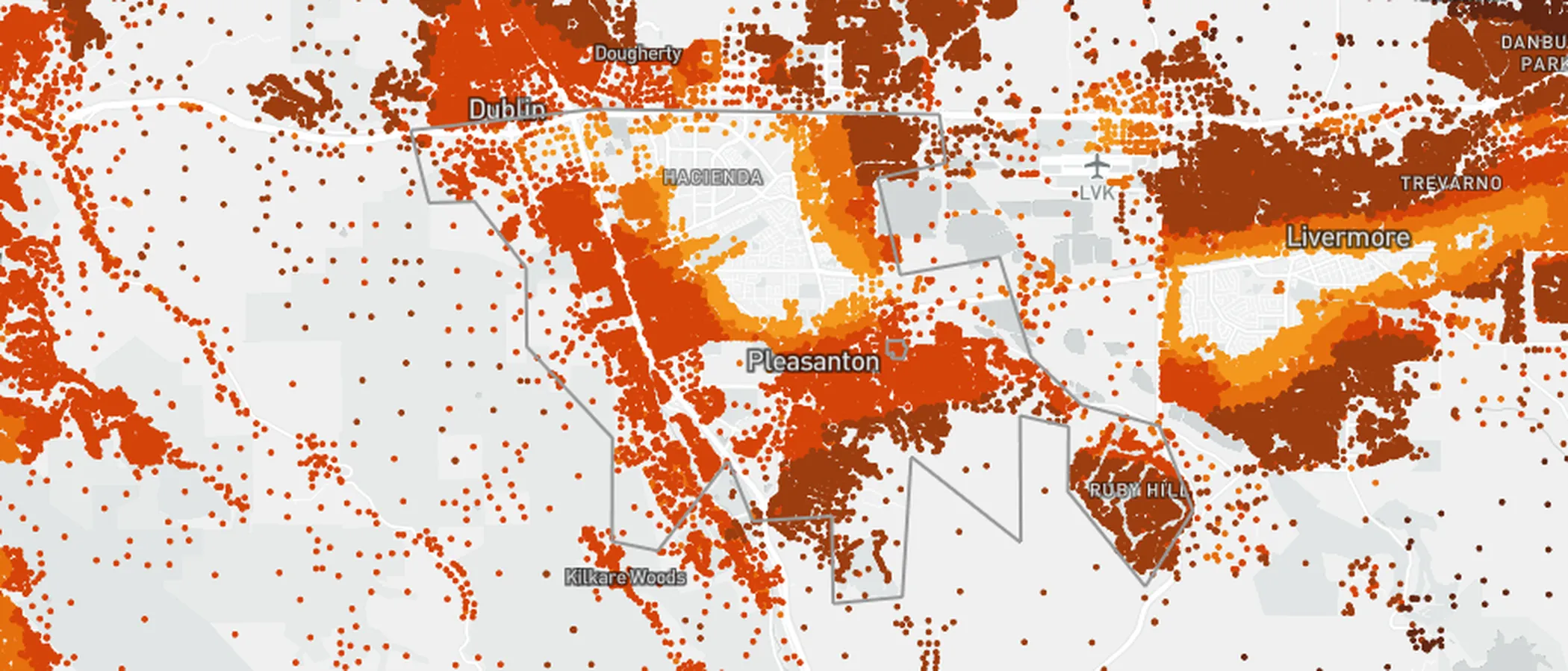
CAL FIRE Very High Fire Hazard Severity Zones (VHFHSZ) shown in red/orange
Source: CAL FIRE Fire Hazard Severity Zone data via Bay Area News Group
CAL FIRE High Fire Hazard Severity Zone
Portions of Pleasanton fall within CAL FIRE Fire Hazard Severity Zone designations, primarily along the eastern ridgeline and areas bordering Pleasanton Ridge Regional Preserve.
Pleasanton's Wildfire Record
Understanding past fires helps predict future risk. Here are the most significant fire events near Pleasanton.
Burned 396,625 acres in the hills east of Pleasanton, triggering evacuation warnings for eastern neighborhoods and demonstrating the Tri-Valley's fire vulnerability.
Burned 90,288 acres in Yolo and Napa Counties, with smoke blanketing the Tri-Valley for weeks and demonstrating Diablo wind fire behavior.
Grass fire burned several hundred acres on the ridgeline directly above Pleasanton neighborhoods, triggering evacuations.
Local Risk Factors
Diablo Wind Exposure
Pleasanton is directly in the path of hot, dry Diablo winds that funnel through Altamont Pass and down through the Tri-Valley, creating extreme fire conditions.
Grassland Fire Speed
Surrounding annual grasslands cure completely by June and can support fire spread rates of 300+ acres per hour in wind-driven conditions.
Ridgeline Development
Eastern Pleasanton neighborhoods are built along the ridgeline with wildland on multiple sides, limited defensible space, and narrow access roads.
Open Space Adjacency
Pleasanton Ridge Regional Preserve and Augustin Bernal Park border residential areas, creating continuous fuel loads from wildland to structures.
Book a free on-site evaluation. We will design and install the right sprinkler and hardening system for your home.
Book Free EvaluationGet the $149 assessment report. Find out what wildfire risk models flag on your property. Results in minutes.
Get $149 ReportPleasanton Fire Environment
Vegetation Types
Wind Patterns
Strong Diablo winds (NE) in fall through Altamont Pass; valley thermals in summer
Topography
Elevation ranges from 350 ft in the valley to 1,600 ft on Pleasanton Ridge. West-facing slopes create direct exposure for residential areas.
Fire District
Livermore-Pleasanton Fire Department
Insurance Impact
Ridgeline and WUI-adjacent properties in Pleasanton are seeing increasing insurance non-renewals, with some homeowners forced to the FAIR Plan.
Protecting Your Pleasanton Home & Family
Living in a fire-prone area means being proactive. Here are the steps every Pleasanton homeowner should take to protect their property and prepare for wildfire season.
Evacuation Planning
Pleasanton's ridgeline neighborhoods have limited exit routes. Register for AC Alert and know your Zonehaven evacuation zone. During Diablo wind events, eastside roads can gridlock quickly. Have a go-bag packed and leave at the first warning. don't wait for mandatory evacuation.
Defensible Space
Maintain 100 feet of defensible space, especially on the slope-facing side of your property. The Diablo Fire Safe Council offers cost-sharing for vegetation clearing. Keep grass mowed below 4 inches from May through November and remove all dead vegetation within 30 feet of structures.


Your Local Fire Safe Council
Diablo Fire Safe Council
The Diablo Fire Safe Council offers free resources, community chipping programs, home assessments, and education to help Pleasanton residents reduce wildfire risk and prepare for fire season.
Visit Diablo Fire Safe CouncilPleasanton Wildfire Preparedness Resources
Diablo Fire Safe Council
Up to $3,500 in cost-sharing for vegetation clearing, Firewise community support, and education programs.
Diablo FSCLivermore-Pleasanton Fire Department
Wildfire preparedness resources, defensible space requirements, and FHSZ maps for Pleasanton and Livermore.
LPFDCAL FIRE Defensible Space Guide
Official California guide to creating defensible space zones around your property.
CAL FIREProtect Your Pleasanton Home with FireRoofs
Defensible space and evacuation planning are essential, but they have limits. When embers are raining down and flames are approaching, your home needs both an automated active defense system and structural hardening that eliminates every ember entry point.
FireRoofs combines automated exterior sprinkler systems with structural home hardening for Pleasanton properties. Our Detect → Alert → Defend system uses intelligent wildfire detection cameras, satellite monitoring, and high-pressure water to saturate your property. Our hardening scope seals every vulnerability embers exploit.
- Automated exterior sprinklers: roof and perimeter coverage with dual detection
- Ember-resistant vent retrofits to seal the attic from intrusion
- Noncombustible fencing to eliminate the fence-to-structure flame path
- Zone Zero landscape hardening within 5 feet of the structure
- Vegetation fire retardant application for surrounding landscape
- Class A firefighting foam add-on: 100% biodegradable, non-toxic, rinses off through sprinklers
- Insurance evidence packet documenting all upgrades, mapped to California Regulation 2644.9


Local Wildfire Resources for Pleasanton Homeowners
Rules and requirements can change. Verify current requirements with your city or fire district before taking action.

Tree Removal and Defensible Space Rules
City tree permits with fire hazard exemptions. Follows PRC 4291 for defensible space.
Fire Hazard Severity Zone: Very High in hillside/ridge areas. Local Responsibility Area.

Free Programs for Pleasanton Homeowners
- Diablo Fire Safe Council programs

Statewide Zone 0 Compliance Timeline
Board of Forestry rulemaking targeted for completion by December 31, 2025. New construction: compliance begins once rules are adopted (projected 2026). Existing structures: 3-year phase-in (compliance expected by approximately 2028-2029).
State Defensible Space (PRC 4291)
Zone 0: 0-5 feet, ember-resistant/noncombustible. Zone 1: 5-30 feet, lean, clean, and green. Zone 2: 30-100 feet, reduced fuel loading. Annual compliance inspections by local fire districts during fire season.
California Building Code
Effective 2026, California Wildland-Urban Interface Code (CWUIC) Part 7 replaces CBC Chapter 7A. Applies to new construction in designated fire hazard zones.
How FireRoofs Fits In
Understanding your local requirements is the first step. A FireRoofs automated defense system works alongside your defensible space, home hardening, and community efforts to give your home the strongest possible protection. During your free property evaluation, our team reviews your property in the context of Pleasanton's specific requirements and helps you understand how active defense fits into your overall wildfire strategy.
Nearby Communities We Serve
FireRoofs also installs wildfire defense systems in neighboring communities with similar WUI risk profiles.
2026 Insurance Alert for Pleasanton Homeowners
Homeowners in Pleasanton are facing surging FAIR Plan rates and non-renewals from private carriers. California's Safer from Wildfires framework now requires participating insurers to offer discounts for documented mitigation systems. FireRoofs provides the engineering documentation and evidence packet designed to help you qualify for the voluntary market.
California's SB 429 (effective January 1, 2026) establishes the nation's first public wildfire catastrophe model, giving homeowners new tools to understand insurance risk scores. Ask HydroIQ what this means for Pleasanton homeowners.
Request a Free Property EvaluationAsk HydroIQ About Pleasanton - Free AI Wildfire Assistant
Get instant answers about Pleasanton's wildfire risk level, defensible space requirements, fire history, FAIR Plan insurance options, and how exterior sprinkler systems can protect your home. HydroIQ covers communities across all nine Bay Area counties.
Protect Your Pleasanton Property Today
Every Pleasanton property is different. Get a free evaluation of your home's wildfire exposure and a custom defense plan.
Common Questions
What wildfire risk does Pleasanton face?
Pleasanton is designated a High fire risk zone by CAL FIRE. Alameda County fire maps confirm elevated exposure driven by annual grassland and blue oak savanna fuel loads and dry-season wind patterns. Pleasanton is directly in the path of hot, dry Diablo winds that funnel through Altamont Pass and down through the Tri-Valley, creating extreme fire conditions.
How does FireRoofs protect Pleasanton homes from wildfire?
FireRoofs provides both active defense and passive home hardening for Pleasanton properties. Active defense includes automated exterior sprinkler systems with dual detection, satellite monitoring, and intelligent fire detection cameras. Passive hardening covers ember-resistant vent retrofits, noncombustible fencing, Zone Zero landscape hardening, exterior cladding upgrades, and vegetation fire retardant. Every upgrade is documented in one evidence packet mapped to California Regulation 2644.9 for insurance recognition.
What does home hardening include for a Pleasanton property?
Home hardening for Pleasanton properties addresses every ember entry point on the structure. FireRoofs performs ember-resistant vent installation, noncombustible fencing replacement, eave and soffit sealing, Zone Zero landscape clearance within 5 feet of the structure, vegetation fire retardant application, and exterior cladding upgrades where needed. Scope is determined during a free property evaluation and accounts for local terrain and elevation changes. All work is documented for insurance submission.
Where can I get instant answers about Pleasanton's wildfire risk?
HydroIQ is FireRoofs' free wildfire assistant that provides instant, city-specific answers about Pleasanton's fire hazard zone classification, defensible space requirements, local fire history, FAIR Plan insurance options, and wildfire defense systems. No sign-up required. Visit fireroofs.com/hydroiq to learn more or ask a question directly.
What is California home hardening?
California home hardening is the process of retrofitting a structure to resist wildfire ember intrusion and radiant heat exposure. It includes replacing combustible building materials, sealing openings such as attic vents and eaves, installing noncombustible fencing, clearing the Zone Zero perimeter within 5 feet of the structure, and applying fire-resistant treatments. Home hardening is one of the 12 mitigation categories under California Regulation 2644.9 (Safer from Wildfires) that participating insurers must recognize when setting premiums.
How do I get off the California FAIR Plan?
To transition from the California FAIR Plan back to the voluntary insurance market, homeowners need to demonstrate documented wildfire risk reduction. This includes property-level mitigation such as home hardening, automated exterior sprinkler systems, and defensible space maintenance. Under California Regulation 2644.9, admitted insurers are required to offer premium discounts for documented mitigation across 12 categories. FireRoofs provides the upgrades and the evidence packet that documents each improvement for your insurer or broker.
What are the 12 Safer from Wildfires mitigation categories?
California Regulation 2644.9 defines 12 mitigation categories that insurers must recognize: (1) Class A fire-rated roof, (2) Enclosed eaves, (3) Ember-resistant vents, (4) Exterior wall cladding, (5) Dual-pane or tempered windows, (6) Noncombustible fencing within 5 feet, (7) Defensible space Zone 0-2 maintained, (8) Community-level mitigation (Fire Risk Reduction Community), (9) Active fire defense system such as exterior sprinklers, (10) Fire-resistant landscaping, (11) Access and water supply, (12) Structure-specific risk reduction. FireRoofs addresses categories 1 through 10 directly.
Do exterior roof sprinklers qualify for insurance discounts in California?
Yes. Automated exterior sprinkler systems are recognized under Category 9 (Active Fire Defense System) of California Regulation 2644.9. When documented in an evidence packet and submitted to your insurer, they count toward the mitigation credits that admitted carriers are required to apply. FireRoofs installs dual-detection exterior sprinkler systems and provides the documentation package for insurance recognition. SB 429 (effective January 1, 2026) further supports this by establishing a public wildfire catastrophe model that factors documented improvements into risk scoring.
What wildfire programs are available in Pleasanton?
The Diablo Fire Safe Council offers programs for hillside residents. The Livermore-Pleasanton Fire Department conducts defensible space inspections in VHFHSZ areas. Contact your fire department for current requirements.