Dublin Wildfire Defense
Dublin's fire risk became front-page news in 2025 when the Parks Fire burned 118 acres along the Dublin-San Ramon border, forcing evacuations and destroying vegetation within sight of suburban backyards. The fire confirmed what fire officials had been warning about: Dublin's northern ridgeline and its southern and eastern boundaries transition into vast grassland that ignites readily during summer. The Camp Parks Military Reserve and Tassajara Hills areas create large undeveloped fuel beds adjacent to some of Dublin's newest housing developments. These are homes built in the last 10-15 years, with compliant roofing but often with wood fencing, standard vents, and minimal defensible space.
$149 Wildfire Report for Dublin Homeowners
See what California wildfire codes require for your Dublin property. Covers roof, vents, defensible space, and insurance paperwork. Get your report in minutes.
CAL FIRE Risk Designation
Alameda County
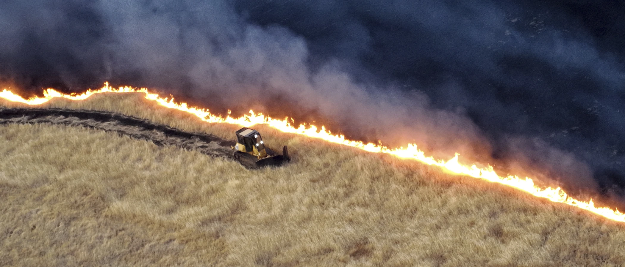
The 2025 Parks Fire burned 118 acres along the Dublin-San Ramon border, forcing evacuations of homes in some of Dublin's newest housing developments.
FireRoofs Premier Home Hardening & Active Defense
FireRoofs provides premier wildfire defense and home hardening for Dublin properties. We combine automated exterior wildfire sprinkler systems with structural hardening that addresses every ember entry point on the home. Learn more about wildfire roof sprinkler installation and how it works alongside defensible space in Dublin.
Automated Exterior Sprinklers
Dual-detection roof and perimeter sprinklers with satellite monitoring
Ember-Resistant Vents
Retrofit vents that seal the attic from ember intrusion
Noncombustible Fencing
Eliminate the fence-to-structure flame path
Zone Zero Hardening
Clear combustible material within 5 feet of the structure
Vegetation Fire Retardant
Applied to surrounding landscape for ember resistance
Insurance Evidence Packet
Mapped to California Regulation 2644.9 for carrier submission
Dublin borders the East Bay regional parklands and grassland hills to the east and south, with newer residential developments extending into terrain that faces seasonal fire risk from dry grass and chaparral. The combination of Diablo wind events and rapid suburban development at the wildland interface makes structural hardening a priority for Dublin homeowners.
EmberSafe Gutter Guard Installation in Dublin
Dublin homes on the city's eastern edge collect windblown grass debris and fine fuels in gutters during the long dry season. These combustible deposits ignite from embers carried by Diablo winds. Our stainless steel micro mesh gutter guards prevent fuel accumulation in gutters, maintaining a noncombustible roof perimeter that denies embers their most common ignition target on Dublin residential properties.
Fire Safe Marin - Gutter Fire ProtectionEmber-Resistant Vent Retrofit for Dublin Homes
Dublin properties facing the grassland hills are exposed to ember showers during wind-driven fire events. Even newer construction may have vent configurations that fall short of ASTM E2886 standards. Vulcan Vents provide California State Fire Marshal-listed, ASTM E2886-certified ember and flame protection that exceeds minimum code requirements, with intumescent technology that activates under fire conditions.
Vulcan Vents - WUI StandardsNon Combustible Fencing Installation in Dublin
Dublin neighborhoods feature extensive wood fencing along property lines and backing to open space. This creates continuous combustible pathways from wildland to structures. Our noncombustible fencing installation replaces wood fence sections within 5 feet of the home with steel or aluminum panels meeting ASTM E136 standards, satisfying Zone 0 noncombustible material requirements under AB 3074.
Ready for Wildfire - Defensible Space GuideOpen Eave Enclosure for Dublin Properties
Older Dublin homes and some newer construction have eave configurations that allow wind-driven embers to enter the roof structure. Our eave enclosure retrofit installs noncombustible soffit material with WUI-rated vents that meet ASTM E2886 standards, converting vulnerable eave construction to the enclosed configuration required by California Building Code Chapter 7A for properties in fire hazard zones.
CALBO - Chapter 7A StandardsNoncombustible Landscape Fuelbreak for Dublin Homes
Dublin properties backing to open space frequently have bark mulch and ornamental plantings extending to the foundation. During grass fire events, embers landing in this combustible material within feet of the home create immediate structural exposure. Our fuelbreak replaces organic materials within Zone 0 with noncombustible gravel or decomposed granite, meeting AB 3074 requirements.
Board of Forestry - Zone 0 ProgramWhy Home Hardening Matters in Dublin
The 2025 Camp Parks fire made the threat immediate and visible for Dublin homeowners
FireRoofs provides automated defense and premier hardening for the eastern hillside properties, documented for insurance review.

CAL FIRE Very High Fire Hazard Severity Zones (VHFHSZ) shown in red/orange
Source: CAL FIRE Fire Hazard Severity Zone data via Bay Area News Group
CAL FIRE High Fire Hazard Severity Zone
Very High and High FHSZ in northern ridgelines (Dublin Hills) and eastern transition areas. Valley floor is Moderate or not designated. Updated per 2025 CAL FIRE maps. Local Responsibility Area.
Dublin's Wildfire Record
Understanding past fires helps predict future risk. Here are the most significant fire events near Dublin.
118 acres burned east of Dougherty Road and Bollinger Canyon Road near Camp Parks training facility along the Dublin-San Ramon border. Forward progress stopped same day with coordinated CAL FIRE, ACFD, and SRVFPD response.
91.2 acres burned in Tassajara Valley near Highland Road and Collier Canyon in Dublin. PG&E crews responded to low utility lines during the incident.
The SCU Lightning Complex perimeter came close to Dublin's eastern edges but did not enter the city. Smoke and air quality impacts affected the community.
Local Risk Factors
Northern Ridgeline Exposure
Dublin Hills Regional Park and northern ridgelines create WUI conditions. Very High and High FHSZ in northern ridgelines and eastern transition areas.
Fast-Moving Grass Fires
Annual grassland dominates the surrounding hills, creating significant fuel loading. The 2025 Parks Fire and 2022 Tassajara Vegetation Fire demonstrated this risk.
Camp Parks Wildland Buffer
The 2,485-acre Camp Parks Reserve Forces Training Area adjacent to Dublin contains significant grass and brushland that could fuel fires spreading into residential areas.
Diablo Wind Exposure
Tri-Valley location exposes Dublin to Diablo wind-driven grass fire potential during fall fire season with regular Red Flag Warnings.
Book a free on-site evaluation. We will design and install the right sprinkler and hardening system for your home.
Book Free EvaluationAll work performed by licensed and insured contractors.
Get the $149 assessment report. Find out what wildfire risk models flag on your property. Results in minutes.
Get $149 ReportDublin Fire Environment
Vegetation Types
Wind Patterns
Diablo wind exposure from the east; Tri-Valley wind-driven grass fire potential; regular Red Flag Warnings during fire season
Topography
Valley floor in the city core with northern ridgelines (Dublin Hills) and eastern developing areas on varied terrain. Fallon Road and eastern hillsides have growing exposure as development expands.
Fire District
Alameda County Fire Department (contract)
Insurance Impact
Dublin home values are moderate to high. Newer developments in eastern Dublin (Positano, Wallis Ranch, Schaefer Ranch) have homes commonly $1.5M-$3M. Some luxury properties approach or exceed the $3M FAIR Plan cap.
Protecting Your Dublin Home & Family
Living in a fire-prone area means being proactive. Here are the steps every Dublin homeowner should take to protect their property and prepare for wildfire season.
Evacuation Planning
Primary routes include I-580, I-680, Dublin Boulevard, Tassajara Road, Fallon Road, and Dougherty Road. Northern ridgeline and eastern developing areas have more limited access. Register for AC Alert emergency notifications.
Defensible Space
ACFD conducts defensible space inspections through its contract service. Dublin adopted updated 2025 Fire Hazard Severity Zone Maps. Maintain 100 feet of defensible space around structures in designated areas.


Your Local Fire Safe Council
Diablo Firesafe Council
The Diablo Firesafe Council offers free resources, community chipping programs, home assessments, and education to help Dublin residents reduce wildfire risk and prepare for fire season.
Visit Diablo Firesafe CouncilDublin Wildfire Preparedness Resources
City of Dublin FHSZ Maps
Official Fire Hazard Severity Zone maps and building code requirements for Dublin properties.
City of DublinDiablo Firesafe Council
Regional wildfire planning, community education, and defensible space resources.
Diablo Firesafe CouncilCAL FIRE Defensible Space Guide
Official California guide to creating defensible space zones around your property.
CAL FIREProtect Your Dublin Home with FireRoofs
Defensible space and evacuation planning are essential, but they have limits. When embers are raining down and flames are approaching, your home needs both an automated active defense system and structural hardening that eliminates every ember entry point.
FireRoofs combines automated exterior sprinkler systems with structural home hardening for Dublin properties. Our Detect → Alert → Defend system uses intelligent wildfire detection cameras, satellite monitoring, and high-pressure water to saturate your property. Our hardening scope seals every vulnerability embers exploit.
- Automated exterior sprinklers: roof and perimeter coverage with dual detection
- Ember-resistant vent retrofits to seal the attic from intrusion
- Noncombustible fencing to eliminate the fence-to-structure flame path
- Zone Zero landscape hardening within 5 feet of the structure
- Vegetation fire retardant application for surrounding landscape
- Class A firefighting foam add-on: 100% biodegradable, non-toxic, rinses off through sprinklers
- Insurance evidence packet documenting all upgrades, mapped to California Regulation 2644.9


Local Wildfire Resources for Dublin Homeowners
Rules and requirements can change. Verify current requirements with your city or fire district before taking action.

Tree Removal and Defensible Space Rules
Dublin city code with fire hazard exemptions. ACFD enforces defensible space through contract service. Dublin adopted updated 2025 Fire Hazard Severity Zone Maps.
Fire Hazard Severity Zone: Very High and High FHSZ in northern ridgelines (Dublin Hills) and eastern transition areas. Valley floor is Moderate or not designated. Updated per 2025 CAL FIRE maps. Local Responsibility Area.

Free Programs for Dublin Homeowners
- ACFD defensible space inspections
- Diablo Firesafe Council programs
- Regional chipper programs
Your Fire District
Alameda County Fire Department (ACFD, under contract)
Community Designations
- Potential Firewise USA in hillside neighborhoods
- Part of Alameda County CWPP
Community designations like Firewise USA and Fire Risk Reduction Community may qualify homeowners for insurance benefits under California's Safer from Wildfires regulation.

Statewide Zone 0 Compliance Timeline
Board of Forestry rulemaking targeted for completion by December 31, 2025. New construction: compliance begins once rules are adopted (projected 2026). Existing structures: 3-year phase-in (compliance expected by approximately 2028-2029).
State Defensible Space (PRC 4291)
Zone 0: 0-5 feet, ember-resistant/noncombustible. Zone 1: 5-30 feet, lean, clean, and green. Zone 2: 30-100 feet, reduced fuel loading. Annual compliance inspections by local fire districts during fire season.
California Building Code
Effective 2026, California Wildland-Urban Interface Code (CWUIC) Part 7 replaces CBC Chapter 7A. Applies to new construction in designated fire hazard zones.
How FireRoofs Fits In
Understanding your local requirements is the first step. A FireRoofs automated defense system works alongside your defensible space, home hardening, and community efforts to give your home the strongest possible protection. During your free property evaluation, our team reviews your property in the context of Dublin's specific requirements and helps you understand how active defense fits into your overall wildfire strategy.
Nearby Communities We Serve
FireRoofs also installs wildfire defense systems in neighboring communities with similar WUI risk profiles.
2026 Insurance Alert for Dublin Homeowners
Homeowners in Dublin are facing surging FAIR Plan rates and non-renewals from private carriers. California's Safer from Wildfires framework now requires participating insurers to offer discounts for documented mitigation systems. FireRoofs provides the engineering documentation and evidence packet designed to help you qualify for the voluntary market.
California's SB 429 (effective January 1, 2026) establishes the nation's first public wildfire catastrophe model, giving homeowners new tools to understand insurance risk scores. Ask HydroIQ what this means for Dublin homeowners.
Request a Free Property EvaluationAsk HydroIQ About Dublin - Free AI Wildfire Assistant
Get instant answers about Dublin's wildfire risk level, defensible space requirements, fire history, FAIR Plan insurance options, and how exterior sprinkler systems can protect your home. HydroIQ covers communities across all nine Bay Area counties.
Protect Your Dublin Property Today
Every Dublin property is different. Get a free evaluation of your home's wildfire exposure and a custom defense plan.
Common Questions
What wildfire risk does Dublin face?
Dublin is designated a High fire risk zone by CAL FIRE. Alameda County fire maps confirm elevated exposure driven by annual grassland and scattered oak woodland fuel loads and dry-season wind patterns. Dublin Hills Regional Park and northern ridgelines create WUI conditions. Very High and High FHSZ in northern ridgelines and eastern transition areas.
How does FireRoofs protect Dublin homes from wildfire?
FireRoofs provides both active defense and passive home hardening for Dublin properties. Active defense includes automated exterior sprinkler systems with dual detection, satellite monitoring, and intelligent fire detection cameras. Passive hardening covers ember-resistant vent retrofits, noncombustible fencing, Zone Zero landscape hardening, exterior cladding upgrades, and vegetation fire retardant. Every upgrade is documented in one evidence packet mapped to California Regulation 2644.9 for insurance recognition.
What does home hardening include for a Dublin property?
Home hardening for Dublin properties addresses every ember entry point on the structure. FireRoofs performs ember-resistant vent installation, noncombustible fencing replacement, eave and soffit sealing, Zone Zero landscape clearance within 5 feet of the structure, vegetation fire retardant application, and exterior cladding upgrades where needed. Scope is determined during a free property evaluation and accounts for site-specific conditions including lot size and exposure. All work is documented for insurance submission.
Where can I get instant answers about Dublin's wildfire risk?
HydroIQ is FireRoofs' free wildfire assistant that provides instant, city-specific answers about Dublin's fire hazard zone classification, defensible space requirements, local fire history, FAIR Plan insurance options, and wildfire defense systems. No sign-up required. Visit fireroofs.com/hydroiq to learn more or ask a question directly.
What is California home hardening?
California home hardening is the process of retrofitting a structure to resist wildfire ember intrusion and radiant heat exposure. It includes replacing combustible building materials, sealing openings such as attic vents and eaves, installing noncombustible fencing, clearing the Zone Zero perimeter within 5 feet of the structure, and applying fire-resistant treatments. Home hardening is one of the 12 mitigation categories under California Regulation 2644.9 (Safer from Wildfires) that participating insurers must recognize when setting premiums.
How do I get off the California FAIR Plan?
To transition from the California FAIR Plan back to the voluntary insurance market, homeowners need to demonstrate documented wildfire risk reduction. This includes property-level mitigation such as home hardening, automated exterior sprinkler systems, and defensible space maintenance. Under California Regulation 2644.9, admitted insurers are required to offer premium discounts for documented mitigation across 12 categories. FireRoofs provides the upgrades and the evidence packet that documents each improvement for your insurer or broker.
What are the 12 Safer from Wildfires mitigation categories?
California Regulation 2644.9 defines 12 mitigation categories that insurers must recognize: (1) Class A fire-rated roof, (2) Enclosed eaves, (3) Ember-resistant vents, (4) Exterior wall cladding, (5) Dual-pane or tempered windows, (6) Noncombustible fencing within 5 feet, (7) Defensible space Zone 0-2 maintained, (8) Community-level mitigation (Fire Risk Reduction Community), (9) Active fire defense system such as exterior sprinklers, (10) Fire-resistant landscaping, (11) Access and water supply, (12) Structure-specific risk reduction. FireRoofs addresses categories 1 through 10 directly.
Do exterior roof sprinklers qualify for insurance discounts in California?
Yes. Automated exterior sprinkler systems are recognized under Category 9 (Active Fire Defense System) of California Regulation 2644.9. When documented in an evidence packet and submitted to your insurer, they count toward the mitigation credits that admitted carriers are required to apply. FireRoofs installs dual-detection exterior sprinkler systems and provides the documentation package for insurance recognition. SB 429 (effective January 1, 2026) further supports this by establishing a public wildfire catastrophe model that factors documented improvements into risk scoring.
Has Dublin experienced recent wildfires?
Yes. The 2025 Parks Fire burned 118 acres along the Dublin-San Ramon border near Camp Parks. The 2022 Tassajara Vegetation Fire burned 91.2 acres in Tassajara Valley. Both fires demonstrated Dublin's grass fire vulnerability.
Which parts of Dublin face the highest fire risk?
Northern ridgelines near Dublin Hills Regional Park and eastern developing areas have the highest risk. Newer communities along Fallon Road and near Tassajara Valley have growing exposure as development expands into the WUI.
What fire service does Dublin receive?
Dublin is served by Alameda County Fire Department under contract. ACFD provides all fire protection, emergency medical, and wildfire services. Dublin adopted the updated 2025 FHSZ maps.