San Ramon Wildfire Defense
San Ramon occupies a unique position in the Tri-Valley fire landscape. Its western ridgeline neighborhoods in Dougherty Valley and Crow Canyon face the same East Bay hills fire corridor that threatened Oakland in 1991, while its eastern edge backs onto open grassland extending toward Mount Diablo. The San Ramon Valley Fire Protection District holds a rare Class 1 ISO rating, the highest fire protection classification possible, and has deployed BurnBot masticator technology for vegetation management. Despite these investments, the district manages over 6,000 parcels through its Exterior Hazard Abatement program because the wildland fuel load continues to grow.
$149 Wildfire Report for San Ramon Homeowners
See what California wildfire codes require for your San Ramon property. Covers roof, vents, defensible space, and insurance paperwork. Get your report in minutes.
parcels in the Exterior Hazard Abatement program
Contra Costa County
San Ramon's fire district holds a rare Class 1 ISO rating, but the 6,000+ parcels in its Hazard Abatement program reflect the persistent wildland fuel challenge.
FireRoofs Premier Home Hardening & Active Defense
FireRoofs provides premier wildfire defense and home hardening for San Ramon properties. We combine automated exterior wildfire sprinkler systems with structural hardening that addresses every ember entry point on the home. Learn more about wildfire roof sprinkler installation and how it works alongside defensible space in San Ramon.
Automated Exterior Sprinklers
Dual-detection roof and perimeter sprinklers with satellite monitoring
Ember-Resistant Vents
Retrofit vents that seal the attic from ember intrusion
Noncombustible Fencing
Eliminate the fence-to-structure flame path
Zone Zero Hardening
Clear combustible material within 5 feet of the structure
Vegetation Fire Retardant
Applied to surrounding landscape for ember resistance
Insurance Evidence Packet
Mapped to California Regulation 2644.9 for carrier submission
San Ramon extends into the rolling hills of the Dougherty Valley and the Diablo Range foothills, where grassland and oak woodland create direct wildfire exposure for residential neighborhoods. Diablo wind events drive fast-moving fire toward the city's eastern and southern edges. FireRoofs provides hardening solutions tailored to San Ramon's specific terrain and fire behavior patterns.
Vulcan Vents Retrofit for San Ramon Homes
San Ramon homes at the edge of the Diablo Range face ember exposure from wind-driven grassland fires. Standard vents allow embers to enter attic spaces where stored items and insulation provide ready fuel. Vulcan Vents with ASTM E2886 testing replace vulnerable vents with assemblies that block embers through stainless steel mesh and seal completely under fire conditions with intumescent technology.
Vulcan Vents - Code ComplianceMicro Mesh Gutter Guard Installation in San Ramon
San Ramon properties near the hills accumulate dry grass and oak leaf debris in gutters during the long dry season. This combustible material ignites from embers before most homeowners can evacuate. Our stainless steel micro mesh gutter guards maintain a noncombustible gutter line year-round, eliminating the most accessible ignition target on San Ramon homes exposed to grassland fire.
Fire Safe Marin - Fire-Resistant GuttersNon Combustible Gate and Fence Installation in San Ramon
San Ramon residential developments commonly feature wood privacy fencing and entry gates that create continuous fire pathways between neighboring homes and from wildland to structures. Our noncombustible gate and fence installation replaces combustible wood with aluminum or steel alternatives at the Zone 0 perimeter, meeting AB 3074 requirements and eliminating the fire bridge that bypasses all other defensible space measures.
CA Dept of Insurance - Safer from WildfiresDeck-to-Structure Ember Break for San Ramon Homes
San Ramon homes with outdoor living spaces frequently have wood decks attached directly to the house. Embers accumulate where the deck surface meets siding, and dry debris in this joint ignites both surfaces. Our ember break installs noncombustible flashing and a hardscape gap at each deck-wall connection, preventing the dual-surface ignition the Safer from Wildfires framework identifies as a critical mitigation point.
Fire Safe San Mateo - Deck ProtectionLandscape Fuelbreak Installation for San Ramon Properties
San Ramon lots at the WUI edge often have ornamental bark mulch and decorative grass extending to the foundation. Our noncombustible fuelbreak clears and replaces combustible materials within the 0-5 foot Zone 0 perimeter with gravel or pavers, creating a noncombustible buffer that denies embers an ignition surface at the building line. This Zone 0 treatment is required under AB 3074 for properties in fire hazard zones.
Board of Forestry - Zone 0 RegulationsWhy Home Hardening Matters in San Ramon
San Ramon homeowners in the hillside neighborhoods face growing insurance pressure as carriers refine their WUI risk models
FireRoofs provides the defense systems and hardening upgrades that give your insurer documented evidence of mitigation across multiple categories.

CAL FIRE Very High Fire Hazard Severity Zones (VHFHSZ) shown in red/orange
Source: CAL FIRE Fire Hazard Severity Zone data via Bay Area News Group
CAL FIRE VHFHSZ Designation
Very High and High FHSZ on western ridgelines and eastern Tassajara Valley transitions. Updated per 2025 CAL FIRE maps. Local Responsibility Area. SRVFPD uses XylaPlan modeling for fire pathway identification.
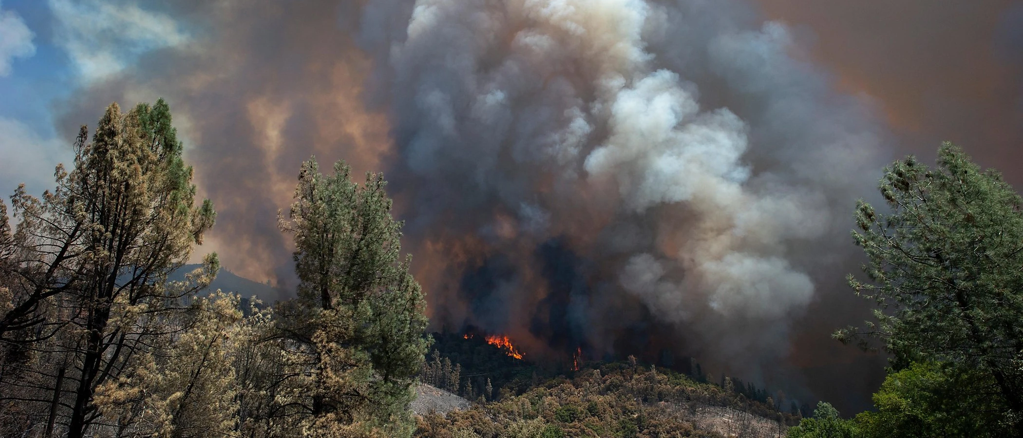
San Ramon's Wildfire Record
Understanding past fires helps predict future risk. Here are the most significant fire events near San Ramon.
118 acres burned along the Dublin-San Ramon border near Camp Parks training facility, east of Dougherty Road and Bollinger Canyon Road. Forward progress stopped same day with coordinated CAL FIRE, ACFD, and SRVFPD response.
The 393,624-acre SCU Lightning Complex Deer Zone affected Contra Costa County hills. San Ramon was on the fire perimeter edge and experienced evacuations and heavy smoke.
Local Risk Factors
Ridgeline WUI Exposure
Western ridgelines (Bollinger Canyon area) and southern boundary with Dublin (Dougherty Hills, Tassajara Valley) create extensive wildland-urban interface conditions.
Fast-Moving Grass Fires
Annual grassland on ridgelines and hillsides creates significant fuel loading. Dense grass growth in wet winters becomes fire fuel in summer. The 2025 Parks Fire demonstrated this risk.
Diablo Wind Corridor
Significant Diablo wind exposure from the east. Bollinger Canyon and Crow Canyon Road corridors channel winds, accelerating fire spread during Red Flag conditions.
Extensive Open Space
Bishop Ranch Regional Preserve, Las Trampas Regional Wilderness, Dougherty Hills Open Space, and Camp Parks training area create thousands of acres of adjacent wildland fuel.
Book a free on-site evaluation. We will design and install the right sprinkler and hardening system for your home.
Book Free EvaluationAll work performed by licensed and insured contractors.
Get the $149 assessment report. Find out what wildfire risk models flag on your property. Results in minutes.
Get $149 ReportSan Ramon Fire Environment
Vegetation Types
Wind Patterns
Significant Diablo wind exposure from the east; Bollinger Canyon and Crow Canyon wind corridors; multiple Red Flag Warnings per year
Topography
Tri-Valley location. Western ridgelines create WUI conditions. Eastern side transitions to Tassajara Valley agricultural and open space. Moderate to steep terrain on ridgelines.
Fire District
San Ramon Valley Fire Protection District
Insurance Impact
San Ramon hillside communities like Bollinger Canyon and Canyon Lakes can exceed $2M-$5M. Luxury hillside properties exceed the $3M FAIR Plan cap. SRVFPD's Class 1 ISO rating benefits structure insurance rates.
Protecting Your San Ramon Home & Family
Living in a fire-prone area means being proactive. Here are the steps every San Ramon homeowner should take to protect their property and prepare for wildfire season.
Evacuation Planning
Know your evacuation zone. SRVFPD has installed Evacuation Zone Signs throughout the community. Primary routes include I-680, Crow Canyon Road, Bollinger Canyon Road, and Dougherty Road. Register for Contra Costa County Community Warning System alerts.
Defensible Space
The SRVFPD Exterior Hazard Abatement program covers over 6,000 parcels and has been in place for over 20 years. Notices are issued annually with compliance enforcement. Take advantage of free Wildfire PEP workshops and courtesy inspections through SRVFPD.


Your Local Fire Safe Council
Diablo Firesafe Council
The Diablo Firesafe Council offers free resources, community chipping programs, home assessments, and education to help San Ramon residents reduce wildfire risk and prepare for fire season.
Visit Diablo Firesafe CouncilSan Ramon Wildfire Preparedness Resources
SRVFPD Exterior Hazard Abatement
Annual defensible space program serving 6,000+ parcels with compliance enforcement and free courtesy inspections.
SRVFPDDiablo Firesafe Council
Cost-share matching program for defensible space, community education, and regional wildfire planning.
Diablo Firesafe CouncilCAL FIRE Defensible Space Guide
Official California guide to creating defensible space zones around your property.
CAL FIREProtect Your San Ramon Home with FireRoofs
Defensible space and evacuation planning are essential, but they have limits. When embers are raining down and flames are approaching, your home needs both an automated active defense system and structural hardening that eliminates every ember entry point.
FireRoofs combines automated exterior sprinkler systems with structural home hardening for San Ramon properties. Our Detect → Alert → Defend system uses intelligent wildfire detection cameras, satellite monitoring, and high-pressure water to saturate your property. Our hardening scope seals every vulnerability embers exploit.
- Automated exterior sprinklers: roof and perimeter coverage with dual detection
- Ember-resistant vent retrofits to seal the attic from intrusion
- Noncombustible fencing to eliminate the fence-to-structure flame path
- Zone Zero landscape hardening within 5 feet of the structure
- Vegetation fire retardant application for surrounding landscape
- Class A firefighting foam add-on: 100% biodegradable, non-toxic, rinses off through sprinklers
- Insurance evidence packet documenting all upgrades, mapped to California Regulation 2644.9


Local Wildfire Resources for San Ramon Homeowners
Rules and requirements can change. Verify current requirements with your city or fire district before taking action.

Tree Removal and Defensible Space Rules
San Ramon follows city tree preservation ordinance with fire hazard exemptions. SRVFPD's Exterior Hazard Abatement program covers over 6,000 parcels in VHFHSZ. The district uses BurnBot remote masticator technology for fuel reduction since June 2025.
Fire Hazard Severity Zone: Very High and High FHSZ on western ridgelines and eastern Tassajara Valley transitions. Updated per 2025 CAL FIRE maps. Local Responsibility Area. SRVFPD uses XylaPlan modeling for fire pathway identification.

Free Programs for San Ramon Homeowners
- SRVFPD free Wildfire PEP (Preparedness Education Program) workshops
- SRVFPD free courtesy inspections through Community Risk Reduction Bureau
- Diablo Firesafe Council cost-share matching program for defensible space
- SRVFPD Exterior Hazard Abatement program (20+ year history)
Your Fire District
San Ramon Valley Fire Protection District (SRVFPD)
Community Designations
- Multiple Firewise USA neighborhoods
- Class 1 ISO rating (only ~1 in 19 CA agencies)
- Part of Contra Costa County CWPP
- Diablo Firesafe Council service area
Community designations like Firewise USA and Fire Risk Reduction Community may qualify homeowners for insurance benefits under California's Safer from Wildfires regulation.

Statewide Zone 0 Compliance Timeline
Board of Forestry rulemaking targeted for completion by December 31, 2025. New construction: compliance begins once rules are adopted (projected 2026). Existing structures: 3-year phase-in (compliance expected by approximately 2028-2029).
State Defensible Space (PRC 4291)
Zone 0: 0-5 feet, ember-resistant/noncombustible. Zone 1: 5-30 feet, lean, clean, and green. Zone 2: 30-100 feet, reduced fuel loading. Annual compliance inspections by local fire districts during fire season.
California Building Code
Effective 2026, California Wildland-Urban Interface Code (CWUIC) Part 7 replaces CBC Chapter 7A. Applies to new construction in designated fire hazard zones.
How FireRoofs Fits In
Understanding your local requirements is the first step. A FireRoofs automated defense system works alongside your defensible space, home hardening, and community efforts to give your home the strongest possible protection. During your free property evaluation, our team reviews your property in the context of San Ramon's specific requirements and helps you understand how active defense fits into your overall wildfire strategy.
Nearby Communities We Serve
FireRoofs also installs wildfire defense systems in neighboring communities with similar WUI risk profiles.
2026 Insurance Alert for San Ramon Homeowners
Homeowners in San Ramon are facing surging FAIR Plan rates and non-renewals from private carriers. California's Safer from Wildfires framework now requires participating insurers to offer discounts for documented mitigation systems. FireRoofs provides the engineering documentation and evidence packet designed to help you qualify for the voluntary market.
California's SB 429 (effective January 1, 2026) establishes the nation's first public wildfire catastrophe model, giving homeowners new tools to understand insurance risk scores. Ask HydroIQ what this means for San Ramon homeowners.
Request a Free Property EvaluationAsk HydroIQ About San Ramon - Free AI Wildfire Assistant
Get instant answers about San Ramon's wildfire risk level, defensible space requirements, fire history, FAIR Plan insurance options, and how exterior sprinkler systems can protect your home. HydroIQ covers communities across all nine Bay Area counties.
Protect Your San Ramon Property Today
Every San Ramon property is different. Get a free evaluation of your home's wildfire exposure and a custom defense plan.
Common Questions
What wildfire risk does San Ramon face?
San Ramon is designated a Very High Fire Hazard Severity Zone by CAL FIRE. Contra Costa County fire maps confirm extreme exposure driven by annual grassland and scattered oak woodland fuel loads and dry-season wind patterns. Western ridgelines (Bollinger Canyon area) and southern boundary with Dublin (Dougherty Hills, Tassajara Valley) create extensive wildland-urban interface conditions.
How does FireRoofs protect San Ramon homes from wildfire?
FireRoofs provides both active defense and passive home hardening for San Ramon properties. Active defense includes automated exterior sprinkler systems with dual detection, satellite monitoring, and intelligent fire detection cameras. Passive hardening covers ember-resistant vent retrofits, noncombustible fencing, Zone Zero landscape hardening, exterior cladding upgrades, and vegetation fire retardant. Every upgrade is documented in one evidence packet mapped to California Regulation 2644.9 for insurance recognition.
What does home hardening include for a San Ramon property?
Home hardening for San Ramon properties addresses every ember entry point on the structure. FireRoofs performs ember-resistant vent installation, noncombustible fencing replacement, eave and soffit sealing, Zone Zero landscape clearance within 5 feet of the structure, vegetation fire retardant application, and exterior cladding upgrades where needed. Scope is determined during a free property evaluation and accounts for site-specific conditions including lot size and exposure. All work is documented for insurance submission.
Where can I get instant answers about San Ramon's wildfire risk?
HydroIQ is FireRoofs' free wildfire assistant that provides instant, city-specific answers about San Ramon's fire hazard zone classification, defensible space requirements, local fire history, FAIR Plan insurance options, and wildfire defense systems. No sign-up required. Visit fireroofs.com/hydroiq to learn more or ask a question directly.
What is California home hardening?
California home hardening is the process of retrofitting a structure to resist wildfire ember intrusion and radiant heat exposure. It includes replacing combustible building materials, sealing openings such as attic vents and eaves, installing noncombustible fencing, clearing the Zone Zero perimeter within 5 feet of the structure, and applying fire-resistant treatments. Home hardening is one of the 12 mitigation categories under California Regulation 2644.9 (Safer from Wildfires) that participating insurers must recognize when setting premiums.
How do I get off the California FAIR Plan?
To transition from the California FAIR Plan back to the voluntary insurance market, homeowners need to demonstrate documented wildfire risk reduction. This includes property-level mitigation such as home hardening, automated exterior sprinkler systems, and defensible space maintenance. Under California Regulation 2644.9, admitted insurers are required to offer premium discounts for documented mitigation across 12 categories. FireRoofs provides the upgrades and the evidence packet that documents each improvement for your insurer or broker.
What are the 12 Safer from Wildfires mitigation categories?
California Regulation 2644.9 defines 12 mitigation categories that insurers must recognize: (1) Class A fire-rated roof, (2) Enclosed eaves, (3) Ember-resistant vents, (4) Exterior wall cladding, (5) Dual-pane or tempered windows, (6) Noncombustible fencing within 5 feet, (7) Defensible space Zone 0-2 maintained, (8) Community-level mitigation (Fire Risk Reduction Community), (9) Active fire defense system such as exterior sprinklers, (10) Fire-resistant landscaping, (11) Access and water supply, (12) Structure-specific risk reduction. FireRoofs addresses categories 1 through 10 directly.
Do exterior roof sprinklers qualify for insurance discounts in California?
Yes. Automated exterior sprinkler systems are recognized under Category 9 (Active Fire Defense System) of California Regulation 2644.9. When documented in an evidence packet and submitted to your insurer, they count toward the mitigation credits that admitted carriers are required to apply. FireRoofs installs dual-detection exterior sprinkler systems and provides the documentation package for insurance recognition. SB 429 (effective January 1, 2026) further supports this by establishing a public wildfire catastrophe model that factors documented improvements into risk scoring.
What is SRVFPD's Exterior Hazard Abatement program?
The Exterior Hazard Abatement program has been in place for over 20 years, covering 6,000+ parcels in VHFHSZ areas. Property owners receive annual notices with compliance requirements. SRVFPD also offers free courtesy inspections and Wildfire PEP workshops.
What is BurnBot and how is it used in San Ramon?
BurnBot is a remote masticator technology that SRVFPD has deployed since June 2025 for fuel reduction in critical fire passes. The contract runs up to $400,000 through August 2026, representing innovative wildfire mitigation technology.
What is SRVFPD's ISO rating?
SRVFPD holds a Class 1 ISO rating, awarded in 2021. Only approximately 1 in 19 California fire agencies achieve this top rating, which can benefit homeowner insurance rates.