Alamo Wildfire Defense
Alamo is an unincorporated community between Danville and Walnut Creek where luxury estates sit on multi-acre parcels at the base of Mount Diablo's western slope. The terrain is rolling hills and canyon country, with Las Trampas and Shell Ridge open spaces creating unbroken wildland fuel corridors from the mountain to the backyards of Alamo's most expensive homes. During the 2013 Morgan Fire on Mount Diablo, embers reached the Stone Valley and Green Valley neighborhoods. The 2020 SCU Complex approached from the east. What makes Alamo particularly vulnerable is that many homes were built in the 1960s and 70s before modern WUI building codes existed, with wood shake roofs, unscreened vents, and combustible siding still common.
$149 Wildfire Report for Alamo Homeowners
See what California wildfire codes require for your Alamo property. Covers roof, vents, defensible space, and insurance paperwork. Get your report in minutes.
CAL FIRE Risk Designation
Contra Costa County
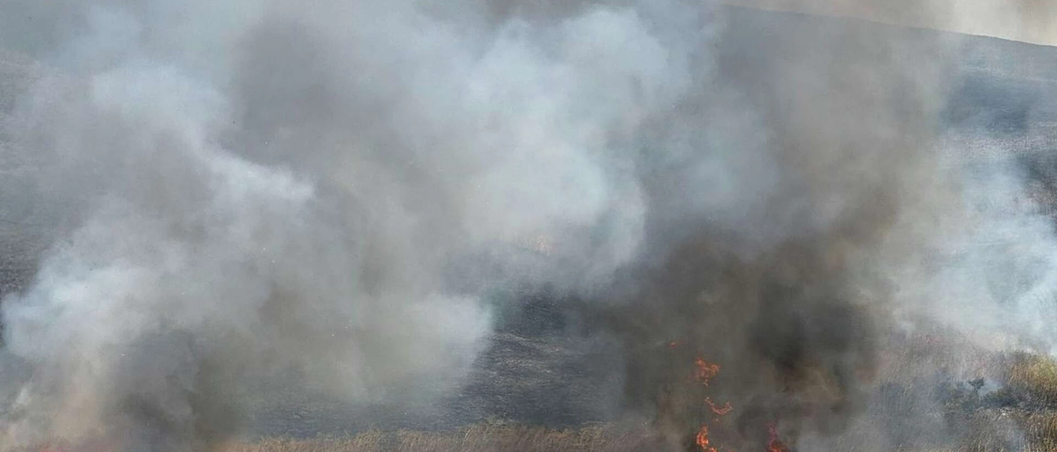
Alamo's luxury estates sit at the base of Mount Diablo, where fires have repeatedly sent embers into the Stone Valley and Green Valley neighborhoods.
FireRoofs Premier Home Hardening & Active Defense
FireRoofs provides premier wildfire defense and home hardening for Alamo properties. We combine automated exterior wildfire sprinkler systems with structural hardening that addresses every ember entry point on the home. Learn more about wildfire roof sprinkler installation and how it works alongside defensible space in Alamo.
Automated Exterior Sprinklers
Dual-detection roof and perimeter sprinklers with satellite monitoring
Ember-Resistant Vents
Retrofit vents that seal the attic from ember intrusion
Noncombustible Fencing
Eliminate the fence-to-structure flame path
Zone Zero Hardening
Clear combustible material within 5 feet of the structure
Vegetation Fire Retardant
Applied to surrounding landscape for ember resistance
Insurance Evidence Packet
Mapped to California Regulation 2644.9 for carrier submission
Alamo sits in the San Ramon Valley with direct exposure to Mount Diablo and the surrounding Diablo Range grasslands and oak woodland. Hot offshore Diablo winds regularly push fire from wildland toward Alamo residential areas, and the community has experienced multiple evacuations in recent decades. FireRoofs provides home hardening tailored to Alamo's unique combination of grassland fire risk and established residential construction.
Vulcan Vents Vent Retrofit for Alamo Homes
Alamo homes facing the Diablo Range receive some of the strongest ember exposure in Contra Costa County during fire events. Hot, dry winds accelerate embers directly into vent openings. Vulcan Vents replace vulnerable legacy vents with ASTM E2886-tested assemblies that combine stainless steel ember mesh with intumescent honeycomb technology, providing certified protection against both embers and direct flame impingement.
Vulcan Vents - California ComplianceMicro Mesh Gutter Guard Installation for Alamo Properties
Alamo properties at the base of Mount Diablo collect oak leaves, dry grass, and seed debris in gutters that become tinder-dry during summer and fall. When Diablo winds arrive, embers landing in these gutters ignite the roof edge immediately. Our noncombustible stainless steel micro mesh gutter guards eliminate gutter fuel loads, protecting one of the most commonly exploited ignition points on Alamo homes.
Fire Safe Marin - Fire-Resistant GuttersNon Combustible Fencing Installation in Alamo
Wood perimeter fencing throughout Alamo connects residential lots to each other and to wildland vegetation, creating fire pathways that bypass defensible space. Our noncombustible fencing installation replaces combustible wood sections within 5 feet of the structure with aluminum or steel panels that meet ASTM E136 noncombustibility standards. This addresses the AB 3074 Zone 0 requirement while maintaining the privacy Alamo homeowners value.
Ready for Wildfire - Defensible SpaceNoncombustible Landscape Fuelbreak for Alamo Homes
Alamo properties at the WUI edge often have bark mulch, dried ornamental grass, and dense plantings extending to the foundation. Our fuelbreak replaces combustible materials within the Zone 0 perimeter with noncombustible gravel, decomposed granite, or concrete hardscape. For Alamo properties exposed to fast-moving grass fires, eliminating this fuel pathway between landscape and structure is one of the most impactful hardening steps available.
Board of Forestry - Zone 0 StandardsDeck-to-Structure Ember Break for Alamo Properties
Alamo homes with large outdoor living areas often have wood decks directly attached to the house. Embers accumulate where decking meets siding, and dry grass debris packed into this joint ignites rapidly. Our ember break installs noncombustible flashing and hardscape separation at each deck-wall connection, interrupting the fire pathway at the point where the Safer from Wildfires framework requires noncombustible materials.
CA Dept of Insurance - Safer from WildfiresWhy Home Hardening Matters in Alamo
Alamo’s combination of unincorporated status, VHFHSZ designation, and estate-scale properties makes it a priority for comprehensive wildfire mitigation
FireRoofs provides the full scope: sprinklers, hardening, and documentation.

CAL FIRE Very High Fire Hazard Severity Zones (VHFHSZ) shown in red/orange
Source: CAL FIRE Fire Hazard Severity Zone data via Bay Area News Group
CAL FIRE VHFHSZ Designation
Very High FHSZ across much of Alamo, particularly in Mount Diablo foothill areas. Updated per 2025 CAL FIRE maps. State Responsibility Area on eastern Mount Diablo edges; Local Responsibility Area otherwise.
Alamo's Wildfire Record
Understanding past fires helps predict future risk. Here are the most significant fire events near Alamo.
The Deer Zone of the SCU Lightning Complex affected Contra Costa County hills adjacent to Alamo. Evacuations and heavy smoke impacts affected the community.
3,111 acres burned on Mount Diablo slopes bordering Alamo to the east. No structures in Alamo were destroyed, but proximity and smoke impacts were significant.
Local Risk Factors
Mount Diablo Adjacency
Mount Diablo rises directly to the east, creating significant wildland exposure. The 2013 Morgan Fire burned 3,111 acres on the mountain's slopes adjacent to Alamo.
Canyon Fire Pathways
Rolling hills and canyon terrain create multiple fire pathway opportunities from wildland into residential areas. Dense understory in canyons increases fuel loading.
Diablo Wind Acceleration
Mount Diablo creates its own wind patterns that accelerate fire behavior. Significant Diablo wind exposure during fall fire season with frequent Red Flag Warnings.
Large Estate Wildland Interface
Luxury estate properties on large parcels have extensive natural vegetation footprints and may face private-road access issues during evacuation.
Book a free on-site evaluation. We will design and install the right sprinkler and hardening system for your home.
Book Free EvaluationAll work performed by licensed and insured contractors.
Get the $149 assessment report. Find out what wildfire risk models flag on your property. Results in minutes.
Get $149 ReportAlamo Fire Environment
Vegetation Types
Wind Patterns
Significant Diablo wind exposure; Mount Diablo wind patterns accelerate fire behavior; frequent Red Flag Warnings during fall fire season
Topography
Rolling hills and canyon terrain between Danville and Walnut Creek. Mount Diablo rises to the east with foothills creating WUI conditions. Estate properties sit on varied terrain with significant wildland adjacency.
Fire District
San Ramon Valley Fire Protection District
Insurance Impact
Alamo is one of the wealthiest ZIP codes in the Bay Area with median home values $2.5M-$4M+ and luxury estates $5M-$20M+. Virtually every hillside and estate property exceeds the $3M FAIR Plan cap, creating significant underinsurance.
Protecting Your Alamo Home & Family
Living in a fire-prone area means being proactive. Here are the steps every Alamo homeowner should take to protect their property and prepare for wildfire season.
Evacuation Planning
Know routes to I-680, Danville Boulevard, Stone Valley Road, and Livorna Road. Eastern hillside and Mount Diablo-adjacent neighborhoods have limited egress. Estate properties on large parcels may have private-road access challenges. Register for Contra Costa County Community Warning System alerts.
Defensible Space
Luxury estate properties often require substantial defensible space work due to large natural vegetation footprints. SRVFPD conducts annual inspections and offers free Wildfire PEP workshops and courtesy inspections. The Exterior Hazard Abatement program provides compliance guidance.


Your Local Fire Safe Council
Diablo Firesafe Council
The Diablo Firesafe Council offers free resources, community chipping programs, home assessments, and education to help Alamo residents reduce wildfire risk and prepare for fire season.
Visit Diablo Firesafe CouncilAlamo Wildfire Preparedness Resources
SRVFPD Wildfire PEP Workshops
Free Wildfire Preparedness Education Program workshops and courtesy inspections from the Class 1 ISO-rated fire district.
SRVFPDDiablo Firesafe Council
Regional wildfire planning, cost-share programs, and community education resources.
Diablo Firesafe CouncilCAL FIRE Defensible Space Guide
Official California guide to creating defensible space zones around your property.
CAL FIREProtect Your Alamo Home with FireRoofs
Defensible space and evacuation planning are essential, but they have limits. When embers are raining down and flames are approaching, your home needs both an automated active defense system and structural hardening that eliminates every ember entry point.
FireRoofs combines automated exterior sprinkler systems with structural home hardening for Alamo properties. Our Detect → Alert → Defend system uses intelligent wildfire detection cameras, satellite monitoring, and high-pressure water to saturate your property. Our hardening scope seals every vulnerability embers exploit.
- Automated exterior sprinklers: roof and perimeter coverage with dual detection
- Ember-resistant vent retrofits to seal the attic from intrusion
- Noncombustible fencing to eliminate the fence-to-structure flame path
- Zone Zero landscape hardening within 5 feet of the structure
- Vegetation fire retardant application for surrounding landscape
- Class A firefighting foam add-on: 100% biodegradable, non-toxic, rinses off through sprinklers
- Insurance evidence packet documenting all upgrades, mapped to California Regulation 2644.9


Local Wildfire Resources for Alamo Homeowners
Rules and requirements can change. Verify current requirements with your city or fire district before taking action.

Tree Removal and Defensible Space Rules
Alamo follows Contra Costa County tree preservation ordinance. SRVFPD Exterior Hazard Abatement program applies with annual compliance requirements. Fire hazard exemptions available for defensible space work.
Fire Hazard Severity Zone: Very High FHSZ across much of Alamo, particularly in Mount Diablo foothill areas. State Responsibility Area on eastern Mount Diablo edges; Local Responsibility Area otherwise. Updated per 2025 CAL FIRE maps.

Free Programs for Alamo Homeowners
- SRVFPD Wildfire PEP workshops (free)
- SRVFPD free courtesy inspections
- Diablo Firesafe Council programs
- Contra Costa County Fire Safe Council resources
Your Fire District
San Ramon Valley Fire Protection District (SRVFPD)
Community Designations
- Firewise USA neighborhoods in hillside areas
- Diablo Firesafe Council service area
- Part of Contra Costa County CWPP
Community designations like Firewise USA and Fire Risk Reduction Community may qualify homeowners for insurance benefits under California's Safer from Wildfires regulation.

Statewide Zone 0 Compliance Timeline
Board of Forestry rulemaking targeted for completion by December 31, 2025. New construction: compliance begins once rules are adopted (projected 2026). Existing structures: 3-year phase-in (compliance expected by approximately 2028-2029).
State Defensible Space (PRC 4291)
Zone 0: 0-5 feet, ember-resistant/noncombustible. Zone 1: 5-30 feet, lean, clean, and green. Zone 2: 30-100 feet, reduced fuel loading. Annual compliance inspections by local fire districts during fire season.
California Building Code
Effective 2026, California Wildland-Urban Interface Code (CWUIC) Part 7 replaces CBC Chapter 7A. Applies to new construction in designated fire hazard zones.
How FireRoofs Fits In
Understanding your local requirements is the first step. A FireRoofs automated defense system works alongside your defensible space, home hardening, and community efforts to give your home the strongest possible protection. During your free property evaluation, our team reviews your property in the context of Alamo's specific requirements and helps you understand how active defense fits into your overall wildfire strategy.
Nearby Communities We Serve
FireRoofs also installs wildfire defense systems in neighboring communities with similar WUI risk profiles.
2026 Insurance Alert for Alamo Homeowners
Homeowners in Alamo are facing surging FAIR Plan rates and non-renewals from private carriers. California's Safer from Wildfires framework now requires participating insurers to offer discounts for documented mitigation systems. FireRoofs provides the engineering documentation and evidence packet designed to help you qualify for the voluntary market.
California's SB 429 (effective January 1, 2026) establishes the nation's first public wildfire catastrophe model, giving homeowners new tools to understand insurance risk scores. Ask HydroIQ what this means for Alamo homeowners.
Request a Free Property EvaluationAsk HydroIQ About Alamo - Free AI Wildfire Assistant
Get instant answers about Alamo's wildfire risk level, defensible space requirements, fire history, FAIR Plan insurance options, and how exterior sprinkler systems can protect your home. HydroIQ covers communities across all nine Bay Area counties.
Protect Your Alamo Property Today
Every Alamo property is different. Get a free evaluation of your home's wildfire exposure and a custom defense plan.
Common Questions
What wildfire risk does Alamo face?
Alamo is designated a Very High Fire Hazard Severity Zone by CAL FIRE. Contra Costa County fire maps confirm extreme exposure driven by annual grassland and valley oak woodland fuel loads and dry-season wind patterns. Mount Diablo rises directly to the east, creating significant wildland exposure. The 2013 Morgan Fire burned 3,111 acres on the mountain's slopes adjacent to Alamo.
How does FireRoofs protect Alamo homes from wildfire?
FireRoofs provides both active defense and passive home hardening for Alamo properties. Active defense includes automated exterior sprinkler systems with dual detection, satellite monitoring, and intelligent fire detection cameras. Passive hardening covers ember-resistant vent retrofits, noncombustible fencing, Zone Zero landscape hardening, exterior cladding upgrades, and vegetation fire retardant. Every upgrade is documented in one evidence packet mapped to California Regulation 2644.9 for insurance recognition.
What does home hardening include for a Alamo property?
Home hardening for Alamo properties addresses every ember entry point on the structure. FireRoofs performs ember-resistant vent installation, noncombustible fencing replacement, eave and soffit sealing, Zone Zero landscape clearance within 5 feet of the structure, vegetation fire retardant application, and exterior cladding upgrades where needed. Scope is determined during a free property evaluation and accounts for site-specific conditions including lot size and exposure. All work is documented for insurance submission.
Where can I get instant answers about Alamo's wildfire risk?
HydroIQ is FireRoofs' free wildfire assistant that provides instant, city-specific answers about Alamo's fire hazard zone classification, defensible space requirements, local fire history, FAIR Plan insurance options, and wildfire defense systems. No sign-up required. Visit fireroofs.com/hydroiq to learn more or ask a question directly.
What is California home hardening?
California home hardening is the process of retrofitting a structure to resist wildfire ember intrusion and radiant heat exposure. It includes replacing combustible building materials, sealing openings such as attic vents and eaves, installing noncombustible fencing, clearing the Zone Zero perimeter within 5 feet of the structure, and applying fire-resistant treatments. Home hardening is one of the 12 mitigation categories under California Regulation 2644.9 (Safer from Wildfires) that participating insurers must recognize when setting premiums.
How do I get off the California FAIR Plan?
To transition from the California FAIR Plan back to the voluntary insurance market, homeowners need to demonstrate documented wildfire risk reduction. This includes property-level mitigation such as home hardening, automated exterior sprinkler systems, and defensible space maintenance. Under California Regulation 2644.9, admitted insurers are required to offer premium discounts for documented mitigation across 12 categories. FireRoofs provides the upgrades and the evidence packet that documents each improvement for your insurer or broker.
What are the 12 Safer from Wildfires mitigation categories?
California Regulation 2644.9 defines 12 mitigation categories that insurers must recognize: (1) Class A fire-rated roof, (2) Enclosed eaves, (3) Ember-resistant vents, (4) Exterior wall cladding, (5) Dual-pane or tempered windows, (6) Noncombustible fencing within 5 feet, (7) Defensible space Zone 0-2 maintained, (8) Community-level mitigation (Fire Risk Reduction Community), (9) Active fire defense system such as exterior sprinklers, (10) Fire-resistant landscaping, (11) Access and water supply, (12) Structure-specific risk reduction. FireRoofs addresses categories 1 through 10 directly.
Do exterior roof sprinklers qualify for insurance discounts in California?
Yes. Automated exterior sprinkler systems are recognized under Category 9 (Active Fire Defense System) of California Regulation 2644.9. When documented in an evidence packet and submitted to your insurer, they count toward the mitigation credits that admitted carriers are required to apply. FireRoofs installs dual-detection exterior sprinkler systems and provides the documentation package for insurance recognition. SB 429 (effective January 1, 2026) further supports this by establishing a public wildfire catastrophe model that factors documented improvements into risk scoring.
How does Mount Diablo affect Alamo's fire risk?
Mount Diablo rises directly to the east of Alamo, creating significant wildland exposure. The 2013 Morgan Fire burned 3,111 acres on the mountain's slopes adjacent to Alamo. Mount Diablo also creates its own wind patterns that accelerate fire behavior in adjacent communities.
What fire district serves Alamo?
SRVFPD serves Alamo along with San Ramon, Danville, Blackhawk, and Diablo. The district holds a Class 1 ISO rating and operates extensive wildfire mitigation programs including BurnBot technology and the Exterior Hazard Abatement program.
Are there free programs for Alamo homeowners?
Yes. SRVFPD offers free Wildfire PEP workshops and courtesy inspections. The Diablo Firesafe Council provides cost-share programs and community education resources.