Emerald Hills Wildfire Defense
Emerald Hills is an unincorporated pocket of San Mateo County that sits on a steep, west-facing ridge above Redwood City. The community of roughly 4,500 people occupies terrain that was built for views, not fire safety. Homes along Jefferson Avenue and Lakeview Way perch on narrow lots carved into hillsides covered with native oak, madrone, and non-native broom and eucalyptus. The 2022 Edgewood Fire started less than a mile from Emerald Hills and was contained only because wind conditions were favorable. Fire officials have stated publicly that the same ignition under Diablo wind conditions would have been catastrophic for this community.
$149 Wildfire Report for Emerald Hills Homeowners
See what California wildfire codes require for your Emerald Hills property. Covers roof, vents, defensible space, and insurance paperwork. Get your report in minutes.
of Emerald Hills properties within VHFHSZ zones
San Mateo County
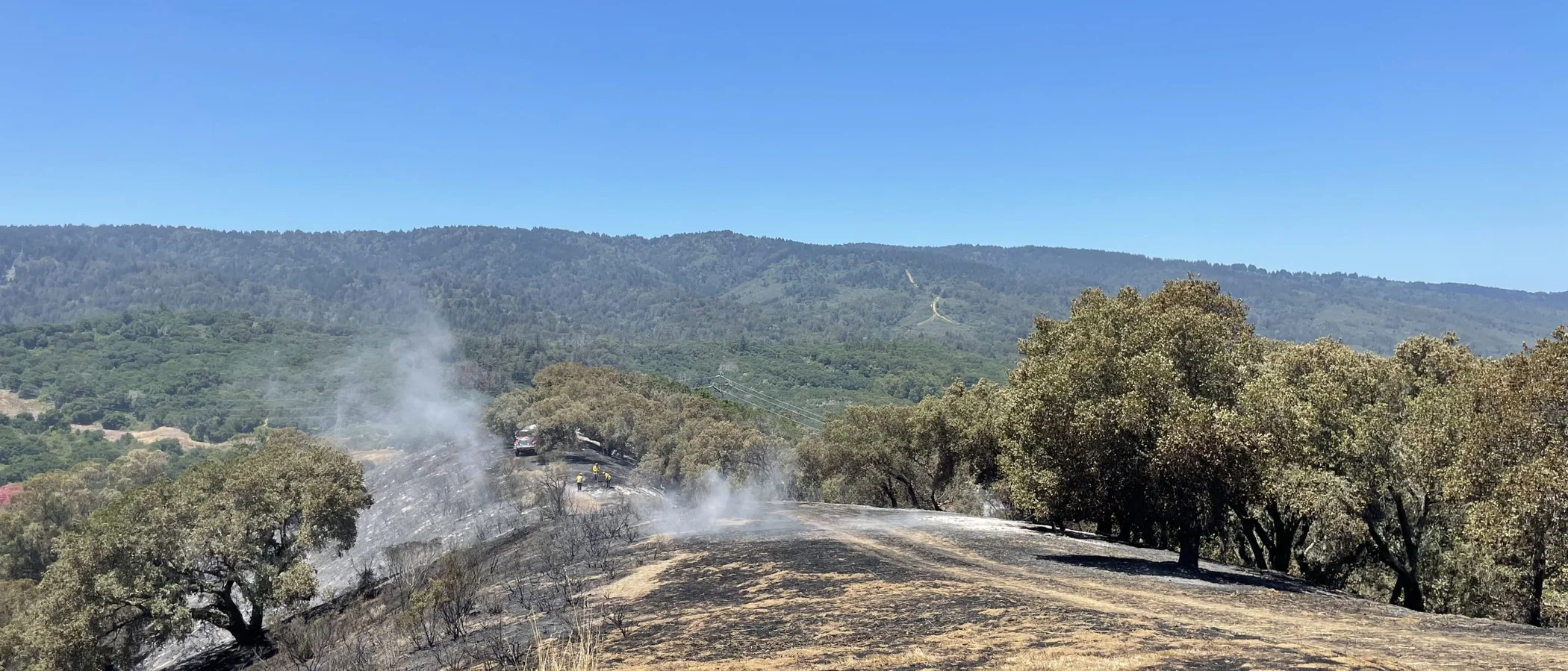
Emerald Hills sits on a steep ridge above Redwood City where the 2022 Edgewood Fire started less than a mile from the community.
FireRoofs Premier Home Hardening & Active Defense
FireRoofs provides premier wildfire defense and home hardening for Emerald Hills properties. We combine automated exterior sprinkler systems with structural hardening that addresses every ember entry point on the home.
Automated Exterior Sprinklers
Dual-detection roof and perimeter sprinklers with satellite monitoring
Ember-Resistant Vents
Retrofit vents that seal the attic from ember intrusion
Noncombustible Fencing
Eliminate the fence-to-structure flame path
Zone Zero Hardening
Clear combustible material within 5 feet of the structure
Vegetation Fire Retardant
Applied to surrounding landscape for ember resistance
Insurance Evidence Packet
Mapped to California Regulation 2644.9 for carrier submission
Emerald Hills straddles the boundary between Redwood City and unincorporated San Mateo County, with homes scattered across wooded ridges overlooking the Bay. Properties along upper and lower Emerald Hills Road face direct exposure to wildland fire from the adjacent open space preserves. The area's steep slopes and heavy live oak canopy create conditions where comprehensive home hardening is essential.
EmberSafe Gutter Guard Installation in Emerald Hills
Emerald Hills properties under live oak and bay laurel canopy face year-round debris accumulation in gutters. During Diablo wind events, embers can travel from open space preserves directly into residential areas, igniting debris-laden gutters on first contact. Our stainless steel micro mesh guards keep gutters clean and noncombustible, a priority recommendation from the Fire Safe San Mateo County home hardening program.
Fire Safe San Mateo - Home HardeningVulcan Vents Vent Retrofit for Emerald Hills Homes
Homes along the ridge in Emerald Hills are particularly exposed to wind-driven embers from downslope fires. Standard vents with 1/4-inch or even 1/8-inch mesh allow embers to enter attics and crawl spaces. Vulcan Vents are California State Fire Marshal-listed and ASTM E2886-certified, providing the ember and flame resistance that Emerald Hills ridgeline properties demand under current WUI building standards.
Fire Safe San Mateo - Vent HardeningUnder Deck Enclosure for Emerald Hills Ridge Homes
Ridge-top homes in Emerald Hills often have elevated decks taking advantage of Bay views, leaving exposed spaces underneath that trap wind-deposited debris. Our under deck enclosure uses noncombustible metal mesh or fiber-cement panels to close off this space. The installation meets Fire Safe San Mateo recommendations for deck fire protection while maintaining adequate ventilation to protect structural members from moisture damage.
Fire Safe Marin - Deck Fire ProtectionNon Combustible Deck Retrofit in Emerald Hills
Older Emerald Hills homes frequently have original wood decking that is weathered and dried, making it highly susceptible to ember ignition. Our retrofit replaces combustible deck surfaces with fire-tested materials listed on the State Fire Marshal BML database. The SFM 12-7A-4 test subjects materials to sustained under-deck flame exposure, ensuring the replacement decking resists the conditions Emerald Hills homes face during a wildfire.
Fire Safe San Mateo - Deck ProtectionOpen Eave Enclosure for Emerald Hills Properties
Mid-century homes in Emerald Hills commonly feature open eave construction with exposed rafter tails. This design creates direct pathways for embers to enter the attic. Our retrofit encloses eaves with noncombustible soffit material and installs WUI-rated vents that meet the ASTM E2886 standard, bringing existing construction up to the Chapter 7A requirements that now apply to all new construction in San Mateo County fire hazard zones.
CALBO - WUI Building Code ChangesWhy Home Hardening Matters in Emerald Hills
With the Edgewood Fire as a recent reminder, Emerald Hills homeowners know the threat is real and nearby
FireRoofs provides the complete defense package: automated sprinklers, full-spectrum hardening, and the documentation that gives your insurer what they need.

CAL FIRE Very High Fire Hazard Severity Zones (VHFHSZ) shown in red/orange
Source: CAL FIRE Fire Hazard Severity Zone data via Bay Area News Group
CAL FIRE VHFHSZ Designation
Emerald Hills is designated as a Very High Fire Hazard Severity Zone by CAL FIRE. The designation covers the majority of the community due to its hillside location, dense vegetation, and proximity to wildland areas.
Emerald Hills's Wildfire Record
Understanding past fires helps predict future risk. Here are the most significant fire events near Emerald Hills.
A small but fast-moving grass fire near Woodside prompted evacuation warnings for adjacent Emerald Hills neighborhoods.
Burned over 700 acres in the nearby Kings Mountain area, demonstrating the fire risk to Peninsula hillside communities.
Local Risk Factors
Ridge-Top Wind Exposure
Emerald Hills sits atop the Peninsula ridge where offshore winds accelerate and funnel through canyons, driving rapid fire spread.
Dense Vegetation
Oak woodland, chaparral, and thick brush extend into residential neighborhoods with homes built directly into the hillside vegetation.
Steep Terrain
Hillside lots with significant slope create fire chimneys and make suppression operations challenging.
Narrow Winding Roads
Many Emerald Hills streets are narrow, winding, and steep, complicating evacuation and fire engine access.
Book a free on-site evaluation. We will design and install the right sprinkler and hardening system for your home.
Book Free EvaluationGet the $149 assessment report. Find out what wildfire risk models flag on your property. Results in minutes.
Get $149 ReportEmerald Hills Fire Environment
Vegetation Types
Wind Patterns
Strong offshore (Diablo-type) winds in fall; fog-driven marine layer provides summer moisture
Topography
Elevation ranges from 400 ft to 900 ft. Steep west and east-facing slopes with narrow ridgeline development.
Fire District
Woodside Fire Protection District
Insurance Impact
Emerald Hills properties face growing insurance challenges due to VHFHSZ designation. Non-renewals have increased, and many homeowners are transitioning to the FAIR Plan.
Protecting Your Emerald Hills Home & Family
Living in a fire-prone area means being proactive. Here are the steps every Emerald Hills homeowner should take to protect their property and prepare for wildfire season.
Evacuation Planning
Register for SMC Alert and download Genasys Protect. Know at least two routes off the hill. Do not wait for official orders during a fast-moving fire event.
Defensible Space
Maintain aggressive defensible space on all sides of your home. Hillside lots need special attention to downslope vegetation. FIRE SAFE San Mateo County offers a free chipper program to help with vegetation disposal.


Your Local Fire Safe Council
FIRE SAFE San Mateo County
The FIRE SAFE San Mateo County offers free resources, community chipping programs, home assessments, and education to help Emerald Hills residents reduce wildfire risk and prepare for fire season.
Visit FIRE SAFE San Mateo CountyEmerald Hills Wildfire Preparedness Resources
FIRE SAFE San Mateo County
Free chipper program, home hardening guides, fire-safe landscaping information.
Fire Safe San MateoSan Mateo County Fire Hazard Zones
Official San Mateo County fire hazard maps and building code requirements.
San Mateo CountyCAL FIRE Defensible Space Guide
Official California guide to creating defensible space zones around your property.
CAL FIREProtect Your Emerald Hills Home with FireRoofs
Defensible space and evacuation planning are essential, but they have limits. When embers are raining down and flames are approaching, your home needs both an automated active defense system and structural hardening that eliminates every ember entry point.
FireRoofs combines automated exterior sprinkler systems with structural home hardening for Emerald Hills properties. Our Detect → Alert → Defend system uses intelligent wildfire detection cameras, satellite monitoring, and high-pressure water to saturate your property. Our hardening scope seals every vulnerability embers exploit.
- Automated exterior sprinklers: roof and perimeter coverage with dual detection
- Ember-resistant vent retrofits to seal the attic from intrusion
- Noncombustible fencing to eliminate the fence-to-structure flame path
- Zone Zero landscape hardening within 5 feet of the structure
- Vegetation fire retardant application for surrounding landscape
- Class A firefighting foam add-on: 100% biodegradable, non-toxic, rinses off through sprinklers
- Insurance evidence packet documenting all upgrades, mapped to California Regulation 2644.9


Local Wildfire Resources for Emerald Hills Homeowners
Rules and requirements can change. Verify current requirements with your city or fire district before taking action.

Tree Removal and Defensible Space Rules
County of San Mateo permits for native trees over 10 inches diameter. Exemptions for defensible space within 30 feet. WFPD Ordinance 24-01 applies with annual inspections.
Fire Hazard Severity Zone: Very High (85-95%). Local Responsibility Area.

Free Programs for Emerald Hills Homeowners
- WFPD free chipper program (May through November for VHFHSZ residents)
Your Fire District
Woodside Fire Protection District (WFPD)
Community Designations
- Firewise USA recognized sites in Emerald Hills
Community designations like Firewise USA and Fire Risk Reduction Community may qualify homeowners for insurance benefits under California's Safer from Wildfires regulation.

Statewide Zone 0 Compliance Timeline
Board of Forestry rulemaking targeted for completion by December 31, 2025. New construction: compliance begins once rules are adopted (projected 2026). Existing structures: 3-year phase-in (compliance expected by approximately 2028-2029).
State Defensible Space (PRC 4291)
Zone 0: 0-5 feet, ember-resistant/noncombustible. Zone 1: 5-30 feet, lean, clean, and green. Zone 2: 30-100 feet, reduced fuel loading. Annual compliance inspections by local fire districts during fire season.
California Building Code
Effective 2026, California Wildland-Urban Interface Code (CWUIC) Part 7 replaces CBC Chapter 7A. Applies to new construction in designated fire hazard zones.
How FireRoofs Fits In
Understanding your local requirements is the first step. A FireRoofs automated defense system works alongside your defensible space, home hardening, and community efforts to give your home the strongest possible protection. During your free property evaluation, our team reviews your property in the context of Emerald Hills's specific requirements and helps you understand how active defense fits into your overall wildfire strategy.
Nearby Communities We Serve
FireRoofs also installs wildfire defense systems in neighboring communities with similar WUI risk profiles.
2026 Insurance Alert for Emerald Hills Homeowners
Homeowners in Emerald Hills are facing surging FAIR Plan rates and non-renewals from private carriers. California's Safer from Wildfires framework now requires participating insurers to offer discounts for documented mitigation systems. FireRoofs provides the engineering documentation and evidence packet designed to help you qualify for the voluntary market.
California's SB 429 (effective January 1, 2026) establishes the nation's first public wildfire catastrophe model, giving homeowners new tools to understand insurance risk scores. Ask HydroIQ what this means for Emerald Hills homeowners.
Request a Free Property EvaluationAsk HydroIQ About Emerald Hills - Free AI Wildfire Assistant
Get instant answers about Emerald Hills's wildfire risk level, defensible space requirements, fire history, FAIR Plan insurance options, and how exterior sprinkler systems can protect your home. HydroIQ covers communities across all nine Bay Area counties.
Protect Your Emerald Hills Property Today
Every Emerald Hills property is different. Get a free evaluation of your home's wildfire exposure and a custom defense plan.
Common Questions
What wildfire risk does Emerald Hills face?
Emerald Hills is designated a Very High Fire Hazard Severity Zone by CAL FIRE. San Mateo County fire maps confirm extreme exposure driven by coast live oak woodland and chaparral fuel loads and seasonal offshore winds. Emerald Hills sits atop the Peninsula ridge where offshore winds accelerate and funnel through canyons, driving rapid fire spread.
How does FireRoofs protect Emerald Hills homes from wildfire?
FireRoofs provides both active defense and passive home hardening for Emerald Hills properties. Active defense includes automated exterior sprinkler systems with dual detection, satellite monitoring, and intelligent fire detection cameras. Passive hardening covers ember-resistant vent retrofits, noncombustible fencing, Zone Zero landscape hardening, exterior cladding upgrades, and vegetation fire retardant. Every upgrade is documented in one evidence packet mapped to California Regulation 2644.9 for insurance recognition.
What does home hardening include for a Emerald Hills property?
Home hardening for Emerald Hills properties addresses every ember entry point on the structure. FireRoofs performs ember-resistant vent installation, noncombustible fencing replacement, eave and soffit sealing, Zone Zero landscape clearance within 5 feet of the structure, vegetation fire retardant application, and exterior cladding upgrades where needed. Scope is determined during a free property evaluation and accounts for local terrain and elevation changes. All work is documented for insurance submission.
Where can I get instant answers about Emerald Hills's wildfire risk?
HydroIQ is FireRoofs' free wildfire assistant that provides instant, city-specific answers about Emerald Hills's fire hazard zone classification, defensible space requirements, local fire history, FAIR Plan insurance options, and wildfire defense systems. No sign-up required. Visit fireroofs.com/hydroiq to learn more or ask a question directly.
What is California home hardening?
California home hardening is the process of retrofitting a structure to resist wildfire ember intrusion and radiant heat exposure. It includes replacing combustible building materials, sealing openings such as attic vents and eaves, installing noncombustible fencing, clearing the Zone Zero perimeter within 5 feet of the structure, and applying fire-resistant treatments. Home hardening is one of the 12 mitigation categories under California Regulation 2644.9 (Safer from Wildfires) that participating insurers must recognize when setting premiums.
How do I get off the California FAIR Plan?
To transition from the California FAIR Plan back to the voluntary insurance market, homeowners need to demonstrate documented wildfire risk reduction. This includes property-level mitigation such as home hardening, automated exterior sprinkler systems, and defensible space maintenance. Under California Regulation 2644.9, admitted insurers are required to offer premium discounts for documented mitigation across 12 categories. FireRoofs provides the upgrades and the evidence packet that documents each improvement for your insurer or broker.
What are the 12 Safer from Wildfires mitigation categories?
California Regulation 2644.9 defines 12 mitigation categories that insurers must recognize: (1) Class A fire-rated roof, (2) Enclosed eaves, (3) Ember-resistant vents, (4) Exterior wall cladding, (5) Dual-pane or tempered windows, (6) Noncombustible fencing within 5 feet, (7) Defensible space Zone 0-2 maintained, (8) Community-level mitigation (Fire Risk Reduction Community), (9) Active fire defense system such as exterior sprinklers, (10) Fire-resistant landscaping, (11) Access and water supply, (12) Structure-specific risk reduction. FireRoofs addresses categories 1 through 10 directly.
Do exterior roof sprinklers qualify for insurance discounts in California?
Yes. Automated exterior sprinkler systems are recognized under Category 9 (Active Fire Defense System) of California Regulation 2644.9. When documented in an evidence packet and submitted to your insurer, they count toward the mitigation credits that admitted carriers are required to apply. FireRoofs installs dual-detection exterior sprinkler systems and provides the documentation package for insurance recognition. SB 429 (effective January 1, 2026) further supports this by establishing a public wildfire catastrophe model that factors documented improvements into risk scoring.
What defensible space rules apply in Emerald Hills?
WFPD Ordinance 24-01 mandates fuel mitigation with annual inspections in VHFHSZ areas. San Mateo County requires permits for native trees over 10 inches diameter, with exemptions for defensible space within 30 feet of structures.
Are there free wildfire programs for Emerald Hills residents?
Yes. The Woodside Fire Protection District offers a free chipper program from May through November for VHFHSZ residents. Emerald Hills has Firewise USA recognized communities.