Santa Cruz Wildfire Defense
Santa Cruz learned its wildfire lesson the hard way in August 2020 when the CZU Lightning Complex fire burned 86,509 acres, destroyed 1,490 structures, and forced the evacuation of 77,000 people across Santa Cruz and San Mateo counties. Homes on the UCSC campus, along Empire Grade, and in Bonny Doon burned completely. The fire reached the edge of the city of Santa Cruz itself, stopped only by a combination of marine air and an all-hands firefighting effort. The lesson: being on the coast does not protect you. When offshore winds override the marine layer, the dense redwood and mixed-conifer forest surrounding Santa Cruz burns like any other mountain community.
$149 Wildfire Report for Santa Cruz Homeowners
See what California wildfire codes require for your Santa Cruz property. Covers roof, vents, defensible space, and insurance paperwork. Get your report in minutes.
CAL FIRE Risk Designation
Santa Cruz County
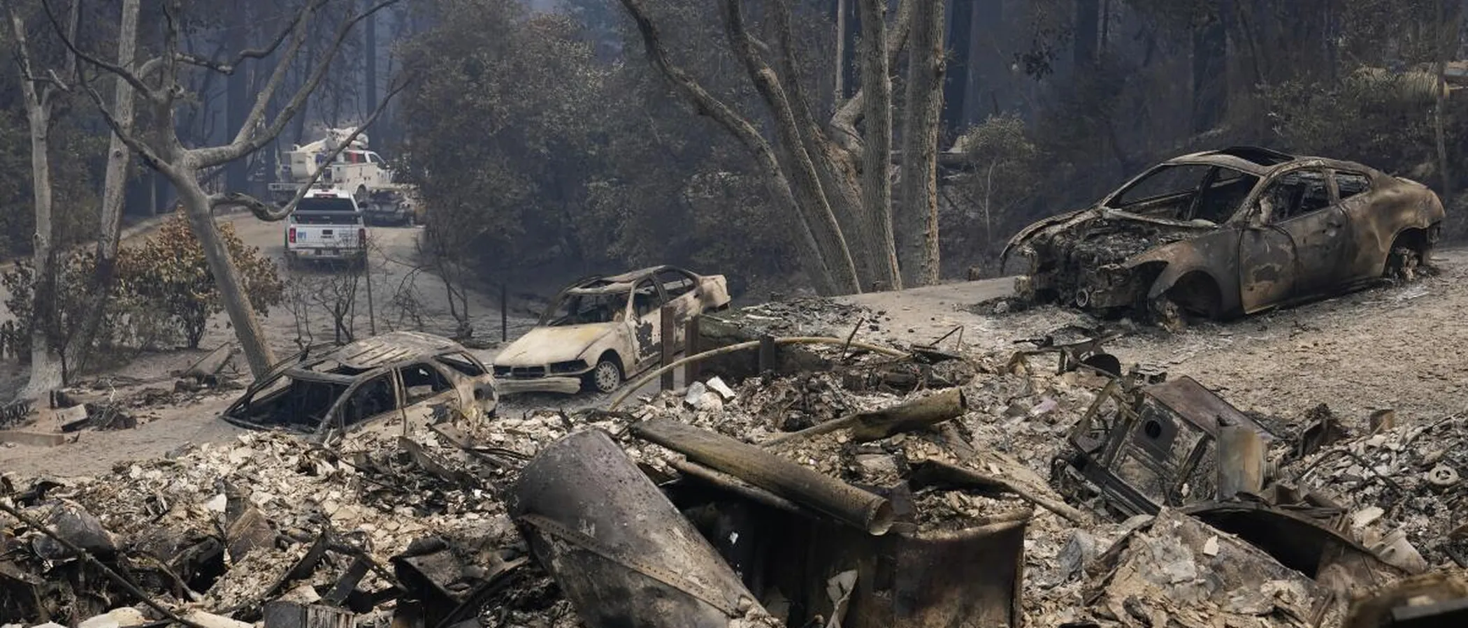
The 2020 CZU Lightning Complex fire destroyed 1,490 structures in Santa Cruz County and forced the evacuation of 77,000 residents.
FireRoofs Premier Home Hardening & Active Defense
FireRoofs provides premier wildfire defense and home hardening for Santa Cruz properties. We combine automated exterior sprinkler systems with structural hardening that addresses every ember entry point on the home.
Automated Exterior Sprinklers
Dual-detection roof and perimeter sprinklers with satellite monitoring
Ember-Resistant Vents
Retrofit vents that seal the attic from ember intrusion
Noncombustible Fencing
Eliminate the fence-to-structure flame path
Zone Zero Hardening
Clear combustible material within 5 feet of the structure
Vegetation Fire Retardant
Applied to surrounding landscape for ember resistance
Insurance Evidence Packet
Mapped to California Regulation 2644.9 for carrier submission
Santa Cruz extends from the coast to the forested ridges above the city, with neighborhoods in the UCSC campus area and upper Westside facing significant wildfire exposure. The 2020 CZU Lightning Complex forced evacuations across Santa Cruz County, demonstrating how quickly mountain fires can threaten urban areas. FireRoofs provides comprehensive hardening for Santa Cruz homes where the city meets the wildland.
EmberSafe Gutter Guard Installation in Santa Cruz
Santa Cruz homes in the hills and near UCSC sit under mixed redwood and oak canopy that deposits constant debris in gutters. During the CZU fire, ember showers reached well into developed areas. Our stainless steel micro mesh gutter guards block debris accumulation while resisting the salt air corrosion common in Santa Cruz. Noncombustible gutter covers are a top-priority hardening measure for any Santa Cruz home in or near fire hazard zones.
Fire Safe Marin - Gutter ProtectionVulcan Vents Vent Retrofit for Santa Cruz Wildfire Defense
Santa Cruz homes built before WUI codes were adopted commonly have vents with mesh openings that allow embers direct access to attics. The CZU fire showed that Santa Cruz is not immune to wildfire, and vent hardening is one of the most cost-effective upgrades available. Vulcan Vents with ASTM E2886 testing and California State Fire Marshal approval provide the highest level of ember and flame resistance for Santa Cruz vent openings.
Vulcan Vents - Code Compliance GuideNon Combustible Fencing for Santa Cruz Properties
Wood fencing is widespread in Santa Cruz neighborhoods and creates continuous combustible pathways between properties. During a wildfire, fence fires can spread from lot to lot faster than firefighters can respond. Our noncombustible fencing installation replaces wood fence sections within 5 feet of the structure with steel or aluminum alternatives, meeting AB 3074 Zone 0 requirements and cutting the primary fire transfer route between neighboring properties.
Ready for Wildfire - Defensible Space GuideOpen Eave Enclosure for Santa Cruz Homes
Many Santa Cruz homes, especially in the hills and older neighborhoods, have open eave construction that exposes rafter tails and provides ember entry into the attic. Our enclosure retrofit boxes in open eaves with noncombustible soffit material and integrates WUI-compliant vents meeting ASTM E2886 standards. This brings older Santa Cruz construction into alignment with current Chapter 7A requirements while preserving the home's architectural character.
CALBO - Chapter 7A Building CodeDeck-to-Structure Ember Break in Santa Cruz
Santa Cruz homes with wood decks attached to the structure have a concentrated ignition vulnerability where decking meets siding. Redwood needles and debris pack into this joint and ignite from a single ember. Our ember break installs noncombustible flashing and a hardscape separation at each deck-wall connection, preventing the dual-surface ignition that the California Safer from Wildfires framework identifies as a critical mitigation target.
CA Dept of Insurance - Safer from WildfiresWhy Home Hardening Matters in Santa Cruz
The CZU fire proved what fire scientists already knew: homes in the Santa Cruz Mountains need to survive on their own. Fire crews cannot reach every property. Evacuation routes get cut off. The homes that survive are the ones with hardened structures and active defense systems
FireRoofs was founded in this terrain. We design Fortress-tier systems with Class A foam, tank failover, and satellite communication for mountain properties. The hardening scope covers every mitigation category relevant to mountain homes: vents, eaves, fencing, cladding, Zone Zero, and defensible space out to 100 feet. The evidence packet is comprehensive and carrier-ready.

CAL FIRE Very High Fire Hazard Severity Zones (VHFHSZ) shown in red/orange
Source: CAL FIRE Fire Hazard Severity Zone data via Bay Area News Group
CAL FIRE VHFHSZ Designation
Portions of Santa Cruz and its surrounding areas fall within VHFHSZ designations by CAL FIRE, particularly in the northern and western hills extending into the Santa Cruz Mountains.
Santa Cruz's Wildfire Record
Understanding past fires helps predict future risk. Here are the most significant fire events near Santa Cruz.
Burned 86,509 acres in the Santa Cruz Mountains, destroying nearly 1,000 structures including 697 single-family homes. Over 77,000 people evacuated across Santa Cruz and San Mateo counties.
Burned 7,817 acres north of Santa Cruz near Bonny Doon, triggering evacuations in the Bonny Doon and Swanton areas.
Burned 4,270 acres and destroyed 132 structures near Summit Road in the Santa Cruz Mountains, sending smoke across the city for weeks.
Local Risk Factors
Mountain-to-Coast Fire Corridor
Santa Cruz Mountains fires can run downslope toward the city, driven by offshore winds and steep terrain. The CZU fire burned within miles of urban Santa Cruz before containment lines held.
Dense Redwood-Chaparral Mix
The forest canopy surrounding Santa Cruz creates extreme fuel loads. Drought-stressed redwoods and understory vegetation burn intensely when conditions align.
WUI Development Pattern
Santa Cruz County has extensive WUI areas where residential development extends into fire-prone wildlands, placing a significant number of homes in the fire zone.
Post-Fire Debris Flow Risk
Burned hillsides above Santa Cruz create dangerous debris flow conditions during winter rains, compounding wildfire damage with mudslide risk.
Book a free on-site evaluation. We will design and install the right sprinkler and hardening system for your home.
Book Free EvaluationGet the $149 assessment report. Find out what wildfire risk models flag on your property. Results in minutes.
Get $149 ReportSanta Cruz Fire Environment
Vegetation Types
Wind Patterns
Offshore winds (NE) in fall drive fire downslope; marine layer provides summer moisture but vanishes during heat events
Topography
Elevation ranges from sea level to 2,600 ft in the mountains. Steep east and south-facing slopes channel fire toward developed areas.
Fire District
Santa Cruz Fire Department, Station 1
Insurance Impact
After the CZU fire, insurance non-renewals in Santa Cruz County surged. Many mountain and foothill homeowners have been pushed to the FAIR Plan, with some unable to find coverage at any price.
Protecting Your Santa Cruz Home & Family
Living in a fire-prone area means being proactive. Here are the steps every Santa Cruz homeowner should take to protect their property and prepare for wildfire season.
Evacuation Planning
Santa Cruz has limited evacuation routes. Highway 1 and Highway 17 are the main arteries. During the CZU fire, over 77,000 people evacuated and traffic gridlocked. Register for CruzAlert, know your zone, and leave at the first warning. Don't wait for a mandatory order.
Defensible Space
The Fire Safe Council of Santa Cruz County offers free chipping programs and vegetation management assistance. Create 100 feet of defensible space, focusing on removing dead material from under redwood trees and clearing brush from around structures.


Your Local Fire Safe Council
Fire Safe Council of Santa Cruz County
The Fire Safe Council of Santa Cruz County offers free resources, community chipping programs, home assessments, and education to help Santa Cruz residents reduce wildfire risk and prepare for fire season.
Visit Fire Safe Council of Santa Cruz CountySanta Cruz Wildfire Preparedness Resources
Fire Safe Council of Santa Cruz County
Free chipping programs, vegetation management assistance, and community wildfire preparedness resources.
Fire Safe Santa CruzSanta Cruz County Office of Response, Recovery & Resilience
County wildfire resilience planning, CZU recovery resources, and emergency preparedness information.
Santa Cruz CountyCAL FIRE Defensible Space Guide
Official California guide to creating defensible space zones around your property.
CAL FIREProtect Your Santa Cruz Home with FireRoofs
Defensible space and evacuation planning are essential, but they have limits. When embers are raining down and flames are approaching, your home needs both an automated active defense system and structural hardening that eliminates every ember entry point.
FireRoofs combines automated exterior sprinkler systems with structural home hardening for Santa Cruz properties. Our Detect → Alert → Defend system uses intelligent wildfire detection cameras, satellite monitoring, and high-pressure water to saturate your property. Our hardening scope seals every vulnerability embers exploit.
- Automated exterior sprinklers: roof and perimeter coverage with dual detection
- Ember-resistant vent retrofits to seal the attic from intrusion
- Noncombustible fencing to eliminate the fence-to-structure flame path
- Zone Zero landscape hardening within 5 feet of the structure
- Vegetation fire retardant application for surrounding landscape
- Class A firefighting foam add-on: 100% biodegradable, non-toxic, rinses off through sprinklers
- Insurance evidence packet documenting all upgrades, mapped to California Regulation 2644.9


Local Wildfire Resources for Santa Cruz Homeowners
Rules and requirements can change. Verify current requirements with your city or fire district before taking action.

Tree Removal and Defensible Space Rules
County exempts defensible space removals within 100 feet per PRC 4291.
Fire Hazard Severity Zone: Very High in mountains (60-80%). High in north coast. 2025 maps expanded zones. Local Responsibility Area.

Free Programs for Santa Cruz Homeowners
- Fire Safe Santa Cruz County chipper days
Community Designations
- Firewise USA communities in mountain areas
Community designations like Firewise USA and Fire Risk Reduction Community may qualify homeowners for insurance benefits under California's Safer from Wildfires regulation.

Statewide Zone 0 Compliance Timeline
Board of Forestry rulemaking targeted for completion by December 31, 2025. New construction: compliance begins once rules are adopted (projected 2026). Existing structures: 3-year phase-in (compliance expected by approximately 2028-2029).
State Defensible Space (PRC 4291)
Zone 0: 0-5 feet, ember-resistant/noncombustible. Zone 1: 5-30 feet, lean, clean, and green. Zone 2: 30-100 feet, reduced fuel loading. Annual compliance inspections by local fire districts during fire season.
California Building Code
Effective 2026, California Wildland-Urban Interface Code (CWUIC) Part 7 replaces CBC Chapter 7A. Applies to new construction in designated fire hazard zones.
How FireRoofs Fits In
Understanding your local requirements is the first step. A FireRoofs automated defense system works alongside your defensible space, home hardening, and community efforts to give your home the strongest possible protection. During your free property evaluation, our team reviews your property in the context of Santa Cruz's specific requirements and helps you understand how active defense fits into your overall wildfire strategy.
Nearby Communities We Serve
FireRoofs also installs wildfire defense systems in neighboring communities with similar WUI risk profiles.
2026 Insurance Alert for Santa Cruz Homeowners
Homeowners in Santa Cruz are facing surging FAIR Plan rates and non-renewals from private carriers. California's Safer from Wildfires framework now requires participating insurers to offer discounts for documented mitigation systems. FireRoofs provides the engineering documentation and evidence packet designed to help you qualify for the voluntary market.
California's SB 429 (effective January 1, 2026) establishes the nation's first public wildfire catastrophe model, giving homeowners new tools to understand insurance risk scores. Ask HydroIQ what this means for Santa Cruz homeowners.
Request a Free Property EvaluationAsk HydroIQ About Santa Cruz - Free AI Wildfire Assistant
Get instant answers about Santa Cruz's wildfire risk level, defensible space requirements, fire history, FAIR Plan insurance options, and how exterior sprinkler systems can protect your home. HydroIQ covers communities across all nine Bay Area counties.
Protect Your Santa Cruz Property Today
Every Santa Cruz property is different. Get a free evaluation of your home's wildfire exposure and a custom defense plan.
Common Questions
What wildfire risk does Santa Cruz face?
Santa Cruz is designated a Very High Fire Hazard Severity Zone by CAL FIRE. Santa Cruz County fire maps confirm extreme exposure driven by coast redwood forest and mixed evergreen fuel loads and seasonal offshore winds. Santa Cruz Mountains fires can run downslope toward the city, driven by offshore winds and steep terrain. The CZU fire burned within miles of urban Santa Cruz before containment lines held.
How does FireRoofs protect Santa Cruz homes from wildfire?
FireRoofs provides both active defense and passive home hardening for Santa Cruz properties. Active defense includes automated exterior sprinkler systems with dual detection, satellite monitoring, and intelligent fire detection cameras. Passive hardening covers ember-resistant vent retrofits, noncombustible fencing, Zone Zero landscape hardening, exterior cladding upgrades, and vegetation fire retardant. Every upgrade is documented in one evidence packet mapped to California Regulation 2644.9 for insurance recognition.
What does home hardening include for a Santa Cruz property?
Home hardening for Santa Cruz properties addresses every ember entry point on the structure. FireRoofs performs ember-resistant vent installation, noncombustible fencing replacement, eave and soffit sealing, Zone Zero landscape clearance within 5 feet of the structure, vegetation fire retardant application, and exterior cladding upgrades where needed. Scope is determined during a free property evaluation and accounts for local terrain and elevation changes. All work is documented for insurance submission.
Where can I get instant answers about Santa Cruz's wildfire risk?
HydroIQ is FireRoofs' free wildfire assistant that provides instant, city-specific answers about Santa Cruz's fire hazard zone classification, defensible space requirements, local fire history, FAIR Plan insurance options, and wildfire defense systems. No sign-up required. Visit fireroofs.com/hydroiq to learn more or ask a question directly.
What is California home hardening?
California home hardening is the process of retrofitting a structure to resist wildfire ember intrusion and radiant heat exposure. It includes replacing combustible building materials, sealing openings such as attic vents and eaves, installing noncombustible fencing, clearing the Zone Zero perimeter within 5 feet of the structure, and applying fire-resistant treatments. Home hardening is one of the 12 mitigation categories under California Regulation 2644.9 (Safer from Wildfires) that participating insurers must recognize when setting premiums.
How do I get off the California FAIR Plan?
To transition from the California FAIR Plan back to the voluntary insurance market, homeowners need to demonstrate documented wildfire risk reduction. This includes property-level mitigation such as home hardening, automated exterior sprinkler systems, and defensible space maintenance. Under California Regulation 2644.9, admitted insurers are required to offer premium discounts for documented mitigation across 12 categories. FireRoofs provides the upgrades and the evidence packet that documents each improvement for your insurer or broker.
What are the 12 Safer from Wildfires mitigation categories?
California Regulation 2644.9 defines 12 mitigation categories that insurers must recognize: (1) Class A fire-rated roof, (2) Enclosed eaves, (3) Ember-resistant vents, (4) Exterior wall cladding, (5) Dual-pane or tempered windows, (6) Noncombustible fencing within 5 feet, (7) Defensible space Zone 0-2 maintained, (8) Community-level mitigation (Fire Risk Reduction Community), (9) Active fire defense system such as exterior sprinklers, (10) Fire-resistant landscaping, (11) Access and water supply, (12) Structure-specific risk reduction. FireRoofs addresses categories 1 through 10 directly.
Do exterior roof sprinklers qualify for insurance discounts in California?
Yes. Automated exterior sprinkler systems are recognized under Category 9 (Active Fire Defense System) of California Regulation 2644.9. When documented in an evidence packet and submitted to your insurer, they count toward the mitigation credits that admitted carriers are required to apply. FireRoofs installs dual-detection exterior sprinkler systems and provides the documentation package for insurance recognition. SB 429 (effective January 1, 2026) further supports this by establishing a public wildfire catastrophe model that factors documented improvements into risk scoring.
What defensible space rules apply in Santa Cruz?
Santa Cruz County exempts defensible space vegetation removal within 100 feet of structures from permits when following PRC 4291 guidelines. Mountain areas are classified Very High FHSZ with expanded zones in 2025 maps.
Are there free wildfire programs for Santa Cruz homeowners?
Yes. Fire Safe Santa Cruz County offers free chipper days for VHFHSZ residents. Visit firesafesantacruz.org for schedule and details.